Metadata catalogue
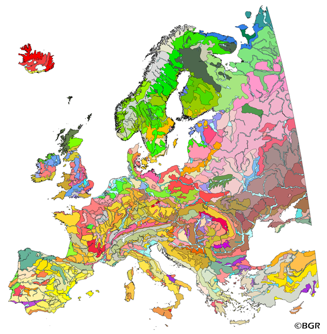
Soil Regions of the European Union and Adjacent Countries 1:5,000,000 (WMS)
The map of the "Soil Regions of the European Union and Adjacent Countries 1:5,000,000 (Version 2.0)" is published by the Federal Institute of Geosciences and Natural Resources (BGR), in partnership with the Joint Research Center (JRC, Ispra). The soil regions map is intended to support the current national mapping activities towards a European 1:250,000 datbase by stratifying similar regional soil associations into a hierarchical concept. Only by stratification, the complexity of soils can be systematically structured so that the complex 1:250,000 legend can be handled in cross-national and contintental-level applications. Soil regions are natural, cross-regional soil geographical units which perform the highest spatial and content-based aggregation of European soils. They represent the frame conditions for soil development at the landscape level. The soil regions are presented at scale 1:5,000,000. Thus, its borders are highly generalized. Because of its low resolution, the map units absorb atypical soils and associations of soils, which are only described in higher resolution soil maps. The delineation of the soil regions is expected to be refined (and probably improved by its content) during the actual 1:250,000 mapping process. Thus, updating can be expected in the future. Currently, the soil regions map is the only graphical soil representation in Europe which has been developed using fully comparable and harmonized basic data at the continental level (climate, hydrography, relief, geology, vegetation): the interpretation of this input data, and the utilization of expert knowledge (including the interpretation of regional soil maps) has been done using one common methodology, developed and applied consistently throughout the whole mapping area by an experienced international soil mapper (Dr. Reinhard Hartwich, former member of BGR, and co-author of the 1998 Manual of Procedures). The methodology is extensively described in the Explanatory Notes (German), and in the revised Manual of Procedures which is expected to be completed soon. It is highly recommended to apply and interpret the map using the map comments and descriptions as provided in the explanatory notes (German: Hartwich et al. 2005; English: revision of the Manual of Procedures, initial version: Finke et al. 2001).
|
|
Citation proposal
. Soil Regions of the European Union and Adjacent Countries 1:5,000,000 (WMS). https://services.mspdata.eu:/geonetwork/srv/api/records/F5624C2A-D5BE-4810-8D66-C0139D471118 |
Simple
Identification info
- Alternate title
- EUSR5000 (WMS)
- Date ( Creation )
- 2010-11-11
- Identifier
- AFC47F2E-43ED-42AA-8EBB-85FCD47FA1D7
- Status
- onGoing On going
Point of contact
Bundesanstalt für Geowissenschaften und Rohstoffe
-
Eberhardt, Einar, Dr.
Stilleweg 2
Hannover
DE-NI
30655
DE
- GEMET - INSPIRE themes, version 1.0 ( Theme )
-
- Boden , Soil
- Keywords ( Theme )
-
- Bodeneigenschaften , Bodenlandschaften , Bodenregionen , Bodenverbreitung , Climate areas , Entstehungsart , infoMapAccessService , landscape stratification , Soil landscapes , Soil parent material associations , soil regions , Soil scapes , EGDI , Europa , Europe
- Keywords ( Place )
-
- Use constraints
- otherRestrictions Other restrictions
- Other constraints
- Die bereitgestellten Informationen sind bei Weiterverwendung wie folgt zu zitieren/The works made available shall be quoted as follows: BGR [Bundesanstalt für Geowissenschaften und Rohstoffe] (2005). Soil Regions Map of the European Union and Adjacent Countries 1:5,000,000 (Version 2.0). Special Publication, Ispra. EU catalogue number S.P.I.05.134.
- Access constraints
- otherRestrictions Other restrictions
- Classification
- Unclassified
- Use limitation
- Die bereitgestellten Informationen sind bei Weiterverwendung wie folgt zu zitieren/The works made available shall be quoted as follows: BGR [Bundesanstalt für Geowissenschaften und Rohstoffe] (2005). Soil Regions Map of the European Union and Adjacent Countries 1:5,000,000 (Version 2.0). Special Publication, Ispra. EU catalogue number S.P.I.05.134.
- Service Type
- view
- Service Version
- OGC:WMS 1.3.0
N
S
E
W
))
Coupled Resource
- Operation Name
- getMap
- Identifier
- 78F40629-3272-40F6-B0AA-C0A353F7A391
- Coupling Type
- Tight
Contains Operations
- Operation Name
- Distributed Computing Platforms
- Web services
- Operates On
- Reference system identifier
- EPSG:3035
- Distribution format
-
- png (n/a )
- jpeg (n/a )
- gif (n/a )
- Hierarchy level
- Service
- Other
- service
Conformance result
- Date ( Publication )
- Explanation
- See the referenced specification
Metadata
- File identifier
- F5624C2A-D5BE-4810-8D66-C0139D471118 XML
- Metadata language
- eng English
- Character set
- utf-8 UTF8
- Hierarchy level
- service Service
- Hierarchy level name
- service
- Date stamp
- 2020-04-22
- Metadata standard name
- ISO 19119/INSPIRE_TG2/CZ4
- Metadata standard version
- 2003/cor.1/2006