Metadata catalogue
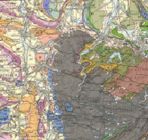
General Geological Map of the Federal Republic of Germany 1:200,000 (GUEK200) (WMS)
The map series General Geological Map of the Federal Republic of Germany 1:200,000 (GÜK200) is the result of cooperation between the State Geological Surveys of the Federal Republic of Germany (SGD), the Geological Surveys of neighbouring countries and the Federal Institute for Geosciences and Natural Resources (BGR). The GÜK200 displays the surface geology of Germany and adjacent areas of neighbouring countries on 55 map sheets. The map sheets show the regional dissemination of more than 3800 geological units. The geological units contain information on stratigraphy (age), genesis and petrography (composition) of the rocks.
|
|
Citation proposal
. General Geological Map of the Federal Republic of Germany 1:200,000 (GUEK200) (WMS). https://services.mspdata.eu:/geonetwork/srv/api/records/C1DE9507-F568-4667-8E2D-F19C4152F64A |
Simple
Identification info
- Alternate title
-
GÜK200 (WMS)
- Date ( Revision )
- 2015-04-15
- Identifier
-
2BC2FF5E-A4E7-4526-964F-2E406AA821EA
- Status
- completed Completed
Point of contact
Stilleweg 2
Hannover
Niedersachsen
30655
DE
- GEMET - INSPIRE themes, version 1.0 ( Theme )
-
-
Geologie
-
- GEMET - Concepts, version 2.4 ( Theme )
-
-
Jura
,Kreide
,Salzstock
,Tektonik
-
- Keywords ( Theme )
-
-
Allgemeine Geologie
,Devon
,Eisrandlagen
,Genese
,Geologische Karte
,infoMapAccessService
,inspireidentifiziert
,Kambrium
,Känozoikum
,Karbon
,Kartenwerk
,Magmatisches Gestein
,Mesozoikum
,Metamorphes Gestein
,Meteoriten
,Ordovizium
,Paläozoikum
,Perm
,Petrographie
,Präkambrium
,Proterozoikum
,Quartär
,Rasterdaten
,Sedimentgestein
,Silur
,Stratigraphie
,Tertiär
,Trias
,Überlagerungen
,Vektordaten
,EGDI
,opendata
-
- Keywords ( Place )
-
-
Bundesrepublik Deutschland
-
- Spatial scope
-
-
National
-
- Classification
- Unclassified
- Use constraints
- otherRestrictions Other restrictions
- Other constraints
-
Nutzungsbedingungen: Allgemeine Geschäftsbedingungen, siehe https://www.bgr.bund.de/AGB - General terms and conditions, see https://www.bgr.bund.de/AGB_en . Die bereitgestellten Informationen sind bei Weiterverwendung wie folgt zu zitieren: Datenquelle: GÜK200, (C) BGR, Hannover, 2015
- Use limitation
-
Nutzungsbedingungen: Allgemeine Geschäftsbedingungen, siehe https://www.bgr.bund.de/AGB - General terms and conditions, see https://www.bgr.bund.de/AGB_en . Die bereitgestellten Informationen sind bei Weiterverwendung wie folgt zu zitieren: Datenquelle: GÜK200, (C) BGR, Hannover, 2015
- Access constraints
- copyright Copyright
- Service Type
- view
- Service Version
-
OGC:WMS 1.3.0
))
Coupled Resource
- Operation Name
-
getMap
- Identifier
-
57208E6C-27D2-41CB-8F7A-8B9091737855
Coupled Resource
- Operation Name
-
getMap
- Identifier
-
85D42300-B573-497A-9114-2CC1AAB9336E
Coupled Resource
- Operation Name
-
getMap
- Identifier
-
73CACED2-1EE1-4BD4-822C-F011D94AC301
Coupled Resource
- Operation Name
-
getMap
- Identifier
-
858BF063-C7DD-4594-A6C3-D4B862B30C07
Coupled Resource
- Operation Name
-
getMap
- Identifier
-
F4849966-3CA3-47F4-9375-4F321C743DE6
Coupled Resource
- Operation Name
-
getMap
- Identifier
-
A10C90F2-EE36-440E-BB8E-BBDE5D48E286
- Coupling Type
- Tight
Contains Operations
- Reference system identifier
-
EPSG:25832
- Distribution format
-
-
png
(n/a
) -
jpeg
(n/a
) -
gif
(n/a
)
-
- OnLine resource
- https://services.bgr.de/wms/geologie/guek200/?REQUEST=GetCapabilities&VERSION=1.3.0&SERVICE=WMS
- OnLine resource
- BGR-Geoviewer
- Hierarchy level
- Service
Conformance result
- Date ( Publication )
- 2009-10-20
- Explanation
-
siehe dazu die angegebene Durchführungsbestimmung
- Statement
-
Erzeugung von wissenschaftl. Manuskripten und Manuskriptkarten bei den Staatl. Geolog. Diensten. Digitalisierung (bei neueren Blättern), Attributierung und Aufbau von Sachdatenbanken, Überlagerung u. Anpassung mit Rastertopographie, Druck u. Publikation -
Metadata
- File identifier
- C1DE9507-F568-4667-8E2D-F19C4152F64A XML
- Metadata language
- ger German
- Character set
- utf-8 UTF8
- Hierarchy level
- service Service
- Hierarchy level name
-
Geologie
- Date stamp
- 2019-11-07
- Metadata standard name
-
INSPIRE Metadata Implementing Rules: Technical Guidelines based on EN ISO 19115 and EN ISO 19119
- Metadata standard version
-
V. 1.2