Metadata catalogue
Search and Rescue Regions
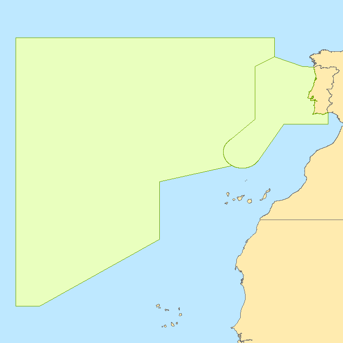
This polygon dataset contains Search and Rescue Regions (SRR) attributed to Portugal (Areas of responsibility of the National System for the Maritime Search and Rescue). These are established marine regions where Portugal is responsible for providing search and rescue of people in danger.
|
|
Citation proposal
. Search and Rescue Regions. https://services.mspdata.eu:/geonetwork/srv/api/records/B8601FA6-0954-4AA8-BC20-57C10DDAFAF8 |
Simple
- Alternate title
- Áreas de Busca e Salvamento Marítimo
- Date ( Creation )
- 2013-10-18
- Identifier
- 59a39aa7-e740-4c8b-a73f-63af5793673a
- Purpose
- Estes dados são apenas para efeitos de visualização.
- Status
- Concluído Completed
Point of contact
- Website
- http://www.hidrografico.pt
- Maintenance and update frequency
- Não Planeada Not planned
- GEMET - INSPIRE themes, version 1.0 ( Theme )
-
- Zonas de gestão/restrição/regulamentação e unidades de referência
- Keywords
-
- IH
- Thesaurus SNIMar v.0.x ( parameter )
-
- Regiões de Busca e Salvamento
- Thesaurus SNIMar v.0.x ( Discipline )
-
- Limites Estabelecidos por Lei ou Convenção
- Use limitation
- Estes dados não substituem as cartas náuticas; não podem ser utilizados para navegação. Para navegação, os navegadores deverão utilizar as Cartas Náuticas publicadas pelo IH.
- Access constraints
- Outras Restrições Other restrictions
- Use constraints
- Direitos de Autor Copyright
- Other constraints
- Descarregamento gratuito. Apenas dados de referência, não oficiais. Não podem ser utilizados para fins comerciais, mas apenas para fins de utilização pessoal e/ou para fins de investigação e deve ser sempre feita referência à sua origem, no caso de serem utilizados na produção de publicações científicas.
- Spatial representation type
- Vectorial Vector
- Denominator
- -1
- Metadata language
- Português Portuguese
- Character set
- utf8 UTF8
- Topic category
-
- Oceans
- Economy
- Transportation
N
S
E
W
))
- Reference system identifier
- EPSG / http://www.opengis.net/def/crs/EPSG/0/4326
- Distribution format
-
- Zipped shapefile (N/A )
- Transfer size
- 4.04
- Hierarchy level
- Conjunto de Dados Geográficos Dataset
Conformance result
- Date ( Publication )
- 2010-12-08
- Explanation
- Ver a especificação citada.
- Pass
- false
- Statement
- The areas of responsibility of the National System for the Maritime Search and Rescue (SAR) are defined by the following search and rescue regions, which comprise: a) The search and rescue region of Lisbon (SRR Lisbon); b) The search and rescue region of Santa Maria (SRR Santa Maria). A search and rescue region is an area of defined dimensions within which search and rescue services are provided. This dataset comes from the nautical charts produced by the Hydrographic Institute. The dataset was created by the Hydrography Division according to the document SAR.8/Circ.3 "AVAILABILITY OF SEARCH AND RESCUE (SAR) SERVICES" - 17 June 2011. The legal document that defines the SRR is Decree-Law No. 15/94 of January 22, establishing the National System for the Maritime Search and Rescue. The data available for free download are only reference data, not official.
- Description
- Cartas náuticas
Metadata
- File identifier
- B8601FA6-0954-4AA8-BC20-57C10DDAFAF8 XML
- Metadata language
- Português Portuguese
- Character set
- utf8 UTF8
- Hierarchy level
- Conjunto de Dados Geográficos Dataset
- Date stamp
- 2015-12-23
- Metadata standard name
- Perfil SNIMar
- Metadata standard version
- v.0.9.3
Point of contact
- Website
- http://www.hidrografico.pt