Metadata catalogue
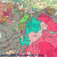
General Geological Map of the Federal Republic of Germany 1:200,000
The map series General Geological Map of the Federal Republic of Germany 1:200,000 (GÜK200) is the result of cooperation between the State Geological Surveys of the Federal Republic of Germany (SGD), the Geological Surveys of neighbouring countries and the Federal Institute for Geosciences and Natural Resources (BGR). The GÜK200 displays the surface geology of Germany and adjacent areas of neighbouring countries on 55 map sheets. The map sheets show the regional dissemination of more than 3800 geological units. The geological units contain information on stratigraphy (age), genesis and petrography (composition) of the rocks.
Each printed/scanned map sheet contains one or several geological cross-sections which give an insight into the subsurface.
The digital data of the map series are stored separately for each map sheet. According to this geological units/polygons, their boundaries, tectonic linear elements and, if present, ice sheet boundaries are saved as a discrete layer in a shapefile for the single map sheets. The attributes of the geological units contain information – like in the printed map sheets – on stratigraphy, genesis and petrography of the rocks.
|
|
Citation proposal
(2007) . General Geological Map of the Federal Republic of Germany 1:200,000. https://services.mspdata.eu:/geonetwork/srv/api/records/ABA9633F-E0BA-438D-918C-6B3BEB4D641C |
Simple
- Alternate title
- GÜK200 (Serie)
- Date ( Publication )
- 2007-03-09
- Identifier
- 57208E6C-27D2-41CB-8F7A-8B9091737855
- Other citation details
- Hinweis: PDF, JPG, TIFF sind gescannte Druckausgaben! - Note: PDF, JPG, TIFF are based on scanned printed edition!
- Status
- completed Completed
Point of contact
- GEMET - INSPIRE themes, version 1.0 ( Theme )
-
- Geologie
- Keywords ( Theme )
-
- Allgemeine Geologie , inspireidentifiziert , EGDI , opendata
- Keywords ( Place )
-
- Deutschland
- Spatial scope
-
- National
- Classification
- Unclassified
- Use limitation
- Allgemeine Geschäftsbedingungen, s. https://www.bgr.bund.de/agb - General Terms and Conditions, s. https://www.bgr.bund.de/agb_en
- Use limitation
- Nutzungsbedingungen: Dieser Datensatz kann gemäß der "Nutzungsbestimmungen für die Bereitstellung von Geodaten des Bundes" (https://sg.geodatenzentrum.de/web_public/gdz/lizenz/geonutzv.pdf) genutzt werden.
- Access constraints
- copyright Copyright
- Use constraints
- license License
- Use constraints
- otherRestrictions Other restrictions
- Other constraints
- Nutzungsbedingungen: Dieser Datensatz kann gemäß der "Nutzungsbestimmungen für die Bereitstellung von Geodaten des Bundes" (https://sg.geodatenzentrum.de/web_public/gdz/lizenz/geonutzv.pdf) genutzt werden.
- Other constraints
- {"id": "geoNutz/20130319", "name": "Nutzungsbestimmungen für die Bereitstellung von Geodaten des Bundes", "url": "https://sg.geodatenzentrum.de/web_public/gdz/lizenz/geonutzv.pdf", "quelle": "Bundesanstalt für Geowissenschaften und Rohstoffe (BGR)"}
- Spatial representation type
- grid Grid
- Spatial representation type
- vector Vector
- Denominator
- 200000
- Metadata language
- ger German
- Character set
- utf8 UTF8
- Topic category
-
- Geoscientific information
))
- Reference system identifier
- EPSG:31467 - Datum DHDN, Gauß-Krüger-Abbildung, 3 Grad Streifenbreite, 3. Meridianstreifen
- Distribution format
-
- PDF (n/a )
- Shapefile (n/a )
- JPEG (n/a )
- TIFF (n/a )
- GEOTIFF (n/a )
- OnLine resource
- https://produktcenter.bgr.de/terraCatalog/DetailResult.do?fileIdentifier=ABA9633F-E0BA-438D-918C-6B3BEB4D641C
- OnLine resource
-
Testdaten - testdata
Testdaten - testdata
- OnLine resource
-
Indexkarte
Indexkarte
- OnLine resource
-
Karte im BGR-Geoviewer
Karte im BGR-Geoviewer
- Hierarchy level
- Series
Conformance result
- Date ( Publication )
- 2010-12-08
- Explanation
- siehe dazu die angegebene Durchführungsbestimmung
- Statement
- -
Metadata
- File identifier
- ABA9633F-E0BA-438D-918C-6B3BEB4D641C XML
- Metadata language
- ger German
- Character set
- utf-8 UTF8
- Hierarchy level
- series Series
- Hierarchy level name
- Geologie
- Date stamp
- 2021-04-22
- Metadata standard name
- INSPIRE Metadata Implementing Rules: Technical Guidelines based on EN ISO 19115 and EN ISO 19119
- Metadata standard version
- V. 1.2