Metadata catalogue
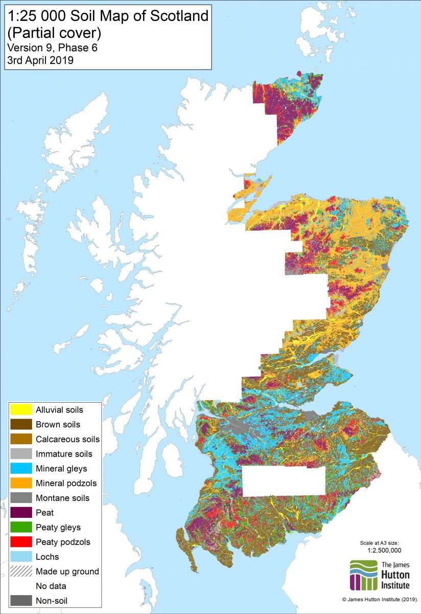
1:25 000 Soil Map of Scotland (Partial cover)
|
|
Citation proposal
Colin Campbell (The James Hutton Institute). 1:25 000 Soil Map of Scotland (Partial cover). https://services.mspdata.eu:/geonetwork/srv/api/records/9b16b1cb-ed65-4864-a360-43fa7f038500 |
Simple
- Alternate title
- Soils of Scotland 1:25,000 Soils vector
- Date ( Creation )
- 1981-01-01
- Identifier
- soils25k_v9d
- Presentation form
- mapDigital Digital map
Custodian
Processor
- Maintenance and update frequency
- irregular Irregular
- Name
- ESRI Shapefile
- Version
- 1.0
- Keywords
-
- soil , land form , base material
- GEMET - INSPIRE themes, version 1.0 ( Theme )
-
- Soil
- Access constraints
- otherRestrictions Other restrictions
- Other constraints
- no limitations on public access
- Use limitation
- This data was produced at a scale of 1:25,000. Smaller scale data is available for the whole of Scotland. Use is permitted under the terms of the Open Data licence included in the download.
- Spatial representation type
- vector Vector
- Denominator
- 25000
- Metadata language
- eng English
- Topic category
-
- Farming
- Geoscientific information
- Geographic identifier
- GB-SCT
))
- Reference system identifier
- EPSG / OSGB 1936 / British National Grid (EPSG:27700) / 7.9
- Distribution format
-
- ESRI Shapefile (1.0 )
Distributor
Distributor
- Fees
- None
- Ordering instructions
- Download from http://www.hutton.ac.uk/sites/default/files/files/soils/downloads/Hutton_Soils25K_OpenData_v9_Phase5.zip
- Turnaround
- None
- Name
- ESRI Shapefile
- Version
- 1.0
- OnLine resource
-
ESRI Shapefile Download
ESRI Shapefile Download
- OnLine resource
-
0
1:25 000 Soil Map of Scotland (Partial cover)
- Hierarchy level
- dataset Dataset
- Statement
-
Data gathering: Start: 1947, End: 1987
Collection methods: A source document was chosen. The order of preference was dyeline master, clean copy, compilation then working draft. The document was overlayed with a piece of matte plastic on which the details of the source were recorded, registration marks were drawn and three tablet reference points were indicated. An overlap on 1-2mm was drawn if there was no suitable line on the base map. The map was then compared with its neighbours and the detail drawn into the overlap area which avoided underlap problems later. A check was made of the coding across sheets. Problems with line placement or coding were noted on a query sheet. The soil lines were digitised following the centre of the line and continuing into the overlap area. Stream digitising was not used. Nodes were snapped where two or more lines met at a point. The line file was cloned to make the point file, to ensure that the geo-referencing was the same in both files and the lines were then deleted from the point file. Rubbersheeting points were digitised at every grid intersection on the base map, ie every 1km intersection. Rubbersheeting points were given the code of 1. Soil codes are shown on the 1:63,360 map as letters indicating soil association and soil series. These letter codes were translated back to the five digit numbers used in the Oracle table Soils of Scotland Soil Series Codes (4100001001). A single point was digitised within each polygon and the appropriate five digit code assigned to it. A plot was made, checked against the original and any discrepancies noted. Queries were noted on the query sheet and passed with the map to a soil surveyor to be resolved. Once all the edits had been completed a final plot was made and passed to another member of the digitising team, for a final check. Files were made which would be acceptable to ARC/Info. Coverages were generated, rubbersheeted, and the rubbersheeting points removed. Clipped with LCS88 coastline and lochs and finally edgematched to its neighbours.
Originator: Formerly DAFS (Department of Agriculture and Fisheries for Scotland), then SOAEFD (Scottish Office Agriculture, Environment and Fisheries Department), now SERAD (Scottish Executive Rural Affairs Department)
Data collectors: SURVEYING: John S Bell, John S Bibby, Eric L Birse, Cyril J Bown, Colin GB Campbell, J Cruickshank, DT Davies, HG Dion, Frank T Dry, NA Duncan, Donald W Futty, James H Gauld, Robert Glentworth, CJ Grant, Robert Grant, PC Harper, R Hart, David J Henderson, Rodney EF Heslop, J Andrew Hipkin, Gordon Hudson, JI Jack, WD Jardine, RA Jarvis, Donald Laing, DM Lang, RD Law, E Lawrence, Allan Lilly, JM Mackay, RC Mackenzie, J Menzies, DW Merrilees, BD Mitchell, RJF Morris, John W Muir, MJ Mulcahy, Andrew J Nolan, GE Orbell, JM Ragg, James S Robertson, J Charles C Romans, Brian M Shipley, J Smith, JH Stevens, WR Strachan, William Towers, Alexander D Walker, Gary G Wright. DIGITISING: Jaik Campbell, Susan MacLeay, Sandy Moir, Ruth A Morrison, David Tulett, David Donnelly, Grant Campbell, Keith Marshall, Hans Hengelaar. QUERY CHECKING: John S Bell, Andrew J Nolan.
This data set has received a phased revision.
This version of the data is Phase Six and it supersedes previous phases, it is being released on 2nd April 2019. This includes all the data previously issued. This release continues within Version 9 but adopts the suffix Phase 6 to show continuity with previous phases. Phase 6 includes an additional 1,637 km2 in the north and 1,682 km2 in the south. Additional areas will be digitised between 2019 and 2021 and made available. In the southern area (corresponding to sheets NY48/49/58/59) as no large scale published soils maps have been created, the soils data relating to these maps was collected largely at a reconnaissance level for the 1:250,000 scale soil survey and was enhanced by interpretation of aerial photograph imagery.
The previous version of the data was Phase Five, the first revision in the Version 9 of the data (first released in 2018), and it superseded Phases One, Two, Three & Four of Version 8 of the data. It was released on 9th March 2018. This includes all the data previously issued. That version did not include the information on which parts of the data were edited under each phase as it was intended to represent a stable version of the data, the detailed information on each phase is available on request. Additional areas will be digitised between 2018 and 2021 and made available. This release (Phase 5) included a substantial additional area of data (3,374 km2) in the south-west of Scotland. This has been digitised from unpublished draft maps and manuscripts kept in the Hutton map archive.
The attribute table for Phase 3 revision incorporated new column names compared to previous releases of this data which fit within the naming protocol for soil attributes within Scotland’s National Soils Database and made significant progress towards a seamless integration of datasets.
Phase 4 release included previously unreleased data in Angus and the south-west of Scotland to ensure that the NVZ area updated in 2015/16 was covered by soils data at this scale. A section of the data north of Nithsdale being at smaller scale (less detailed) than the dataset as a whole, has been removed.
In Phase 4 release there was some minor reclassifications of soil series for some of the map units including map units with moundy topography and peat in the intervening hollows, particularly classifying the peat as either confined or semi-confined. Additional information on the constituent soils of some soil complexes has been added. Major soil subgroup code on ‘0.0.0’ has been added where there is no information available to classify the soils. This mainly affects a few small soil complexes.
Phase 3 release included modifications to Strichen and Arkaig Associations as described below:
Strichen and Arkaig Associations
Prior to the completion of the 1:250 000 scale national soil map, soils developed from schists were allocated to the Strichen Association, however, during the national scale mapping, this Association was divided into two based on the stratigraphic age of the Schist (Moine or Dalradian) giving rise to the Arkaig Association (Moine Schists). The extent of these two Associations followed the geological mapping and some soils previously allocated to the Strichen Association were reclassified as belonging to the Arkaig Association. Subsequent revisions of the geological map have relocated the boundary between the Moine and Dalradian Schist such that the soils reallocated to the Arkaig Association are in areas now mapped as Dalradian Schists by geologists. During the revisions of the 1:25 000 and 1:63 360 scale soil maps, it was decided to revert to the soil Association to which the soils in this area were allocated originally, thus the areas allocated to either the Strichen or Arkaig associations on the more detailed maps will differ from the national scale map.
Ownership of this data set was passed to the James Hutton Institute on 1st April 2011.
Metadata
- File identifier
- 9b16b1cb-ed65-4864-a360-43fa7f038500 XML
- Metadata language
- eng English
- Hierarchy level
- dataset Dataset
- Date stamp
- 2019-04-03
- Metadata standard name
- ISO 19115:2003/19139
- Metadata standard version
- 1.0