Metadata catalogue
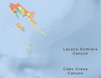
Bathymétrie - golfe du Lion, canyon Lacaze-Duthiers, résolution 2 m (campagne CALADU_2021, 2021)
Bathymétrie du canyon Lacaze-Duthiers (campagne CALADU_2021, 2021), au pas de 2 mètres. Ce jeu de données est un Modèle Numérique de Terrain bathymétrique, issu de l'acquisition acoustique du sondeur multifaisceau EM2040 du N/O Thalassa.
Référence verticale : niveau de la mer observé (pas de correction de marée)
Rapport de traitement : Gaillot Arnaud (2024). CALADU_2021. Traitement des données SMF coque et engin. Ref. ASTI-2024-331. Ifremer.
Description de la campagne : FABRI Marie-Claire (2021) CALADU_2021 cruise, RV Thalassa, https://doi.org/10.17600/18001575
|
|
Citation proposal
Ifremer Geo-Ocean (Ifremer) (2024) . Bathymétrie - golfe du Lion, canyon Lacaze-Duthiers, résolution 2 m (campagne CALADU_2021, 2021). Ifremer https://services.mspdata.eu:/geonetwork/srv/api/records/9936ab76-b054-43de-8688-8450e1ae7493 |
Simple
- Date ( Publication )
- 2024-10-24
- Date ( Creation )
- 2023-09-15
- Identifier
- FR-330715-368-00032-Caladu21_LacazeDuthiers_2m_BATHY
- Credit
- Ifremer
Author
Publisher
Point of contact
- Thèmes Sextant Thèmes Sextant ( Theme )
-
- /Milieu physique/Bathymétrie /Milieu physique/Bathymétrie /Physical Environment/Bathymetry
- GEMET - INSPIRE themes, version 1.0 GEMET - INSPIRE themes, version 1.0 ( Theme )
-
- Altitude Altitude Elevation
- GEMET - Concepts, version 2.4 GEMET - Concepts, version 2.4 ( Theme )
-
- géomorphologie géomorphologie geomorphology , fond marin fond marin sea bed
- Keywords ( Discipline )
-
- Bathymétrie
- Use limitation
- CC-BY (Creative Commons - Attribution) CC-BY (Creative Commons - Attribution) CC-BY (Creative Commons - Attribution)
- Access constraints
- Other restrictions
- Use constraints
- License
- Other constraints
- Pas de restriction d'accès public
- Other constraints
- Use limitation
- Ne pas utiliser pour la navigation
- Aggregate Datasetindentifier
- 091ccc99-843d-49bf-a0b8-db543f704d1f
- Association Type
- Cross reference
- Aggregate Datasetindentifier
- 74492729-a034-42ee-a517-7037cda010b4
- Association Type
- Cross reference
- Aggregate Datasetindentifier
- aa4b9569-33d6-476c-bdb8-5e0ac114854d
- Association Type
- Cross reference
- Spatial representation type
- grid Grid
- Denominator
- 4000
- Distance
- 2 meter
- Metadata language
- French
- Character set
- utf8 UTF8
- Topic category
-
- Oceans
))
- Codespace
- EPSG
- Version
- 7.4
Spatial representation info
- Number of dimensions
- 0
- Cell geometry
- Area
- Distribution format
-
- GeoTIFF (1.0 )
- OnLine resource
-
Caladu2021_LacazeDuthiers_2m_BATHY
Caladu2021_LacazeDuthiers_2m_BATHY
- OnLine resource
-
Caladu2021_LacazeDuthiers_2m_BATHY
Caladu_2021 : bathymétrie du canyon Lacaze-Duthiers, résolution 2 m
- Protocol
- COPYFILE
- Name
- Caladu2021_LacazeDuthiers_2m_BATHY
- Description
- Caladu2021_LacazeDuthiers_2m_BATHY
- Hierarchy level
- Dataset
Domain consistency
Conformance result
- Date ( Publication )
- 2010-12-08
- Explanation
- See the referenced specification
- Statement
- Consulter le rapport de traitement.
Metadata
- File identifier
- 9936ab76-b054-43de-8688-8450e1ae7493 XML
- Metadata language
- French
- Character set
- UTF8
- Hierarchy level
- Dataset
- Date stamp
- 2025-05-15T23:26:22.255311Z
- Metadata standard name
- ISO 19115-3 - SEXTANT ISO 19115-3 - SEXTANT
- Metadata standard version
- 1.0