Metadata catalogue
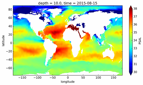
ISAS-SSS - In situ Sea Surface Salinity gridded fields
The In Situ Analysis System (ISAS) was developed to produce gridded fields of temperature and salinity that preserve as much as possible the time and space sampling capabilities of the Argo network of profiling floats. The ISAS-SSS configuration provide Sea Surface Salinity gridded fields from in-situ measurements including Argo, Moorings, Marine Mammals, GOSUD Thermosalinometer SSS measurements from delayed mode SNO-SSS merchant ships ( http://www.legos.obs-mip.fr/observations/sss ), French research vessels ( http://doi.org/10.17882/3947 5) and sails ( http://doi.org/10.17882/39476 ). A careful delayed mode processing of the 2002-2015 dataset has been carried out using version 7 of ISAS and updating the statistics to produce the ISAS-15 analysis. The ISAS-SSS fields appears as highly valuable for the "calibration and validation" of the new satellite observations delivered by SMOS, Aquarius and SMAP.
|
|
Citation proposal
Nicolas Kolodziejczyk (LOPS – UMR 6523 CNRS) - Prigent-Mazella Annaig (IFREMER) - Fabienne Gaillard (Ifremer, LPO – UMR 6523 CNRS, Ifremer, IRD, UBO) (2018) . ISAS-SSS - In situ Sea Surface Salinity gridded fields. IFREMER / IDM/SISMER https://services.mspdata.eu:/geonetwork/srv/api/records/97b4842b-94b3-4205-8781-476813d8177b |
Simple
- Date ( Publication )
- 2018-06-01T00:00:00
- Identifier
-
14b77ddf-73cd-4084-b4e9-311654209a10
- Identifier
-
DOI:10.17882/55600
- Purpose
- Credit
-
LOPS, CNRS/UBO/Ifremer/IRD, France
- Status
- On going
Author
Centre Bretagne - ZI de la Pointe du Diable - CS 10070 - 29280 Plouzané
Brest
France
Publisher
- Maintenance and update frequency
- As needed
- Keywords ( Theme )
-
-
climate variability
,ocean heat content
,fresh water cycle
,Thématique SST Satellite
-
- GEMET - INSPIRE themes, version 1.0 ( Theme )
-
-
Oceanographic geographical features
-
- Variables Odatis ( Theme )
-
-
/Physical Oceanography/Salinity
,/Physical Oceanography/Temperature
-
- Centre de données - ODATIS ( Theme )
-
-
CDS-IS-SISMER
-
- Type de jeux de donnée - ODATIS ( Theme )
-
- Thèmatiques - ODATIS ( Theme )
-
-
Added-value products
-
- Use limitation
-
CC-BY
- Access constraints
- Other restrictions
- Other constraints
-
A user should acknowledge use of data in all publications and products where such data are used.
- Spatial representation type
- Grid
- Denominator
- 1000000
- Metadata language
- English
- Character set
- UTF8
- Topic category
-
- Oceans
))
Vertical extent
- Supplemental Information
- Reference system identifier
-
EPSG
/WGS 84 (EPSG:4326)
/7.9
- Number of dimensions
- 0
- Distribution format
-
- ()
- OnLine resource
- DOI of the dataset
- Hierarchy level
- Dataset
Conformance result
- Date ( Creation )
- 2012-01-16
- Explanation
-
Non évalué
- Pass
- false
- Statement
Metadata
- File identifier
- 97b4842b-94b3-4205-8781-476813d8177b XML
- Metadata language
- English
- Character set
- UTF8
- Hierarchy level
- Dataset
- Date stamp
- 2019-04-23T14:52:55
- Metadata standard name
-
ISO 19115:2003/19139 - SEXTANT
- Metadata standard version
-
1.0