Metadata catalogue
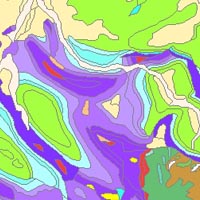
Geological Map of Germany 1:1,000,000 OneGeology-Europe (GK1000-1GE) (WMS)
The “Geological Map of Germany 1:1,000,000 OneGeology-Europe (GK1000-1GE)” shows Germany’s surface geology: All geological units are described by their age (stratigraphy) and composition (lithology). The geological units and terms used in this map were semantically harmonized within the OneGeology-Europe project and have been - in a number of regions - geometrically and semantically made consistent with the neighbouring OneGeology-Europe participants.
|
|
Citation proposal
. Geological Map of Germany 1:1,000,000 OneGeology-Europe (GK1000-1GE) (WMS). https://services.mspdata.eu:/geonetwork/srv/api/records/908b2f4f-5b3a-47cb-9b40-6f76c9db5389 |
Simple
Identification info
- Alternate title
- GK1000-1GE (WMS)
- Date ( Creation )
- 2018-06-07
- Identifier
- 92af2cb5-48c6-43a7-b49e-2956b017ee0c
- Status
- completed Completed
Point of contact
Bundesanstalt für Geowissenschaften und Rohstoffe (BGR)
-
Vinnemann, Christa
Stilleweg 2
Hanover/Hannover
30655
DE
- GEMET - INSPIRE themes, version 1.0
-
- Geology , Geologie
- GEMET - Concepts, version 2.4 ( Theme )
-
- Earth science , Geowissenschaften
- Keywords ( Theme )
-
- OneGeology , OneGeology-Europe , Oberflächengeologie , Petrology , Petrologie , Lithology , Lithologie , Stratigraphy , Stratigraphie , Harmonized geology , Harmonisierte Geologie , Harmonized age , EGDI , Harmonisiertes Alter , Harmonized data , Harmonisierte Daten , infoMapAccessService , Germany , Deutschland , Bedrock , Anstehendes Gestein , Superficial deposits , Oberflächenablagerung , Surface geology
- Keywords ( Place )
-
- Germany , Deutschland
- Classification
- Unclassified
- Use constraints
- otherRestrictions Other restrictions
- Other constraints
- General terms and conditions, see https://www.bgr.bund.de/AGB_en - Allgemeine Geschäftsbedingungen, s. https://www.bgr.bund.de/agb. In case of reuse the information provided should be cited as follows: "Data Source: OneGeology-Europe harmonized geology, (c) BGR Hanover, 2018"
- Service Type
- view
- Service Version
- OGC:WMS 1.3.0
N
S
E
W
))
Coupled Resource
- Operation Name
- GetMap
- Identifier
- 736254e8-2a7e-49bc-bdee-4d8158a444cb
- Coupling Type
- Tight
Contains Operations
- Operation Name
- GetCapabilities
- Distributed Computing Platforms
- WebService
Contains Operations
- Operation Name
- GetMap
- Distributed Computing Platforms
- WebService
- Operates On
- Distribution format
-
- png (n/a )
- jpeg (n/a )
- gif (n/a )
- Hierarchy level
- Service
Conformance result
- Date ( Publication )
- 2010-12-08
- Explanation
- See the referenced specification
- Statement
- This dataset is based on the Geological Map of Germany 1:1,000,000 (GK1000).
Metadata
- File identifier
- 908b2f4f-5b3a-47cb-9b40-6f76c9db5389 XML
- Metadata language
- eng English
- Character set
- utf-8 UTF8
- Hierarchy level
- service Service
- Hierarchy level name
- Geologie
- Date stamp
- 2018-06-08
- Metadata standard name
- ISO 19115/INSPIRE_TG2/CZ4
- Metadata standard version
- V. 1.2