Metadata catalogue
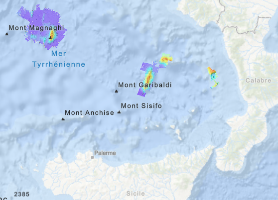
Bathymétrie - mer Tyrrhénienne (campagne ULYXDEMO 2024), résolution 30 m
Bathymétrie de la mer Tyrrhénienne en Méditerranée, au pas de 30 mètres. Ces jeux de données sont des Modèles Numériques de Terrain bathymétriques, issus de l'acquisition acoustique du sondeur multifaisceau EM122 de l'Atalante. Quatre MNT sont disponibles :
- mont sous-marin Sergey Vasilov
- bassin Propeller (bassin Paola)
- mont sous-marin Palinuro
- mont sous-marin Marsili
Référence verticale : Niveau observé des mers
Rapport de traitement : Guerin Charline (2025). ULYXDEMO24 Leg2 - Traitement des données SMF coque et Ulyx. REM/GEOOCEAN/ANTIPOD/25-01
Description de la campagne : RAUGEL Ewen, ESCARTIN Javier (2024) ULYXDEMO 2024 cruise, RV L'Atalante, https://doi.org/10.17600/18003780
|
|
Citation proposal
Geo-Ocean (UMR 6835) (Ifremer) (2024) . Bathymétrie - mer Tyrrhénienne (campagne ULYXDEMO 2024), résolution 30 m. Ifremer https://services.mspdata.eu:/geonetwork/srv/api/records/906978a3-63b0-484f-b0ca-7da573761db1 |
Simple
- Date ( Creation )
- 2024-10-23
- Date ( Publication )
- 2024-11-15
- Identifier
- FR-330715-368-00032-ULYXDEMO2024_Marsili_30m_BATHY.tif
- Credit
- Ifremer
Publisher
- Thèmes Sextant Thèmes Sextant ( Theme )
-
- /Milieu physique/Bathymétrie /Milieu physique/Bathymétrie /Physical Environment/Bathymetry
- GEMET - INSPIRE themes, version 1.0 GEMET - INSPIRE themes, version 1.0 ( Theme )
-
- Altitude Altitude Elevation
- GEMET - Concepts, version 2.4 GEMET - Concepts, version 2.4 ( Theme )
-
- géomorphologie géomorphologie geomorphology , fond marin fond marin sea bed
- Keywords ( Discipline )
-
- Bathymétrie , Méditerranée
- Use limitation
- Les données en eaux étrangères sont diffusables uniquement sous réserve d'otenir l'autorisation du pays concerné. utilisation réservée à l'Ifremer pour un usage interne.
- Access constraints
- Restricted
- Use constraints
- Restricted
- Other constraints
- Use limitation
- Ne pas utiliser pour la navigation
- Aggregate Datasetindentifier
- 0220ccb5-4218-4bfc-9f31-35945cd5eab5
- Association Type
- Cross reference
- Aggregate Datasetindentifier
- 95c48970-abed-4c9f-a3a2-aa2612ee8517
- Association Type
- Cross reference
- Aggregate Datasetindentifier
- ed228877-adf8-4026-b945-83a65566bada
- Association Type
- Cross reference
- Aggregate Datasetindentifier
- e9e5b746-ebc0-4c3a-a302-a61091bc5a57
- Association Type
- Cross reference
- Aggregate Datasetindentifier
- 35e992ed-29f9-4215-900d-4a248ea8f1b7
- Association Type
- Cross reference
- Aggregate Datasetindentifier
- 56a6680d-30fd-42d2-883b-f4164ecfa536
- Association Type
- Cross reference
- Aggregate Datasetindentifier
- f3174ade-e590-4687-a144-47d8a12c67d7
- Association Type
- Cross reference
- Aggregate Datasetindentifier
- 5498fe09-1d5c-417b-a692-756913bf113c
- Association Type
- Cross reference
- Association Type
- Cross reference
- Initiative Type
- Platform
- Spatial representation type
- grid Grid
- Denominator
- 60000
- Distance
- 30 meter
- Metadata language
- French
- Character set
- utf8 UTF8
- Topic category
-
- Oceans
))
))
))
))
- Codespace
- EPSG
- Version
- 7.4
Spatial representation info
- Number of dimensions
- 0
- Cell geometry
- Area
- Distribution format
-
- GeoTIFF (1.0 )
- OnLine resource
-
ULYXDEMO2024_Marsili_30m_BATHY
ULYXDEMO2024 : bathymétrie - mont sous-marin Marsili
- OnLine resource
-
ULYXDEMO2024_Palinuro_30m_BATHY
ULYXDEMO2024 : bathymétrie - mont sous-marin Palinuro
- OnLine resource
-
ULYXDEMO2024_Propeller_30m_BATHY
ULYXDEMO2024 : bathymétrie - bassin Propeller
- OnLine resource
-
ULYXDEMO2024_Vavilov_30m_BATHY
ULYXDEMO2024 : bathymétrie - mont sous-marin Vavilov
- Hierarchy level
- Dataset
Domain consistency
Conformance result
- Date ( Publication )
- 2010-12-08
- Explanation
- See the referenced specification
- Statement
-
Traitements des données acoustiques a été réalisé avec le logiciel GLOBE V2.5.8
- Filtrage automatique des sondes
- Contrôle qualité manuel
Metadata
- File identifier
- 906978a3-63b0-484f-b0ca-7da573761db1 XML
- Metadata language
- French
- Character set
- UTF8
- Hierarchy level
- Dataset
- Date stamp
- 2025-09-22T07:35:07.458224Z
- Metadata standard name
- ISO 19115-3 - SEXTANT ISO 19115-3 - SEXTANT
- Metadata standard version
- 1.0