Metadata catalogue
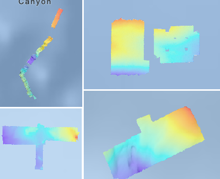
Bathymétrie - Méditerranée, plongées d'essais Ulyx (campagne ESSULYX-2022-1, 2022)
Bathymétrie au large des côtes de Provence-Alpes-Côte d'Azur, en mer Méditerranée, au pas de 1 mètre. Ces jeux de données sont des Modèles Numériques de Terrain bathymétriques, issus de l'acquisition acoustique du sondeur multifaisceaux du robot autonome sous-marin ULYX, lors de ses plongées d'essai (campagne ESSULYX-2022-1, 2022).
Quatre rasters sont disponibles :
- plongée 03, projection de Mercator modifiée (43.1°N, 5.7°E)
- plongée 05, projection de Mercator modifiée (43°N, 0°E)
- plongée 07, projection de Mercator modifiée (42.8°N, 6.9°E)
- plongée 08, projection de Mercator modifiée (43.3°N, 7°E)
Référence verticale : inconnue
Description de la campagne : BRIGNONE Lorenzo (2022) ESSULYX-2022-1 cruise, RV Pourquoi pas ?, https://doi.org/10.17600/18002760
|
|
Citation proposal
Ifremer Geo-Ocean (Ifremer) (2024) . Bathymétrie - Méditerranée, plongées d'essais Ulyx (campagne ESSULYX-2022-1, 2022). Ifremer https://services.mspdata.eu:/geonetwork/srv/api/records/88bf8468-be8d-4bee-9686-ce67c16680df |
Simple
- Date ( Publication )
- 2024-10-18
- Date ( Creation )
- 2023-09-19
- Identifier
- FR-330715-368-00032-Essulyx2022_1_AUV03_1m_BATHY
- Credit
- Ifremer
Author
Publisher
- Thèmes Sextant Thèmes Sextant ( Theme )
-
- /Milieu physique/Bathymétrie /Milieu physique/Bathymétrie /Physical Environment/Bathymetry
- GEMET - INSPIRE themes, version 1.0 GEMET - INSPIRE themes, version 1.0 ( Theme )
-
- Altitude Altitude Elevation
- GEMET - Concepts, version 2.4 GEMET - Concepts, version 2.4 ( Theme )
-
- fond marin fond marin sea bed , géomorphologie géomorphologie geomorphology
- Keywords ( Discipline )
-
- Bathymétrie
- Use limitation
- CC-BY (Creative Commons - Attribution) CC-BY (Creative Commons - Attribution) CC-BY (Creative Commons - Attribution)
- Access constraints
- Other restrictions
- Use constraints
- License
- Other constraints
- Pas de restriction d'accès public
- Use limitation
- Ne pas utiliser pour la navigation
- Spatial representation type
- grid Grid
- Distance
- 1 meter
- Metadata language
- French
- Character set
- utf8 UTF8
- Topic category
-
- Oceans
))
))
))
))
- Codespace
- EPSG
- Version
- 7.4
Spatial representation info
- Number of dimensions
- 0
- Cell geometry
- Area
- Number of dimensions
- 0
- Cell geometry
- Area
- Distribution format
-
- GeoTIFF (1.0 )
- OnLine resource
-
Essulyx2022_1_AUV03_1m_BATHY
Essulyx2022_1_AUV03_1m_BATHY
- OnLine resource
-
Essulyx2022_1_AUV05_1m_BATHY
Essulyx2022_1_AUV05_1m_BATHY
- OnLine resource
-
Essulyx2022_1_AUV07_1m_BATHY
Essulyx2022_1_AUV07_1m_BATHY
- OnLine resource
-
Essulyx2022_1_AUV08_1m_BATHY
Essulyx2022_1_AUV08_1m_BATHY
- Protocol
- COPYFILE
- Name
- Essulyx2022_1_AUV
- Description
- Essulyx2022_1_AUV
- Hierarchy level
- Dataset
Domain consistency
Conformance result
- Date ( Publication )
- 2010-12-08
- Explanation
- See the referenced specification
- Statement
- Pas d'information sur le traitement de données.
Metadata
- File identifier
- 88bf8468-be8d-4bee-9686-ce67c16680df XML
- Metadata language
- French
- Character set
- UTF8
- Hierarchy level
- Dataset
- Date stamp
- 2025-05-15T23:12:22.779591Z
- Metadata standard name
- ISO 19115-3 - SEXTANT ISO 19115-3 - SEXTANT
- Metadata standard version
- 1.0