Metadata catalogue
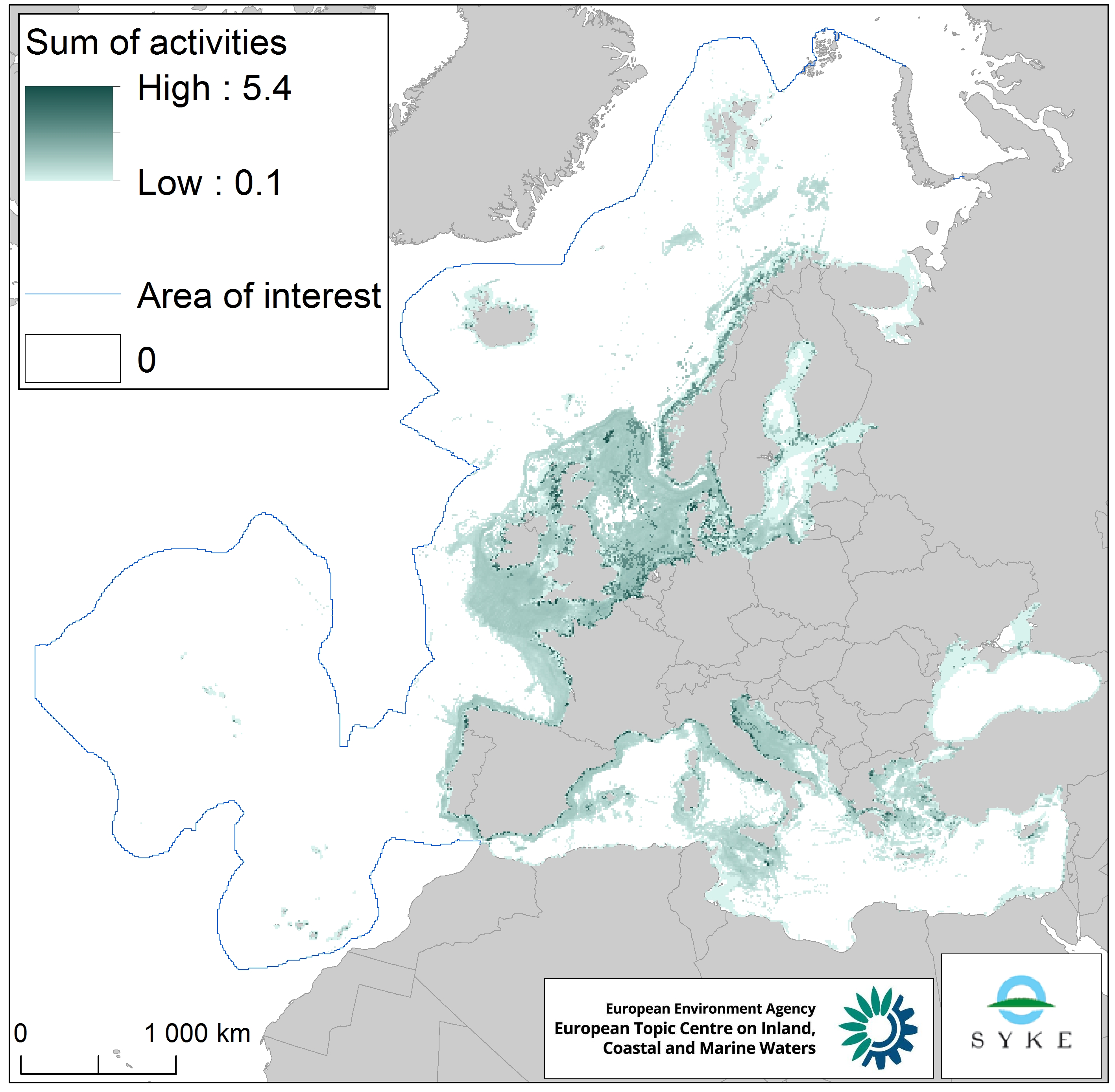
Physical disturbance to seabed in Europe Seas, Jan. 2020
This raster dataset represents physical disturbance to the seabed in the European seas. Several human activities disturb the seabed either directly or indirectly. Alteration of benthic living conditions as a result of increased sedimentation or attenuation of light penetration, abrasion of the seabed and exploitation of benthic biota, temporarily disturb the benthic habitat quality.
The dataset is an aggregation of several different human activities that cause physical disturbance to the seabed: aquaculture, demersal fishing, dredging and dumping of dredged material, oil and gas rigs, offshore installations, ports, sand and gravel extraction, shellfish mariculture, shipping in shallow waters and windfarms. The resulting dataset is a raster (10km grid cell) derived from EMODnet, MED-IAMER, JRC-STECF, OSPAR, HELCOM and 4C Offshore datasets, and with reference temporal coverage from 2012 to 2017.
This dataset has been prepared for the calculation of the combined effect index, produced for the ETC/ICM Report 4/2019 "Multiple pressures and their combined effects in Europe's seas" available on: https://www.eionet.europa.eu/etcs/etc-icm/etc-icm-report-4-2019-multiple-pressures-and-their-combined-effects-in-europes-seas- 1.
|
|
Citation proposal
European Environment Agency (2020) . Physical disturbance to seabed in Europe Seas, Jan. 2020. https://services.mspdata.eu:/geonetwork/srv/api/records/84b01013-692f-4342-bd75-28a0225848c2 |
Simple
- Date ( Creation )
- 2019-05-01
- Date ( Publication )
- 2020-01-27
- Edition
-
01.00
- Identifier
-
eea_r_3035_10_km_physical-disturbance_p_2012-2017_v01_r00
Point of contact
Point of contact
Custodian
- Maintenance and update frequency
- As needed
- GEMET - INSPIRE themes, version 1.0 ( Theme )
-
- Oceanographic geographical features
- Keywords
-
- Keywords
-
- GEMET ( Theme )
-
-
dredged material
,sand extraction
,oil extraction
,pressure
,sea
,fishery
,dredging
,fishing
,harbour
,wind power
,sea bed
,aquaculture
,shellfish
,environmental pressure
,gravel extraction
-
- Continents, countries, sea regions of the world. ( Place )
-
-
Kattegat
,Barents Sea
,Bay of Biscay
,Celtic Sea
,Ionian Sea
,Norwegian Sea
,North Sea
,Baltic Sea
,Northeast Atlantic Ocean (40W)
,Iceland Sea
,English Channel
,Adriatic Sea
,Mediterranean Sea
,Black Sea
-
- Spatial scope ( Theme )
-
-
European
-
- Temporal resolution ( Temporal )
-
- EEA topics ( Theme )
-
-
Biodiversity
,Fisheries and aquaculture
,Production and consumption
,Industry
,Seas and coasts
-
- Sous-regions marines ( Place )
-
-
/Métropole
,/Métropole/Manche mer du Nord
,/Métropole/Mers Celtiques
,/Métropole/Golfe de Gascogne
,/Métropole/Méditerranée occidentale
-
- Thématiques - SIMM ( Theme )
-
-
/Activités et Usages/Industrie et énergie
-
- Thématiques - SIMM ( Theme )
-
-
/Activités et Usages/Pêche et Aquaculture
-
- Thématiques - SIMM ( Theme )
-
-
/Activités et Usages/Transport maritime et Ports
-
- Thématiques - SIMM ( Theme )
-
-
/Etat du Milieu/Espèces
-
- Thématiques - SIMM ( Theme )
-
-
/Etat du Milieu/Géologie
-
- Thématiques - SIMM ( Theme )
-
-
/Etat du Milieu/Hydrodynamique
-
- Type de jeux de donnée - ODATIS ( Theme )
-
-
/Données dérivées/Produits composites
-
- Access constraints
- Other restrictions
- Use constraints
- Other restrictions
- Other constraints
-
License CC-BY 4.0 ( https://creativecommons.org/licenses/by/4.0/ ). Copyright holder: European Environment Agency (EEA).
- Spatial representation type
- grid Grid
- Distance
- 10 km
- Metadata language
- English
- Topic category
-
- Environment
- Oceans
))
- Distribution format
-
-
GeoTIFF
()
-
- OnLine resource
- https://sdi.eea.europa.eu/webdav/datastore/public/eea_r_3035_10_km_physical-disturbance_p_2012-2017_v01_r00/
- OnLine resource
- Direct download
- Hierarchy level
- Dataset
Conformance result
- Date ( Publication )
- 2010-12-08
- Explanation
-
See the referenced specification
- Statement
-
The dataset was created by combining 9 different human activities layers:
1. Aquaculture (EMODnet: https://www.emodnet-humanactivities.eu/search-results.php?dataname=Finfish+Production , MED-IAMER: https://www.msp-platform.eu/projects/med-iamer-integrated-actions-mitigate-environmental-risks-mediterranean-sea )
2. Demersal fishing (European Commission’s Joint Research Centre - Independent experts of the Scientific, Technical and Economic Committee for Fisheries (JRC STECF), OSPAR, HELCOM, see "Bycatch by bottom touching mobile gears in Europe Seas, Jan. 2020")
3. Dredging and dumping of dredged material (EMODnet Human Activities: https://www.emodnet-humanactivities.eu/search-results.php?dataname=Dredging , https://www.emodnet-humanactivities.eu/search-results.php?dataname=Dredge+Spoil+Dumping+%28Points%29 , https://www.emodnet-humanactivities.eu/search-results.php?dataname=Dredge+Spoil+Dumping+%28Polygons%29 )
4. Oil and gas rigs, offshore installations (EMODnet: https://www.emodnet-humanactivities.eu/search-results.php?dataname=Offshore+Installations , MED-IAMER: https://www.msp-platform.eu/projects/med-iamer-integrated-actions-mitigate-environmental-risks-mediterranean-sea )
5. Ports (based on EMODnet vessel density 2017, see: https://www.emodnet-humanactivities.eu/search-results.php?dataname=Vessel+Density+ )
6. Sand and gravel extraction (EMODnet Human Activities: https://www.emodnet-humanactivities.eu/search-results.php?dataname=Aggregate+Extraction+Points )
7. Shellfish mariculture (EMODnet: https://www.emodnet-humanactivities.eu/search-results.php?dataname=Shellfish+Production , MED-IAMER: https://www.msp-platform.eu/projects/med-iamer-integrated-actions-mitigate-environmental-risks-mediterranean-sea )
8. Shipping in shallow waters (based on EMODnet vessel density 2017 - see: https://www.emodnet-humanactivities.eu/search-results.php?dataname=Vessel+Density+ , and EMODnet bathymetry 2016 - see: https://portal.emodnet-bathymetry.eu/ )
9. Windfarms (4C Offshore database: https://www.4coffshore.com/windfarms/ )
Most activity layers were in presence/ absence (1/0) format, except for the demersal fishing and shipping in shallow waters layers which depicted the intensity of the pressure (i.e. the scale was 0–1 after normalization). All human activities layers were normalized and then summed into one raster. The temporal extent varies between the data sources.
- Source
-
- fff43204-793a-4a44-96f7-918672a2047d
- https://www.emodnet-humanactivities.eu/search-results.php?dataname=Finfish+Production
- https://www.msp-platform.eu/projects/med-iamer-integrated-actions-mitigate-environmental-risks-mediterranean-sea
- https://www.emodnet-humanactivities.eu/search-results.php?dataname=Dredging
- https://www.emodnet-humanactivities.eu/search-results.php?dataname=Dredge+Spoil+Dumping+%28Points%29
- https://www.emodnet-humanactivities.eu/search-results.php?dataname=Dredge+Spoil+Dumping+%28Polygons%29
- https://www.emodnet-humanactivities.eu/search-results.php?dataname=Offshore+Installations
- https://www.emodnet-humanactivities.eu/search-results.php?dataname=Vessel+Density+
- https://www.emodnet-humanactivities.eu/search-results.php?dataname=Aggregate+Extraction+Points
- https://www.emodnet-humanactivities.eu/search-results.php?dataname=Shellfish+Production
- https://portal.emodnet-bathymetry.eu/
Metadata
- File identifier
- 84b01013-692f-4342-bd75-28a0225848c2 XML
- Metadata language
- English
- Character set
- UTF8
- Hierarchy level
- Dataset
- Date stamp
- 2025-10-09T11:01:05.186496Z
- Metadata standard name
-
ISO 19115/19139
- Metadata standard version
-
1.0