 Metadata catalogue
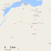
Soil samples collected in April 2001 from Adjumani refugee area, Uganda
This dataset holds different soil samples from the refugee area Adjumani in the North of Uganda. We collected and analyzed the samples during the project Framework for Assessing, Monitoring and Evaluating the environment in refugee-related operations (FRAME) in 2001.
|
|
Citation proposal
. Soil samples collected in April 2001 from Adjumani refugee area, Uganda. https://services.mspdata.eu:/geonetwork/srv/api/records/7c2dfd29-b232-4d3a-b546-776804f1227a |
Simple
- Date ( Creation )
- 2017-05-16
- Identifier
- FRAME_SOIL_SAMPLES_AJ
- Credit
- Lutherian World Federation (LWF) in Adjumani
- Status
- Completed
Point of contact
Point of contact
Point of contact
- Maintenance and update frequency
- Not planned
- GEMET - INSPIRE themes, version 1.0 INSPIRE themes ( Theme )
-
- Soil
- GEMET - Concepts, version 2.4 ( Theme )
-
- soil analysis , soil profile , soil resource
- Geounits ( Place )
-
- Africa , Uganda , Eastern Africa
- Keywords
-
- local coverage , Project FRAME , 4pour1000
- Keywords ( Place )
-
- Adjumani
- Use limitation
- Disclaimer - While every effort has been made to ensure that these data are accurate and reliable within the limits of the current state of the art, IRD cannot assume liability for any damages caused by any errors or omissions in the data, nor as a result of the failure of the data to function on a particular system. IRD makes no warranty, expressed or implied, nor does the fact of distribution constitute such a warranty.
- Access constraints
- Other restrictions
- Other constraints
- Please, get in touch with a point of contact.
- Classification
- Unclassified
- Spatial representation type
- Vector
- Denominator
- 5000
- Metadata language
- eng
- Character set
- UTF8
- Topic category
-
- Geoscientific information
N
S
E
W
))
- Supplemental Information
- Reference system identifier
- EPSG / WGS 84 (EPSG:4326) / 7.9
- Distribution format
-
- CSV (1.0 )
- OnLine resource
-
FRAME_soils_Adjumani.pdf
Adjumani soil analysis
- Hierarchy level
- Dataset
- Statement
- 1. We used a Garmin Etrex GPS to locate the samples
Metadata
- File identifier
- 7c2dfd29-b232-4d3a-b546-776804f1227a XML
- Metadata language
- eng
- Character set
- UTF8
- Hierarchy level
- Dataset
- Hierarchy level name
- Dataset
- Date stamp
- 2017-07-11T10:46:40
- Metadata standard name
- ISO 19115:2003/19139
- Metadata standard version
- 1.0
Point of contact
Point of contact
Overviews
thumbnail

large_thumbnail
Provided by

Associated resources
Not available