Metadata catalogue
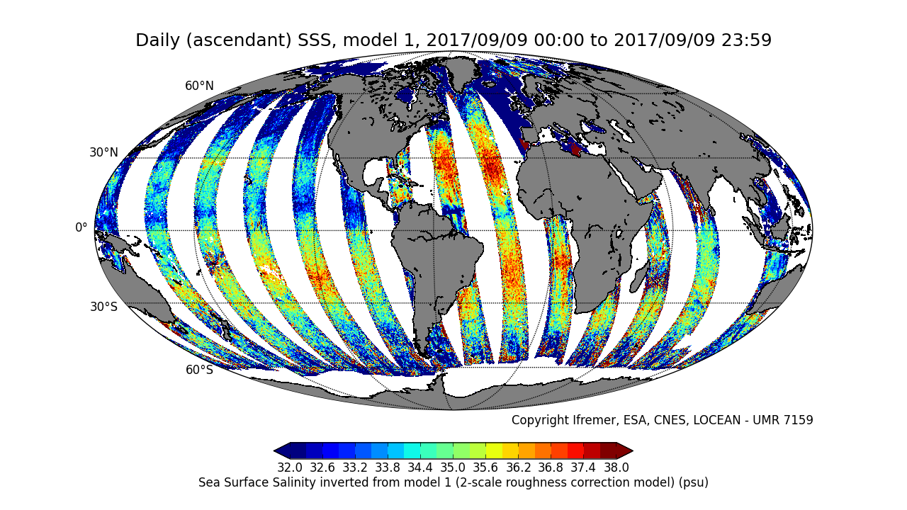
CATDS-PDC L3OS 2P - Daily valid ocean salinity values product from SMOS satellite
This product is an intermediate product, that provides, in daily files, SSS with qualification flags (associated confidence classes) which allow selecting valid data before averaging. Ascending and descending orbits are processed separately
** This product is no longer available, see below **
|
|
Citation proposal
CATDS (2017) . CATDS-PDC L3OS 2P - Daily valid ocean salinity values product from SMOS satellite. CATDS (CNES, IFREMER, LOCEAN) https://services.mspdata.eu:/geonetwork/srv/api/records/77edd308-4296-4774-b6f3-5b38301cee18 |
Simple
- Date ( Publication )
- 2017-05-24
- Date
- Identifier
- CATDS-PDC_L3OS_2P
- Identifier
- DOI:10.12770/77edd308-4296-4774-b6f3-5b38301cee18
- Credit
- CATDS (CNES, IFREMER, LOCEAN)
Author
Principal investigator
Publisher
- Thèmes Sextant ( Theme )
-
- /Imagery/Satellite Imagery
- GEMET - INSPIRE themes, version 1.0 ( Theme )
-
- Orthoimagery
- Keywords ( Theme )
-
- SMOS , CATDS , CPDC , L3OS , Ocean Salinity , 2P , Ocean Product
- Use limitation
- Creative Commons license to apply : Attribution (BY) : http://creativecommons.org/licenses/?lang=en
- Access constraints
- License
- Use constraints
- License
- Other constraints
- Spatial representation type
- Grid
- Denominator
- 1
- Metadata language
- English
- Character set
- UTF8
- Topic category
-
- Geoscientific information
))
- Reference system identifier
- EPSG / WGS 84 / NSIDC EASE-Grid 2.0 Global (EPSG:6933) / 8.6
- Number of dimensions
- 3
- Dimension name
- Column
- Dimension size
- 1388
- Dimension name
- Vertical
- Dimension size
- 584
- Dimension name
- Sample
- Dimension size
- 14
- Cell geometry
- Area
- Transformation parameter availability
- false
- Distribution format
-
- NetCDF (netcdf 3 with 64 bit offset option )
- OnLine resource
-
ATBD L3OS
Algorithm Theoretical Basis Document L3OS
- OnLine resource
- Pros/cons table
- OnLine resource
-
CATDS Sipad
CATDS Sipad - Web-based interactive tool which allows subsettings and temporal agregation.
- OnLine resource
-
CATDS Web portal
CATDS Web portal
- OnLine resource
-
DOI of the dataset
DOI of the dataset
- Hierarchy level
- Dataset
- Statement
-
This product is no longer available. Instead, we recommend to use the product CATDS-PDC L3OS 2Q - Debiased daily valid ocean salinity values product from SMOS satellite (https://doi.org/10.12770/12dba510-cd71-4d4f-9fc1-9cc027d128b0). However, if the L3OS 2Q product doesn't fit your need, and you really need access to the L3OS 2P product, please send us a message with the appropriate justification at support@catds.fr.
The base products, for all the CATDS-PDC (Centre Aval de Traitement des Données SMOS - Production & Dissemination Center) processing chains, are the SMOS L1B products from ESA (European Space Agency).
From these, brightness temperatures at various incidence angles are reconstructed. The Sea Surface Salinity (SSS) are retrieved from multi-angular brightness temperatures through a maximum likehood Bayesian approach in which measured Tb and Tb simulated using a forward direct model are compared (see Zine et al. 2008 for a general description of the retrieval method, and pro_con table for a summary of the similarities/differences with respect to ESA level 2 ocean salinity processing).
The L3OS 2P product is an intermediate product, that provides, in daily files, SSS with qualification flags (associated confidence classes) which allow selecting valid data before averaging. Ascending and descending orbits are processed separately.
Products from reprocessing RE05 are available for the period 01/2010 - 03/2017. Products from operational (OPER) processing are available since 04/2017. Reprocessed products and operational products are derived using the same algorithm and configuration, hence ensuring the temporal continuity.
Note that Dual Polarisation (DP) configuration was used only during the commissioning phase (CP ; 01/2010 - 05/2010), alternately to Full Polarisation (FP) configuration.In order to ensure similar number of retrievals and errors on SSS maps during CP and after CP, DP and FP maps need to be averaged.
File naming :
SM_clas_MIR_CSp2Px_startdate_enddate_vvv_ccc_7
- clas : File class (OPER : operational mode, REXX : reprocessing xx)
- p : F for full polarization, D for dual polarization
- x : A for ascending orbit, D for descending orbit
- startdate : sensing start date/time of the data (format yyyymmddThhmiss)
- enddate : sensing end date/time of the data (format yyyymmddThhmiss)
- vvv : version number of the processor generating the product
- ccc : file counter
File format :
In each archive file (.tgz extension), there are two files
- A Header file (.HDR), which is a text file, in XML Earth Explorer Header format
- A Data file (.DBL.nc), which is a netcdf file, format variant 2 (netcdf 3 with 64 bits offset option)
Reference :
Zine, S., J. Boutin, J. Font, N. Reul, P. Waldteufel, C. Gabarró, J. Tenerelli, F. Petitcolin, J. L. Vergely, M. Talone, and S. Delwart (2008), Overview of the SMOS sea surface salinity prototype processor, IEEE T. Geosci. Remote Sensing, 46, 621-645.
Metadata
- File identifier
- 77edd308-4296-4774-b6f3-5b38301cee18 XML
- Metadata language
- English
- Character set
- UTF8
- Hierarchy level
- Dataset
- Date stamp
- 2019-10-14T16:55:58
- Metadata standard name
- ISO 19115:2003/19139 - SEXTANT
- Metadata standard version
- 1.0