Metadata catalogue
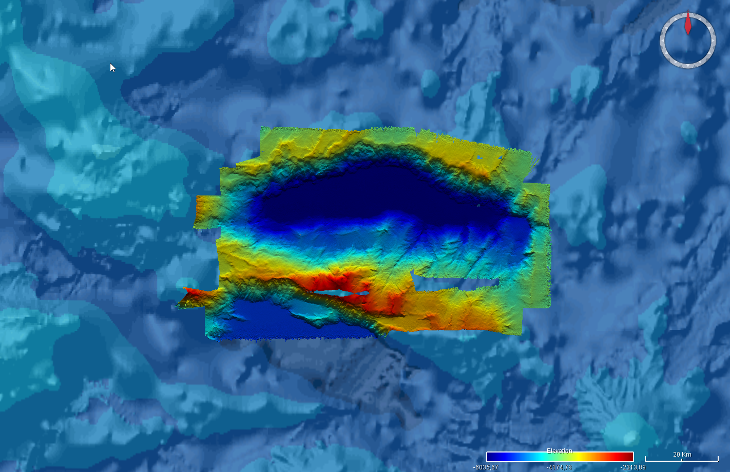
Bathymétrie - Atlantique, Peake Deep (Campagne ESSULYX-PP-2023-2, 2023)
Bathymétrie de la dépression Peake Deep, dans l'océan Atlantique, au pas de 50 mètres. Ce jeu de données est un Modèle Numérique de Terrain bathymétrique, issu de l'acquisition acoustique du sondeur multifaisceaux SB7150 (12kHz) du N/O Pourquoi pas ?.
Référence verticale : Niveau des plus basses mers (PBMA/LAT) - Globe
Rapport de traitement : Pierre Delphine (2023). Campagne ESSULYX23B. Septembre 2023. REM/GEOOCEAN/ANTIPOD. https://doi.org/10.13155/99015
Description de la campagne : BRIGNONE Lorenzo (2023) ESSULYX-PP-2023-2 cruise, RV Pourquoi pas ?, https://doi.org/10.17600/18003469
|
|
Citation proposal
Ifremer Geo-Ocean (Ifremer) (2024) . Bathymétrie - Atlantique, Peake Deep (Campagne ESSULYX-PP-2023-2, 2023). Ifremer https://services.mspdata.eu:/geonetwork/srv/api/records/68a514d7-602b-41a2-bd88-aa337b1c2251 |
Simple
- Date ( Publication )
- 2024-04-30
- Date ( Creation )
- 2023-10-18
- Identifier
- FR-330715-368-00032-EssulyxPP2023_2_PeakeDeep_50m_BATHY
- Credit
- Ifremer
Author
Publisher
Point of contact
- Thèmes Sextant Thèmes Sextant ( Theme )
-
- /Milieu physique/Bathymétrie
- GEMET - INSPIRE themes, version 1.0 GEMET - INSPIRE themes, version 1.0 ( Theme )
-
- Altitude
- GEMET - Concepts, version 2.4 GEMET - Concepts, version 2.4 ( Theme )
-
- géomorphologie , fond marin
- Keywords ( Discipline )
-
- Bathymétrie
- Use limitation
- Données publiques, réservées à l’Ifremer pour un usage interne pendant 2 ans.
- Access constraints
- Restricted
- Use constraints
- Restricted
- Other constraints
- Use limitation
- Ne pas utiliser pour la navigation
- Spatial representation type
- grid Grid
- Denominator
- 100000
- Distance
- 50 meter
- Metadata language
- French
- Character set
- utf8 UTF8
- Topic category
-
- Oceans
))
- Codespace
- EPSG
- Version
- 7.4
Spatial representation info
- Number of dimensions
- 2
- Dimension name
- Column
- Dimension size
- 2075
- Dimension name
- Row
- Dimension size
- 1197
- Cell geometry
- Area
- Distribution format
-
- GeoTIFF (1.0 )
- OnLine resource
-
EssulyxPP2023_2_PeakeDeep_50m_BATHY
EssulyxPP2023_2_PeakeDeep_50m_BATHY
- OnLine resource
-
EssulyxPP2023_2_PeakeDeep_50m_BATHY
EssulyxPP2023_2_PeakeDeep_50m_BATHY
- Protocol
- COPYFILE
- Name
- EssulyxPP2023_2_PeakeDeep_50m_BATHY
- Description
- EssulyxPP2023_2_PeakeDeep_50m_BATHY
- Hierarchy level
- Dataset
Domain consistency
Conformance result
- Date ( Publication )
- 2010-12-08
- Explanation
- See the referenced specification
- Statement
-
Traitements des données acoustiques avec le logiciel GLOBE (Ifremer) :
- Réduction de la marée Prédictions modèle FES2014
- Calibration en roulis
- Filtrage automatique des sondes
- Contrôle qualité manuel
La liste des profils bathymétriques utilisés (format .mbg) est disponible dans le rapport de traitement.
Poncelet Cyrille, Billant Gael, Corre Marie-Paule, Saunier Anthony (2024). Globe (GLobal Oceanographic Bathymetry Explorer) Software. SEANOE. https://doi.org/10.17882/70460
Metadata
- File identifier
- 68a514d7-602b-41a2-bd88-aa337b1c2251 XML
- Metadata language
- French
- Character set
- UTF8
- Hierarchy level
- Dataset
- Date stamp
- 2025-05-15T22:43:42.660923Z
- Metadata standard name
- ISO 19115-3 - SEXTANT ISO 19115-3 - SEXTANT
- Metadata standard version
- 1.0