Metadata catalogue
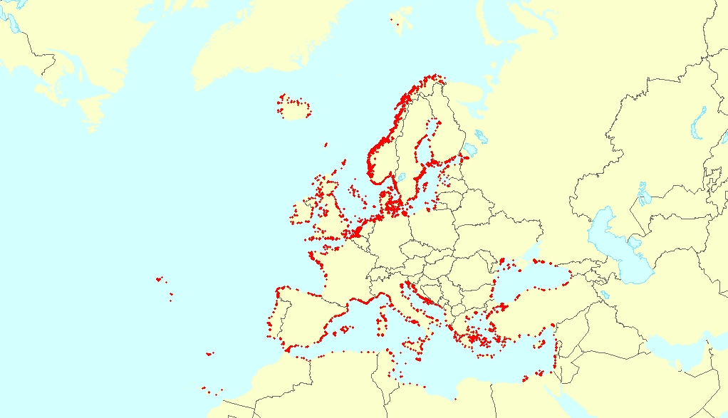
Europe Seas habitats potentially affected by anchoring, Jun. 2020
This vector dataset represents the benthic broad habitat types in Europe seas potentially affected by anchoring.
The anchoring of vessels can produce damages to the seafloor and the loss of the habitat where it happens. It takes place in shallow waters, close to ports, where vessels have to wait for a spot in the port so they can load or offload (since ports have a limited amount of dockage). The anchoring areas allow vessels to safely anchor in protection from bad weather or other circumstances. The type of alterations to the habitats resulting from anchoring depend mainly on the dimensions and type of the anchor, as well as its movement resulting from the movement of the vessel due to currents or waves, which can increase the adverse effects.
The dataset has been prepared in the context of the development of the first European Maritime Transport Environmental Report (to be published as an EMSA-EEA report in 2021).
|
|
Citation proposal
European Environment Agency (2020) . Europe Seas habitats potentially affected by anchoring, Jun. 2020. https://services.mspdata.eu:/geonetwork/srv/api/records/60b9ba8d-f133-4143-962a-f1edb49d2e60 |
Simple
- Date ( Creation )
- 2019-11-01
- Date ( Publication )
- 2020-06-16
- Edition
- 01.00
- Identifier
- eea_v_3035_1_km_anchoring_p_2017_v01_r00
Point of contact
Point of contact
Custodian
- Maintenance and update frequency
- As needed
- GEMET - INSPIRE themes, version 1.0 ( Theme )
-
- Sea regions , Habitats and biotopes
- Keywords
-
- Keywords
-
- GEMET ( Theme )
-
- sea , marine ecosystem , marine environment , habitat loss , benthic ecosystem , environmental quality , aquatic environment , marine biology , environment , ocean
- Continents, countries, sea regions of the world. ( Place )
-
- English Channel , Barents Sea , Bay of Biscay , Ionian Sea , Celtic Sea , Mediterranean Sea , Baltic Sea , North Sea , Adriatic Sea , Kattegat , Northeast Atlantic Ocean (40W) , Norwegian Sea , Black Sea , Iceland Sea
- Spatial scope ( Theme )
-
- European
- EEA topics ( Theme )
-
- Sustainability challenges , Biodiversity , Seas and coasts
- Sous-regions marines ( Place )
-
- /Métropole , /Métropole/Manche mer du Nord , /Métropole/Mers Celtiques , /Métropole/Golfe de Gascogne , /Métropole/Méditerranée occidentale
- Thématiques - SIMM ( Theme )
-
- /Activités et Usages/Transport maritime et Ports
- Thématiques - SIMM ( Theme )
-
- /Etat du Milieu/Habitats
- Thématiques - SIMM ( Theme )
-
- /Etat du Milieu/Pollutions
- Type de jeux de donnée - ODATIS ( Theme )
-
- /Données dérivées/Produits composites
- Access constraints
- Other restrictions
- Use constraints
- Other restrictions
- Other constraints
- License CC-BY 4.0 (https://creativecommons.org/licenses/by/4.0/). Copyright holder: European Environment Agency (EEA).
- Aggregate Datasetindentifier
- aa791cf1-ead5-4364-b0c3-4c54dc83c7e4
- Association Type
- Cross reference
- Spatial representation type
- vector Vector
- Distance
- 1 km
- Denominator
- 2000000
- Metadata language
- English
- Topic category
-
- Environment
- Oceans
))
- Distribution format
-
- SHP ( )
- OnLine resource
- https://sdi.eea.europa.eu/webdav/datastore/public/eea_v_3035_1_km_anchoring_p_2017_v01_r00/
- OnLine resource
- Direct download
- OnLine resource
- https://water.discomap.eea.europa.eu/arcgis/rest/services/Marine/WISE_Marine_EuropeSeasHabitatsPotentiallyAffectedByAnchoring_WM/MapServer
- OnLine resource
- European Maritime Transport Environmental Report 2021
- Hierarchy level
- Dataset
Domain consistency
Conformance result
- Date ( Publication )
- 2010-12-08
- Explanation
- See the referenced specification
- Statement
- The potential anchoring areas have been delineated based on the EMODnet Human Activities Vessel Density Map 2017, considering all ships, and taking the year average value. Cells with especially high density values (i.e. values >= 100) were deemed to most likely represent sites with stationary and idling ships that still had their AIS transponder on. The high value cells were extracted and transformed from raster to polygon format. Since anchoring is unlikely to happen deeper than 100 metres (otherwise it can be difficult to recover the anchor), cells in areas deeper than 100 m were removed (using EMODnet Digital Bathymetry 2016). Furthermore, anchoring areas within 500 metres of main ports (point format) were erased due to these areas likely to being used for docking and other harbour activities, and not anchoring. The ports used are those within the TEN-T network, as well as other ports of relevance (handling more than 1,000,000 tons per year or with a traffic higher than 1,000,000 passengers per year) and main fishing ports (source: LOOP-Ports project). Finally, the resulting layer was overlapped with the EMODnet Broad-Scale Predictive Habitat Map 2019, resulting in the habitats potentially affected by anchoring.
Metadata
- File identifier
- 60b9ba8d-f133-4143-962a-f1edb49d2e60 XML
- Metadata language
- English
- Character set
- UTF8
- Hierarchy level
- Dataset
- Date stamp
- 2025-10-09T10:53:43.679064Z
- Metadata standard name
- ISO 19115/19139
- Metadata standard version
- 1.0