Metadata catalogue
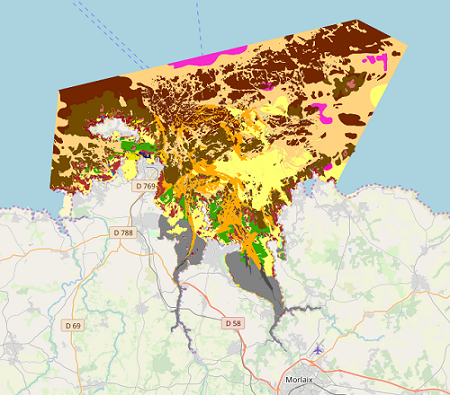
Map of intertidal habitats for the Natura 2000 FR5300015 site – Morlaix Bay
|
|
Citation proposal
Touria Bajjouk Touria Bajjouk (IFREMER IFREMER ) - Anouar Hamdi Anouar Hamdi (Auto-entrepreneur Auto-entrepreneur ) - Bernard Maud Bernard Maud (IFREMER IFREMER ) (2019) . Map of intertidal habitats for the Natura 2000 FR5300015 site – Morlaix Bay. IFREMER IFREMER https://services.mspdata.eu:/geonetwork/srv/api/records/57a9280a-caca-4e89-b2a0-52a2b85f8d5a |
Simple
- Alternate title
- BMO_Synthèse_Natura_Habitats_ZSC_V1r0
- Date ( Revision )
- 2019-03-15T00:00:00
- Date ( Publication )
- 2019-01-01
- Identifier
- FR-330-715-368-00032-SYNTHESE_NATURA2000_FR5300015_MORLAIX
- Identifier
- DOI:10.12770/57a9280a-caca-4e89-b2a0-52a2b85f8d5a
- Presentation form
- Digital map
- Purpose
- The goal of this work is the cartographic habitat characterization of the Natura 2000 Special Area of Conservation (SAC) site in the Bay of Morlaix.
- Credit
- Natura 2000
- Status
- On going
Author
Publisher
- Maintenance and update frequency
- Not planned
- Thèmes Sextant Thèmes Sextant ( Theme )
-
- /Biological Environment/Habitats
- Keywords ( Theme )
-
- Habitat, Intertidal, Typology, Natura 2000, Cartography, Habitats guide, Intertidal zone , Benthique , Natura 2000 , Données ouvertes , Open Data
- Keywords ( Place )
-
- France, Brittany, Finistère, Morlaix, Morlaix Bay , Baie de Morlaix
- GEMET - INSPIRE themes, version 1.0 GEMET - INSPIRE themes, version 1.0 ( Theme )
-
- Habitats and biotopes
- Type de jeux de donnée - ODATIS Type de jeux de donnée - ODATIS ( Theme )
-
- /Processed data/Composite products
- Thématiques - SIMM Thématiques - SIMM ( Theme )
-
- /Etat du Milieu/Habitats
- Use limitation
- Limitation d'utilisation : Utilisation interdite pour un usage commercial. Toute modification de cette donnée est soumise à une autorisation préalable. Pour cela veuillez prendre contact avec le laboratoire LEBCO de l'Unité DYNECO de l'Ifremer.
- Access constraints
- Other restrictions
- Use constraints
- Copyright
- Other constraints
-
Dans la bibliographie et sur les cartes, citation obligatoire de la référence suivante :
Bajjouk T., Hamdi A., Bernard M., 2019. Carte de synthèse des habitats benthiques côtiers du site Natura 2000 FR5300015 - Baie de Morlaix. Produit Ifremer/Dreal Bretagne multi-sources Rebent/Natura2000/Cartham.
- Spatial representation type
- Vector
- Denominator
- 5000
- Metadata language
- French
- Character set
- UTF8
- Topic category
-
- Biota
- Environment description
- ArcGIS 10.0 SP3
- Description
))
- Supplemental Information
-
- SITE: name of the Natura 2000 site
- ZONE: name field areas of the site
- METHOD_NUM: method used for scanning
- SUPP_NUM: Scan media
- DATE_SUPP: date of digital file
- NOM_AUT: name of the polygon's author
- ORG_AUT: organization of the polygon's author
- COM_NUM: miscellaneous comments on polygon digitization
- VALIDATION: specifies whether the polygon has been validated
- METHOD_VAL: specifies the method used to validate
- DATE_VAL: date validation
- NOM_VAL: name of polygon's validator
- PRENOM_VAL: first name of the polygon's validator
- ORG_VAL: Orgisation of polygon's validator
- COM_VAL: various comment on the validation
- CI: confidence index of the polygon (from 1 to 3)
- COD_EUR27: generic habitat code
- LIB_EUR27: generic habitat label
- THEM_EUR27: dominant generic habitat label for a simplified symbology (without mosaic, unrestricted in terms of levels)
- COD_CH2004: elementary habitat codes (habitats guide 2004)
- LIB_CH2004: elementary habitat's label (habitats guide 2004)
- THEM_CH04: dominant elementary habitat's label for a simplified symbology (without mosaic, unrestricted in terms of levels)
- LIB_NP09N1: Level 1 habitat label with the new proposed mapping typology (version 2011).
- THEM_NIV1: Level 1 dominant habitat with the new proposed mapping typology (version 2011).
- LIB_NP09N2: Level 2 habitat label with the new proposed mapping typology(version 2011).
- THEM_NIV2: Level 2 dominant habitat with the new proposed mapping typology (version 2011).
- LIB_NP09N3: Level 3 habitat label with the new proposed mapping typology (version 2011).
- THEM_NIV3: Level 3 dominant habitat with the new proposed mapping typology (version 2011).
- SUBSTRAT : description of the nature of the substrate corresponding to the polygon
- BIOCENOSE : description of the biota present in the area bounded by the polygon
- SURF_M2 : surface of the polygon m²
- SURF_HA : surface of the polygon ha (hectare)
- COMMENT : How to; Additional information
- Reference system identifier
- EPSG / RGF93 / Lambert-93 (EPSG:2154) / 8.6
- Topology level
- Geometry only
- Geometric object type
- Surface
Distributor
- Name
- ESRI Shapefile
- Version
- 10.0
- OnLine resource
- IFR_HABITATS_BENTHIQUES_MORLAIX_2019_P
- Protocol
- FILE
- Name
- IFR_HABITATS_BENTHIQUES_MORLAIX_2019_P
- Description
- Téléchargement par le panier
- OnLine resource
-
IFR_HABITATS_BENTHIQUES_MORLAIX_2019_P
Téléchargement en WFS
- OnLine resource
-
DOI du jeu de donnée
DOI du jeu de donnée
- Hierarchy level
- Dataset
Conformance result
- Date ( Publication )
- 2010-05-03
- Explanation
- Non évalué
- Pass
- false
- Statement
-
This study was conducted from multiple shapefiles provided by Ifremer
- Delimitation of the Natura 2000 FR5300015 site at the Bay of Morlaix, entitled "AncienneEmpriseNatura2000Lb93.shp"
- The SHOM coastline, in the study area entitled "TraitCoteShom25_extrait.shp"
- Delimitation of the area conducted by Ifremer at Térénez entitled "Emprise_Terenez_rebent.shp" and that of the subtidal area entitled "carte_AEhrhold_morlaix_emprise_approxlb93.shp."
Other files allowed for additional information, such as the one on Brittany seagrass "ifr_suiviHerbier_Bretagne2007_l93.shp"
There are three raster images used for habitat photo-interpretation:
Ortholittorales-2000 (dalle40.ecw and dalle41.ecw), available online on the GeoPortal,
- BD Ortho 2005 (29-2005-0130-2420-LA2E-C07.ecw to 29-2005-0145-2435-LA2E-C07.ecw), belonging to the GEOMER laboratory, in partnership with the CETE Normandy
- Blom-2008 (morlaix_mos_extrait.img) belonging to Ifremer
Metadata
- File identifier
- 57a9280a-caca-4e89-b2a0-52a2b85f8d5a XML
- Metadata language
- French
- Character set
- UTF8
- Hierarchy level
- Dataset
- Date stamp
- 2019-11-27T10:26:29
- Metadata standard name
- ISO 19115:2003/19139 - SEXTANT
- Metadata standard version
- 1.0