 Metadata catalogue
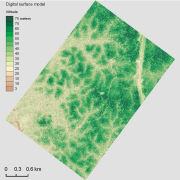
Aerial laser scanning (ALS) dataset, Paracou, French Guiana, acquired on 23 September 2013.
The aerial laser scanning (ALS) dataset acquired on 23 September 2013 covers the experimental station Paracou in French Guiana. The coverage includes all Guyafor and Guyaflux plots completely with logged-over, unlogged and swamp forest ("Pinot" or "Açai").
|
|
Citation proposal
. Aerial laser scanning (ALS) dataset, Paracou, French Guiana, acquired on 23 September 2013.. https://services.mspdata.eu:/geonetwork/srv/api/records/575eabd9-8ef6-402a-a7e3-4f9c2102e809 |
Simple
- Date ( Creation )
- 2013-09-23
- Identifier
- CEBA_ALS_Paracou_23sep2013
- Credit
- SOCIÉTÉ ALTOA
- Status
- Completed
- Maintenance and update frequency
- Not planned
- GEMET - INSPIRE themes, version 1.0 INSPIRE themes ( Theme )
-
- Elevation
- Geounits ( Place )
-
- Americas , South America , France , French Guiana
- GEMET - Concepts, version 2.4 ( Theme )
-
- laser , remote sensing , vegetation cover
- Keywords
-
- local coverage , labex CEBA , Project CANOPOR
- Keywords ( Theme )
-
- aerial laser scanning (ALS)
- Keywords ( Place )
-
- Paracou
- Use limitation
- Please get in touch with a point of contact.
- Access constraints
- Other restrictions
- Other constraints
- Agreement between potential user and point of contact.
- Classification
- Unclassified
- Spatial representation type
- Vector
- Distance
- 0.2236 m
- Metadata language
- eng
- Character set
- UTF8
- Topic category
-
- Elevation
N
S
E
W
))
- Supplemental Information
- Reference system identifier
- EPSG / WGS 84 / UTM zone 22N (EPSG:32622) / 7.9
- Distribution format
-
- tilled LAS files (1.2 )
- OnLine resource
-
ceba_als_paracou_23sep2013_dsm_dc_hs.kmz
Google Earth
- OnLine resource
-
CEBA_ALS_Paracou_23sep2013_grid.zip
Grid shapefile
- Hierarchy level
- Dataset
- Other
- Statement
- 1. All lidar data was acquired by Altoa flying an airplane at the altitude of 600 meters above ground level. The embarked system was composed of a scanning laser altimeter with a rotating mirror mechanism (Riegl LMS-Q560). The wave length used was 1550 nm. The scanning angle was around +/-20°. The laser recorder up to 5 reflected pulse with a nominal precision of 10cm. The mean point density is 15 points/m². 2. Delivery of the data in LAS 1.2 format. 3. The tiled las data are stored in \\forestview01\ALS\Paracou\2013 4. Various further processing steps were carried out. Please get in touch with a point of contact
Metadata
- File identifier
- 575eabd9-8ef6-402a-a7e3-4f9c2102e809 XML
- Metadata language
- eng
- Character set
- UTF8
- Hierarchy level
- Dataset
- Date stamp
- 2017-03-31T11:27:06
- Metadata standard name
- ISO 19115:2003/19139
- Metadata standard version
- 1.0
Point of contact
Overviews
thumbnail

large_thumbnail
Provided by

Associated resources
Not available