Metadata catalogue
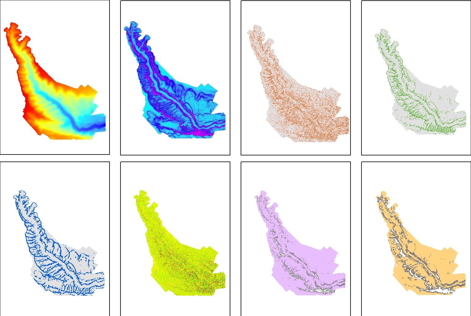
Bathymetry and seafloor variables at 10-m resolution in the Lacaze-Duthiers Canyon, below130 m depth
Seafloor variables were derived from the digital terrain models (DTMs) at a 10-m resolution for the entire canyon. The Lacaze-Duthiers Canyon was first delineated, and only data below 130 m depth were retained.
The dataset is composed of 12 variables : Bathymetry; Slope; Aspect; Curvature; Surface area to Planar area; Vector Ruggedness Measure (VRM) computed using 9, and 25 pixels; and Bathymetric Position Index (BPI) calculated using windows of 3, 9, 25, 49, and 123 pixels.
This dataset was produced to assess the probable distribution of habitats (habitat suitability modeling) for cold-water corals in the Lacaze-Duthiers Canyon at different resolutions as part of the European H2020 project REDRESS (Restoration of Deep-Sea Habitats to Rebuild European Seas, https://redress-project.eu/ , Grant Agreement No. 101135492).
This dataset is related to the article "Mapping and Conservation of Cold-Water Corals in the Lacaze-Duthiers Canyon for Transboundary Management", submitted to Mediterranean Marine Science by Fabri et al. in 2025.
|
|
Citation proposal
Fabri Marie-Claire (IFREMER) - Dreidemy Jeanne (IFREMER) (2025) . Bathymetry and seafloor variables at 10-m resolution in the Lacaze-Duthiers Canyon, below130 m depth. IFREMER https://services.mspdata.eu:/geonetwork/srv/api/records/45218382-4036-4c14-b09c-c3bef3484e80 |
Simple
- Date ( Creation )
- 2024-03-18
- Date ( Publication )
- 2025-03-25
- Identifier
-
LD_Seafloor_variables_10m_under130m
- Credit
-
Ifremer
Author
Centre Méditerranée - Zone Portuaire de Brégaillon - CS20 330 - 83507 La Seyne-sur-Mer Cedex
Toulon
France
Author
Publisher
- Thèmes Sextant ( Theme )
-
-
/Physical Environment/Bathymetry
-
- GEMET - INSPIRE themes, version 1.0 ( Theme )
-
-
Oceanographic geographical features
-
- Access constraints
- Copyright
- Use constraints
- Copyright
- Other constraints
-
Cite the CALADU_2021 oceanograpic cruise ( https://doi.org/10.17600/1800157 5)
- Association Type
- Cross reference
- Initiative Type
- Campaign
- Spatial representation type
- grid Grid
- Distance
- 10 meter
- Metadata language
- English
- Character set
- utf8 UTF8
- Topic category
-
- Oceans
- Environment
))
- Number of dimensions
- 0
- Cell geometry
- Area
- Transformation parameter availability
- false
- Distribution format
-
- ()
- Protocol
-
COPYFILE
- Name
-
Bathymetry_seafloor_variables_10m
- Description
-
Bathymetry and seafloor variables at 10-m resolution
- Function
- Download
- OnLine resource
-
lacaze_seafloor_10m_Aspect
Aspect
- OnLine resource
-
lacaze_seafloor_10m_BATHY
Bathymetry
- OnLine resource
-
lacaze_seafloor_10m_CURV
Curvature
- OnLine resource
-
lacaze_seafloor_10m_SLOPE
Slope
- OnLine resource
-
lacaze_seafloor_10m_S_to_P
Surface area to Planar area
- OnLine resource
-
lacaze_seafloor_10m_VRM25
Vector Ruggedness Measure (VRM) computed using 25 pixels
- OnLine resource
-
lacaze_seafloor_10m_VRM09
Vector Ruggedness Measure (VRM) computed using 9 pixels
- OnLine resource
-
lacaze_seafloor_10m_BPI13-123
Bathymetric Position Index (BPI) calculated using windows of 13 and 123 pixels
- OnLine resource
-
lacaze_seafloor_10m_BPI25
Bathymetric Position Index (BPI) calculated using windows of 25 pixels
- OnLine resource
-
lacaze_seafloor_10m_BPI03
Bathymetric Position Index (BPI) calculated using windows of 3 pixels
- OnLine resource
-
lacaze_seafloor_10m_BPI09
Bathymetric Position Index (BPI) calculated using windows of 9 pixels
- OnLine resource
-
lacaze_seafloor_10m_BPI49
Bathymetric Position Index (BPI) calculated using windows of 49 pixels
- OnLine resource
- Digital Object Identifier (DOI)
- Hierarchy level
- Dataset
Domain consistency
Conformance result
- Date ( Publication )
- 2010-12-08
- Explanation
-
See the referenced specification
- Statement
-
Seafloor indices were derived from a DTM collected during CALADU_2021 cruise using Benthic Terrain Modeler extension in ArcMap 10.7 (ESRI).
Metadata
- File identifier
- 45218382-4036-4c14-b09c-c3bef3484e80 XML
- Metadata language
- English
- Character set
- UTF8
- Hierarchy level
- Dataset
- Date stamp
- 2025-05-16T14:06:51.438872Z
- Metadata standard name
-
ISO 19115-3 - SEXTANT
- Metadata standard version
-
1.0
Author
Centre Méditerranée - Zone Portuaire de Brégaillon - CS20 330 - 83507 La Seyne-sur-Mer Cedex
Toulon
France