Metadata catalogue
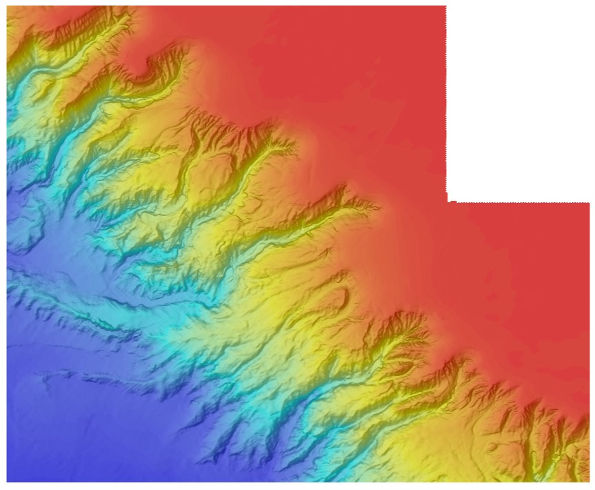
Bathymétrie du canyon de Penmarc'h au canyon de Saint-Nazaire (synthèse, projet CoralFISH, 2012)
Bathymétrie du canyon de Penmarc'h au canyon de Saint-Nazaire, zone BOB2 (synthèse, projet CoralFISH, 2012), au pas de 50 mètres.
Traitements réalisés:
Les données sont issues de :
- BOBGEO1 (2009) : N/O Pourquoi Pas ?, http://dx.doi.org/10.17600/9030060
- BOBGEO2 (2010) : N/O Le Suroît, http://dx.doi.org/10.17600/10020020
- ESSRESON08 (2008) : N/O Pourquoi Pas?, http://dx.doi.org/10.17600/8030070
- ESSNAUT2009(2009) : N/O Pourquoi Pas?, http://dx.doi.org/10.17600/9030020
- VALIDOP (2009) : N/O Atalante, http://dx.doi.org/10.17600/9010030
- ESSINF (2010) : N/O Le Suroit, http://dx.doi.org/10.17600/10020070
- MNTs de la ZEE Atlantique (au pas de 125 m)
Traitements réalisés avec le logiciel ISATIS par Laurent de Chambure, Jean-François Bourillet et Benoît Loubrieu.
|
|
Citation proposal
Bourillet Jean-Francois (IFREMER) - Loubrieu Benoit (IFREMER). Bathymétrie du canyon de Penmarc'h au canyon de Saint-Nazaire (synthèse, projet CoralFISH, 2012). Géosciences Marines (Ifremer) https://services.mspdata.eu:/geonetwork/srv/api/records/44e3e850-5bf3-4d5d-a2b9-d277111f3aae |
Simple
- Date ( Creation )
- 2012-09-03
- Identifier
-
FR-330715-368-00032-BOB2_Gascogne_50m_BATHY
- Identifier
-
DOI:10.12770/44e3e850-5bf3-4d5d-a2b9-d277111f3aae
Point of contact
Point of contact
Point of contact
Point of contact
Centre Bretagne - ZI de la Pointe du Diable - CS 10070 - 29280 Plouzané
Brest
France
- Presentation form
- Digital map
- Credit
-
Ifremer
Author
Centre Bretagne - ZI de la Pointe du Diable - CS 10070 - 29280 Plouzané
Brest
France
Author
Centre Bretagne - ZI de la Pointe du Diable - CS 10070 - 29280 Plouzané
Brest
France
- Maintenance and update frequency
- As needed
- Keywords ( Discipline )
-
-
Bathymétrie
-
- Keywords ( Place )
-
-
Golfe de Gascogne
-
- Keywords ( Temporal )
-
-
2010
-
- GEMET - INSPIRE themes, version 1.0 ( Theme )
-
-
Altitude
-
- GEMET ( Theme )
-
-
Fond marin, morphologie sous-marine
-
- Keywords
-
-
Downloadable Data
-
- Thèmes Sextant ( Theme )
-
-
/Milieu physique/Bathymétrie/MNT
-
- Sous-regions marines ( Place )
-
-
/Métropole/Golfe de Gascogne
-
- Thématiques - SIMM ( Theme )
-
-
/Etat du Milieu/Bathymétrie
,Recherche
-
- Use limitation
-
Ne pas utiliser pour la navigation
- Access constraints
- Other restrictions
- Use constraints
- License
- Other constraints
-
Accès libre
- Spatial representation type
- grid Grid
- Denominator
- 100000
- Metadata language
- French
- Character set
- utf8 UTF8
- Topic category
-
- Elevation
- Environment description
-
Version 6.2 (Build 9200) ; Esri ArcGIS 10.3.1.4959
))
- Reference system identifier
-
EPSG
/WGS84/ WORLD MERCATOR (EPSG3395) latitude 46N
/8.2.6
- Number of dimensions
- 2
- Dimension name
- Column
- Dimension size
- 2258
- Resolution
- 50 m
- Dimension name
- Row
- Dimension size
- 1845
- Resolution
- 50 m
- Cell geometry
- Area
- Transformation parameter availability
- true
- Checkpoint Availability
- false
Center point
- Point in Pixel
-
- centre
- Distribution format
-
-
Raster Dataset
()
-
- OnLine resource
- Campagne BOBGEO
- OnLine resource
- Campagne BOBGEO2
- OnLine resource
- Campagne ESSRESON08-1
- OnLine resource
- Campagne ESSNAUT 2009
- OnLine resource
- Campagne VALIDOP
- OnLine resource
- Campagne ESSINF
- OnLine resource
- BOB2_Gascogne_50m_BATHY
- Protocol
-
COPYFILE
- Name
-
BOB2_Gascogne_50m_BATHY
- OnLine resource
- DOI du jeu de donnée
- Hierarchy level
- Dataset
Domain consistency
Conformance result
- Date ( Publication )
- 2013-12-10
- Identifier
-
D2.8.II.1_v3.0
- Explanation
-
Non évalué
- Pass
- false
- Statement
-
La fusion au pas de grille de 50 mètres a été réalisée dans le cadre du projet CoralFish pour l'édition des travaux "Sur les traces des coraux d'eau froide du golfe de Gascogne / Cartes bathymétriques et géomorphologiques".
Metadata
- File identifier
- 44e3e850-5bf3-4d5d-a2b9-d277111f3aae XML
- Metadata language
- French
- Character set
- UTF8
- Parent identifier
-
71bdca9b-9eac-4e3c-9779-78a62de8cec6
- Hierarchy level
- Dataset
- Hierarchy level name
-
dataset
- Date stamp
- 2025-05-15T22:11:28.309604Z
- Metadata standard name
-
ISO 19115-3 - SEXTANT
- Metadata standard version
-
1.0
Point of contact
Centre Bretagne - ZI de la Pointe du Diable - CS 10070 - 29280 Plouzané
Brest
France