 Metadata catalogue
Simulated altimetry products ocean - Sea Surface Heights - delayed-time - (monomission, along-track, level 3)
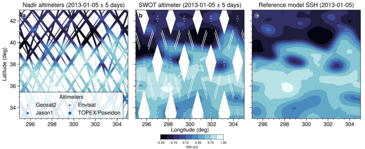
This simulated products "2020A_SSH_MAPPING_NATL60" (SWOT BOOST Data Challenge) are model-based Sea Surface Height (SSH) products and contain Sea Surface Height data simulated on 1) several along-track altimeter orbits (Jason1, Envisat, Geosat2, Topex/Poseidon interleaved and SWOT-nadir orbits - which is not currently in orbit) and 2) the large-swath of SWOT (not currently in orbit). These SSH data are interpolated onto the orbits thanks to the
SWOTSimulator package from a realistic high resolution ocean simulation.
|
|
Citation proposal
(2021) . Simulated altimetry products ocean - Sea Surface Heights - delayed-time - (monomission, along-track, level 3). https://services.mspdata.eu:/geonetwork/srv/api/records/39f2e456-1ae1-4f04-8f4b-9a3e1efcf6d8 |
Simple
- Date ( Publication )
- 2021-01-12
- Date
- Unique resource identifier
- Credit
- CLS-IGE
Point of contact
- Centre de données ODATIS Centre de données ODATIS ( Theme )
-
- CDS-SAT-AVISO
- Variables ODATIS Variables ODATIS ( Theme )
-
- /Physical Oceanography/SSH (Sea surface height)
- Keywords
-
- Type de jeux de donnée ODATIS Type de jeux de donnée ODATIS ( Theme )
-
- /Processed data/Composite products , /Remote sensing
- Thèmatiques ODATIS Thèmatiques ODATIS ( Theme )
-
- Added-value products
- Use limitation
- Licence ouverte Licence ouverte
- Access constraints
- Other restrictions
- Use constraints
- Other restrictions
- Other constraints
-
Conditions of use are described in the Licence : https://www.aviso.altimetry.fr/fileadmin/documents/data/License_Aviso.pdf,
Publications should include the following statement in the Acknowledgments:
“The data used in this study (DOI: 10.24400/527896/a01-2020.002) were developed, validated by CLS and MEOM Team from IGE (CNRS-UGA-IRD-G-INP), France and distributed by CDS-SAT-AVISO”.
- Spatial representation type
- Grid
- Metadata language
- French
- Character set
- UTF8
- Topic category
-
- Oceans
))
- Geometric object type
- Complex
- Distribution format
-
-
( )
-
( )
- OnLine resource
- Further information on AVISO+
- OnLine resource
-
Manuel utilisateur
Manuel utilisateur
- OnLine resource
-
DOI dataset
DOI dataset
- OnLine resource
-
ssh_obs
Along-track TDS fileserver Ocean Data Challenges
- OnLine resource
-
ssh_obs
Gridded TDS NetCDFSubset ODATIS AVISO
- Hierarchy level
- Dataset
- Statement
-
The realistic high-resolution simulation is referenced as the NATL60-CMJ165 simulation based on the NEMO ocean model. The model has a horizontal grid spacing that ranges from 1.6 km at 26°N to 0.9 km at 65°N which allow to simulate realistic SSH scene that could be observed by SWOT.
Use: regional studies; ocean variability (mesoscale circulation), data challenge. For example, it will allow investigating the performance of mapping algorithms with recent and future altimeters constellation, and/or assessing the performances of altimetric missions not currently in orbit (like SWOT mission).
Références:
Code delivery: the open source code is available at https://github.com/ocean-data-challenges/2020a_SSH_mapping_NATL60
- Ajayi A., J. Le Sommer, E. Chassignet, J.-M. Molines, X. Xu, A. Albert, E. Cosme (2020). Spatial and Temporal Variability of the North Atlantic Eddy Field From Two Kilometric‐Resolution Ocean Models. JGR Oceans, https://doi.org/10.1029/2019JC015827.
- Gaultier L., C. Ubelmann, and L.-L. Fu (2016), “The challenge of using future SWOT data for oceanic field reconstruction,” J. Atmos. Ocean. Technol., vol. 33, pp. 119–126, Jan. 2016, https://doi.org/10.1175/JTECH-D-15-0160.1.
- Madec G. and NEMO System Team (2019), “NEMO ocean engine”, Ocean dynamics, Scientific Notes of Climate Modelling Center (27) – ISSN 1288-1619, Institut Pierre-Simon Laplace (IPSL) http://doi.org/10.5281/zenodo.1464816.
- Ocean SWOTsimulator reference manual, https://github.com/SWOTsimulator/swotsimulator/blob/master/doc/source/science.rst
- Ocean SWOTSimulator https://github.com/SWOTsimulator/swotsimulator
- NATL60-CMJ165 simulation https://github.com/meom-configurations/NATL60-CJM165
Metadata
- File identifier
- 39f2e456-1ae1-4f04-8f4b-9a3e1efcf6d8 XML
- Metadata language
- French
- Character set
- UTF8
- Hierarchy level
- Dataset
- Date stamp
- 2021-07-26T16:00:06
- Metadata standard name
- ISO 19115:2003/19139 - SEXTANT
- Metadata standard version
- 1.0
Overviews


Provided by
