Metadata catalogue
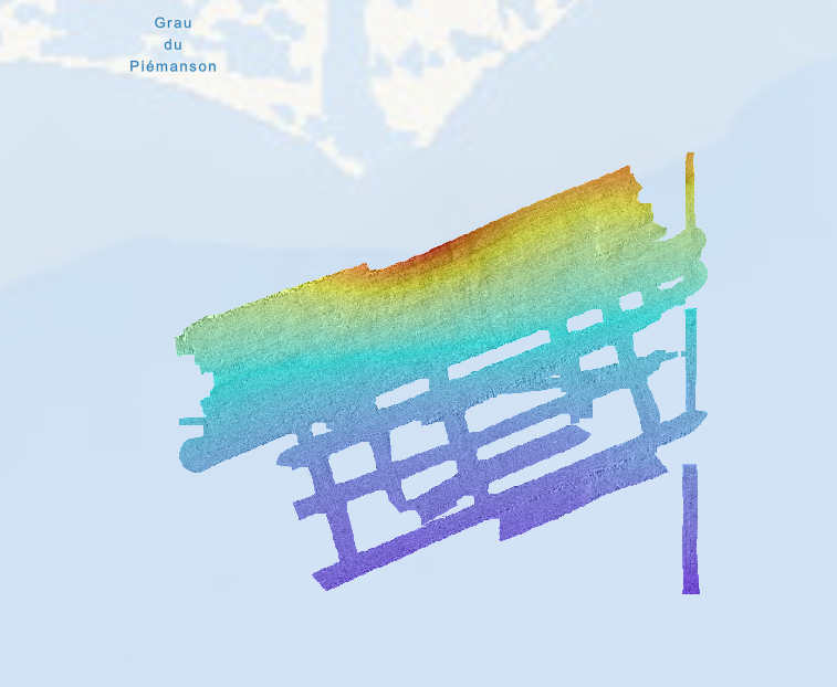
Bathymétrie - golfe du Lion, embouchure du Rhône (campagne RHOSOS, 2008)
Bathymétrie au large de l'embouchure du Rhône (au large des bouées Roustan), dans le golfe du Lion, au pas de 5 mètres. Ce jeu de données est un Modèle Numérique de Terrain bathymétrique, issu de l'acquisition acoustique du sondeur multifaisceaux EM1000 du N/O Le Suroît.
Référence verticale : niveau observé des mers
Description de la campagne : BERNE Serge, DENNIELOU Bernard (2008) RHOSOS cruise, RV Le Suroît, https://doi.org/10.17600/8020040
|
|
Citation proposal
Ifremer Geo-Ocean (Ifremer) (2023) . Bathymétrie - golfe du Lion, embouchure du Rhône (campagne RHOSOS, 2008). Ifremer https://services.mspdata.eu:/geonetwork/srv/api/records/3004e4d4-1b15-4b26-b0a4-3ecbed3cbe56 |
Simple
- Date ( Publication )
- 2023-03-02
- Date ( Creation )
- Date ( Revision )
- 2018-08-07
- Identifier
- FR-330715-368-00032-RHOSOS_Roustan_5m_BATHY
- Credit
- Ifremer / Université de Perpignan Via Domitia
- Status
- completed Completed
Author
Publisher
Point of contact
Point of contact
- Thèmes Sextant Thèmes Sextant ( Theme )
-
- /Milieu physique/Bathymétrie
- GEMET - INSPIRE themes, version 1.0 GEMET - INSPIRE themes, version 1.0 ( Theme )
-
- Altitude
- GEMET - Concepts, version 2.4 GEMET - Concepts, version 2.4 ( Theme )
-
- fond marin , géomorphologie
- Keywords ( Discipline )
-
- Bathymétrie
- Use limitation
- CC BY. Licence Creative Commons Attribution 4.0 International https://creativecommons.org/licenses/by/4.0/
- Access constraints
- Other restrictions
- Use constraints
- License
- Other constraints
- Pas de restriction d'accès public
- Use limitation
- Ne pas utiliser pour la navigation
- Spatial representation type
- grid Grid
- Denominator
- 10000
- Distance
- 5 meter
- Metadata language
- French
- Character set
- utf8 UTF8
- Topic category
-
- Oceans
N
S
E
W
))
- Codespace
- EPSG
- Version
- 7.4
Spatial representation info
No information provided.
- Number of dimensions
- 2
- Dimension name
- Column
- Dimension size
- 2447
- Dimension name
- Row
- Dimension size
- 1861
- Cell geometry
- Area
- Distribution format
-
- GeoTIFF (1.0 )
- OnLine resource
- RHOSOS_Roustan_5m_BATHY
- Protocol
- COPYFILE
- Name
- RHOSOS_Roustan_5m_BATHY
- Description
- OnLine resource
-
RHOSOS_Roustan_5m_BATHY
RHOSOS_Roustan_5m_BATHY
- Hierarchy level
- Dataset
Domain consistency
Conformance result
- Date ( Publication )
- 2010-12-08
- Explanation
- See the referenced specification
- Statement
- Traitement des données par le logiciel Caraibes (développé par l'Ifremer).
Metadata
- File identifier
- 3004e4d4-1b15-4b26-b0a4-3ecbed3cbe56 XML
- Metadata language
- French
- Character set
- UTF8
- Hierarchy level
- Dataset
- Date stamp
- 2025-05-15T21:53:03.129655Z
- Metadata standard name
- ISO 19115-3 - SEXTANT ISO 19115-3 - SEXTANT
- Metadata standard version
- 1.0