Metadata catalogue
Exclusive Economic Zone
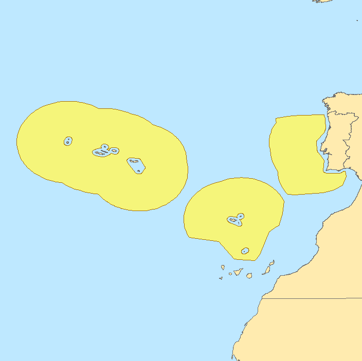
This polygon dataset contains the limits of the exclusive economic zone (EEZ) of Portugal, where Portugal has sovereign rights and jurisdiction. The exclusive economic zone is an area beyond and adjacent to the territorial sea, extending 200 nautical miles from the baselines from which the breadth of the territorial sea is measured. The Portuguese EEZ is divided into three subareas, designated respectively by Subarea 1 (Continental Portugal), Subarea 2 (Madeira) and Subarea 3 (Azores).
|
|
Citation proposal
. Exclusive Economic Zone. https://services.mspdata.eu:/geonetwork/srv/api/records/209cf0fe-ffb1-4db1-abad-2ee0299d53f4 |
Simple
- Alternate title
- ZEE
- Date ( Creation )
- 2011-04-04
- Identifier
- a077ee16-9c65-4a4a-8bea-b230622485b7
- Purpose
- Estes dados são apenas para efeitos de visualização.
- Status
- Concluído Completed
Point of contact
- Website
- http://www.hidrografico.pt
- Maintenance and update frequency
- Não Planeada Not planned
- GEMET - INSPIRE themes, version 1.0 ( Theme )
-
- Unidades administrativas
- Keywords
-
- IH
- Thesaurus SNIMar v.0.x ( parameter )
-
- Zona económica exclusiva - ZEE
- Thesaurus SNIMar v.0.x ( Discipline )
-
- Limites Estabelecidos por Lei ou Convenção
- Classification
- Não Classificado Unclassified
- Use limitation
- Estes dados não substituem as cartas náuticas; não podem ser utilizados para navegação. Para navegação, os navegadores deverão utilizar as Cartas Náuticas publicadas pelo IH.
- Access constraints
- Outras Restrições Other restrictions
- Use constraints
- Direitos de Autor Copyright
- Other constraints
- Descarregamento gratuito. Apenas dados de referência, não oficiais. Não podem ser utilizados para fins comerciais, mas apenas para fins de utilização pessoal e/ou para fins de investigação e deve ser sempre feita referência à sua origem, no caso de serem utilizados na produção de publicações científicas.
- Spatial representation type
- Vectorial Vector
- Denominator
- -1
- Metadata language
- Português Portuguese
- Character set
- utf8 UTF8
- Topic category
-
- Oceans
- Boundaries
N
S
E
W
))
- Reference system identifier
- EPSG / http://www.opengis.net/def/crs/EPSG/0/4326
- Distribution format
-
- Zipped shapefile (N/A )
- Transfer size
- 1.2
- Hierarchy level
- Conjunto de Dados Geográficos Dataset
Conformance result
- Date ( Publication )
- 2010-12-08
- Explanation
- Ver a especificação citada.
- Pass
- false
- Statement
- This dataset comes from the nautical charts produced by the Hydrographic Institute. This dataset was created by the Hydrography Division according to the Decree-Law No. 495/85 of 29 November 1985 and to the Decree-Law No. 119/78 of 01 June 1978 (Portuguese Legislation), and also in accordance to the disposition of the Convention on the Law of the Sea. The outer limit of the EEZ is the line whose points are distant 200 nautical miles from the nearest point of the baselines. These limits were obtained from the NR 1001E nautical chart, produced by the Hydrographic Institute. The data available for free download are only reference data, not official.
- Description
- Carta náutica NR 1001E
Metadata
- File identifier
- 209cf0fe-ffb1-4db1-abad-2ee0299d53f4 XML
- Metadata language
- Português Portuguese
- Character set
- utf8 UTF8
- Hierarchy level
- Conjunto de Dados Geográficos Dataset
- Date stamp
- 2015-12-28
- Metadata standard name
- Perfil SNIMar
- Metadata standard version
- v.0.9.3
Point of contact
- Website
- http://www.hidrografico.pt