Metadata catalogue
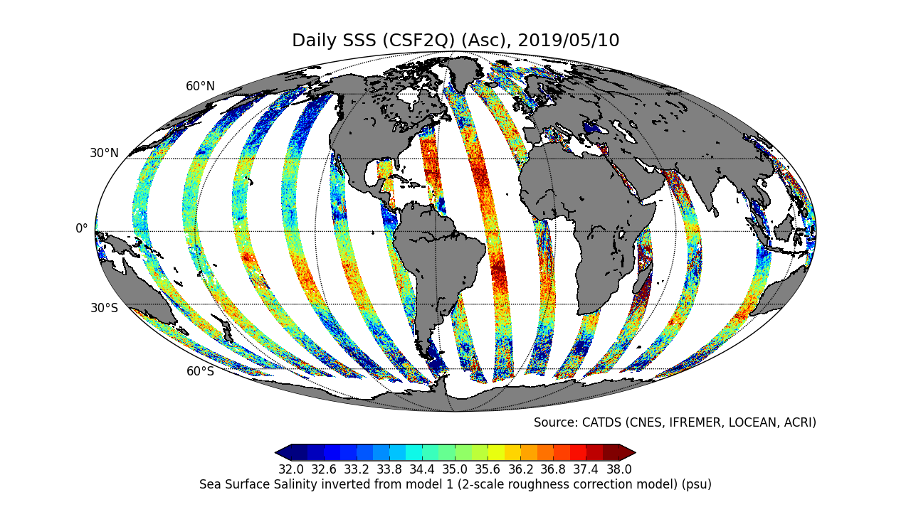
CATDS-PDC L3OS 2Q - Debiased daily valid ocean salinity values product from SMOS satellite
This product is an intermediate product, that provides, in daily files, SSS corrected from land-sea contamination and latitudinal bias. Ascending and descending orbits are processed separately
|
|
Citation proposal
CATDS (2019) . CATDS-PDC L3OS 2Q - Debiased daily valid ocean salinity values product from SMOS satellite. CATDS (CNES, IFREMER, LOCEAN, ACRI) https://services.mspdata.eu:/geonetwork/srv/api/records/12dba510-cd71-4d4f-9fc1-9cc027d128b0 |
Simple
- Date ( Publication )
- 2019-05-17
- Date
- Identifier
-
CATDS-PDC_L3OS_2Q
- Identifier
-
DOI:10.12770/12dba510-cd71-4d4f-9fc1-9cc027d128b0
- Credit
-
CATDS (CNES, IFREMER, LOCEAN, ACRI)
Author
Principal investigator
Publisher
Principal investigator
- Thèmes Sextant ( Theme )
-
-
/Imagery/Satellite Imagery
-
- GEMET - INSPIRE themes, version 1.0 ( Theme )
-
-
Orthoimagery
-
- Keywords ( Theme )
-
-
SMOS
,CATDS
,CPDC
,L3OS
,Ocean Salinity
,2Q
,Ocean Product
-
- Use limitation
-
Creative Commons license to apply : Attribution (BY) : http://creativecommons.org/licenses/?lang=en
- Access constraints
- License
- Use constraints
- License
- Other constraints
- Spatial representation type
- Grid
- Denominator
- 1
- Metadata language
- English
- Character set
- UTF8
- Topic category
-
- Geoscientific information
))
- Reference system identifier
-
EPSG
/WGS 84 / NSIDC EASE-Grid 2.0 Global (EPSG:6933)
/8.6
- Number of dimensions
- 3
- Dimension name
- Column
- Dimension size
- 1388
- Dimension name
- Vertical
- Dimension size
- 584
- Dimension name
- Sample
- Dimension size
- 14
- Cell geometry
- Area
- Transformation parameter availability
- false
- Distribution format
-
-
NetCDF
(netcdf 3 with 64 bit offset option
)
-
- OnLine resource
-
RE06-ASC
RE06-ASC - Reprocessed products (01/2010 - 04/2019), ascending orbits
- OnLine resource
-
RE06-DESC
RE06-DESC - Reprocessed products (01/2010 - 04/2019), descending orbits
- OnLine resource
-
OPER-ASC
OPER-ASC - Operational products (05/2019 - now), ascending orbits
- OnLine resource
-
OPER-DESC
OPER-DESC - Operational products (05/2019 - now), descending orbits
- OnLine resource
-
ATBD L3OS
Algorithm Theoretical Basis Document L3OS
- OnLine resource
- Pros/cons table
- OnLine resource
-
Reference
Boutin J., Vergely J.L., Marchand S., D'Amico F., Hasson A., Kolodziejczyk Nicolas, Reul Nicolas, Reverdin G., Vialard J. (2018). New SMOS Sea Surface Salinity with reduced systematic errors and improved variability. Remote Sensing of Environment, 214, 115-134. Publisher's official version : http://doi.org/10.1016/j.rse.2018.05.0 22 , Open Access version : http://archimer.ifremer.fr/doc/00441/55254/
- OnLine resource
-
CATDS Sipad
CATDS Sipad - Web-based interactive tool which allows subsettings and temporal agregation.
- OnLine resource
- CATDS Web portal
- OnLine resource
- DOI of the product
- Hierarchy level
- Dataset
- Statement
-
The base products, for all the CATDS-PDC (Centre Aval de Traitement des Données SMOS - Production & Dissemination Center) processing chains, are the SMOS L1B products from ESA (European Space Agency).
From these, brightness temperatures at various incidence angles are reconstructed. The Sea Surface Salinity (SSS) are retrieved from multi-angular brightness temperatures through a maximum likehood Bayesian approach in which measured Tb and Tb simulated using a forward direct model are compared (see Zine et al. 2008 for a general description of the retrieval method, and pro_con table for a summary of the similarities/differences with respect to ESA level 2 ocean salinity processing).
The qualified L3OS 2Q product is an intermediate product, that provides, in daily files, SSS corrected from land-sea contamination and latitudinal bias. Ascending and descending orbits are processed separately.
Products from reprocessing RE06 are available for the period 01/2010 - 04/2019. Products from operational (OPER) processing are available since 05/2019. Reprocessed products and operational products are derived using the same algorithm and configuration, hence ensuring the temporal continuity.
These products are generated with a delay of 5 days (Please see below for alternative 1-day delay products).
File naming :
SM_clas_MIR_CSF2Qx_startdate_enddate_vvv_ccc_7
- clas : File class (OPER : operational mode, REXX : reprocessing xx)
- x : A for ascending orbit, D for descending orbit
- startdate : sensing start date/time of the data (format yyyymmddThhmiss)
- enddate : sensing end date/time of the data (format yyyymmddThhmiss)
- vvv : version number of the processor generating the product
- ccc : file counter
File format :
In each archive file (.tgz extension), there are two files
- A Header file (.HDR), which is a text file, in XML Earth Explorer Header format
- A Data file (.DBL.nc), which is a netcdf file, format variant 2 (netcdf 3 with 64 bits offset option)
Alternative 1-day delay products :
Since 07/2019, 1-day delay products are also available, in operational (OPER) processing only.
These products are only available by FTP (i.e. not by Sipad). The paths and file names are identical, except that the "MIR" tags are replaced by "NRT".
Reference :
Boutin J., Vergely J.L., Marchand S., D'Amico F., Hasson A., Kolodziejczyk Nicolas, Reul Nicolas, Reverdin G., Vialard J. (2018). New SMOS Sea Surface Salinity with reduced systematic errors and improved variability. Remote Sensing of Environment, 214, 115-134. Publisher's official version : http://doi.org/10.1016/j.rse.2018.05.0 22 , Open Access version : http://archimer.ifremer.fr/doc/00441/55254/
Metadata
- File identifier
- 12dba510-cd71-4d4f-9fc1-9cc027d128b0 XML
- Metadata language
- English
- Character set
- UTF8
- Hierarchy level
- Dataset
- Date stamp
- 2020-05-29T10:53:43
- Metadata standard name
-
ISO 19115:2003/19139 - SEXTANT
- Metadata standard version
-
1.0
Point of contact
Centre Bretagne - ZI de la Pointe du Diable - CS 10070 - 29280 Plouzané
Brest
France