Metadata catalogue
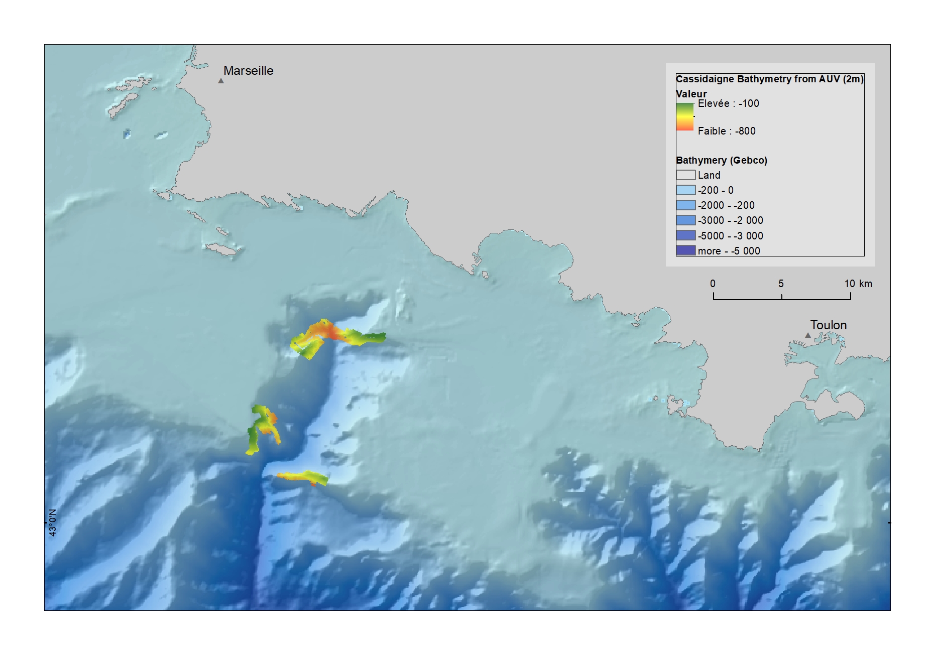
High resolution bathymetry in Cassidaigne canyon (resolution 2 m)
Bathymetric data was collected with a Multi-Beam Echo-Sounder EM2040 mounted on an AUV.
|
|
Citation proposal
Marie-Claire Fabri (Ifremer) (2021) . High resolution bathymetry in Cassidaigne canyon (resolution 2 m). Ifremer centre de Méditerranée https://services.mspdata.eu:/geonetwork/srv/api/records/0e22d4aa-978e-4bc7-aad4-838a4c4fc1de |
Simple
- Date ( Creation )
- 2017-04-09
- Date ( Publication )
- 2021-03-09
- Identifier
-
FR-330-715-368-00032-IFR_MBES_BATHYCOR2_2014_2M
- Credit
-
Ifremer
Author
Publisher
- Thèmes Sextant ( Theme )
-
-
/Milieu physique/Bathymétrie/Isobathes
-
- GEMET - INSPIRE themes, version 1.0 ( Theme )
-
-
Altitude
-
- Cadre Réglementaire - SIMM ( Theme )
-
-
Directive Cadre Stratégie pour le Milieu Marin (DCSMM)
-
- Sous-regions marines ( Place )
-
-
/Métropole/Méditerranée occidentale
-
- Keywords
-
-
Méditerranée
,Cassidaigne
-
- Access constraints
- Other restrictions
- Use constraints
- Copyright
- Other constraints
-
Fabri, M.C., Bargain, A., Pairaud, I., Pedel, L., & Taupier-Letage, I. (2017) Cold-water coral ecosystems in Cassidaigne Canyon: An assessment of their environmental living conditions. Deep Sea Research Part II: Topical Studies in Oceanography, 137, 436-453. https://doi.org/10.1016/j.dsr2.2016.06.006
Fabri, M.-C., Vinha, B., Allais, A.-G., Bouhier, M.-E., Dugornay, O., Gaillot, A., & Arnaubec, A. (2019) Evaluating the ecological status of cold-water coral habitats using non-invasive methods: An example from Cassidaigne canyon, northwestern Mediterranean Sea. Progress in Oceanography, 178, 102172. https://doi.org/10.1016/j.pocean.2019.10217 2
- Association Type
- Cross reference
- Initiative Type
- Platform
- Association Type
- Cross reference
- Initiative Type
- Platform
- Spatial representation type
- vector Vector
- Denominator
- 10000
- Metadata language
- French
- Character set
- utf8 UTF8
- Topic category
-
- Elevation
))
- Distribution format
-
- ()
- OnLine resource
-
compil_bathycor12_2m_blend
Bathymetrie AUV dans Cassidaigne
- Protocol
-
COPYFILE
- Name
-
Bathymetrie 2m Cassadaigne
- Description
-
Bathymetrie 2m Cassadaigne
- OnLine resource
- Digital Object Identifier (DOI)
- Hierarchy level
- Dataset
Domain consistency
Conformance result
- Date ( Publication )
- 2010-12-08
- Explanation
-
See the referenced specification
- Statement
-
Données acquises par le sondeur multifaisceaux Kongsberg 2040 de l'AUV Aster'x en 2014 et en 2016, lors des campagnes Bathycor1_2014 et Bathycor2_2016.
Les données des deux campagnes ont été combinées pour obtenir une couverture la plus large possible à une résolution de 2m sur les zones probables de présence de coraux dans le canyon de Cassidaigne. Les données ont été traitées ont été traitées avec le logiciel GLOBE (développé par Ifremer).
Metadata
- File identifier
- 0e22d4aa-978e-4bc7-aad4-838a4c4fc1de XML
- Metadata language
- French
- Character set
- UTF8
- Hierarchy level
- Dataset
- Date stamp
- 2025-05-15T21:21:39.956269Z
- Metadata standard name
-
ISO 19115-3 - SEXTANT
- Metadata standard version
-
1.0