 Metadata catalogue
Near-bottom bathymetry and back-scatter data acquired with AUV IDEFX during the AMORGOS-22 cruise
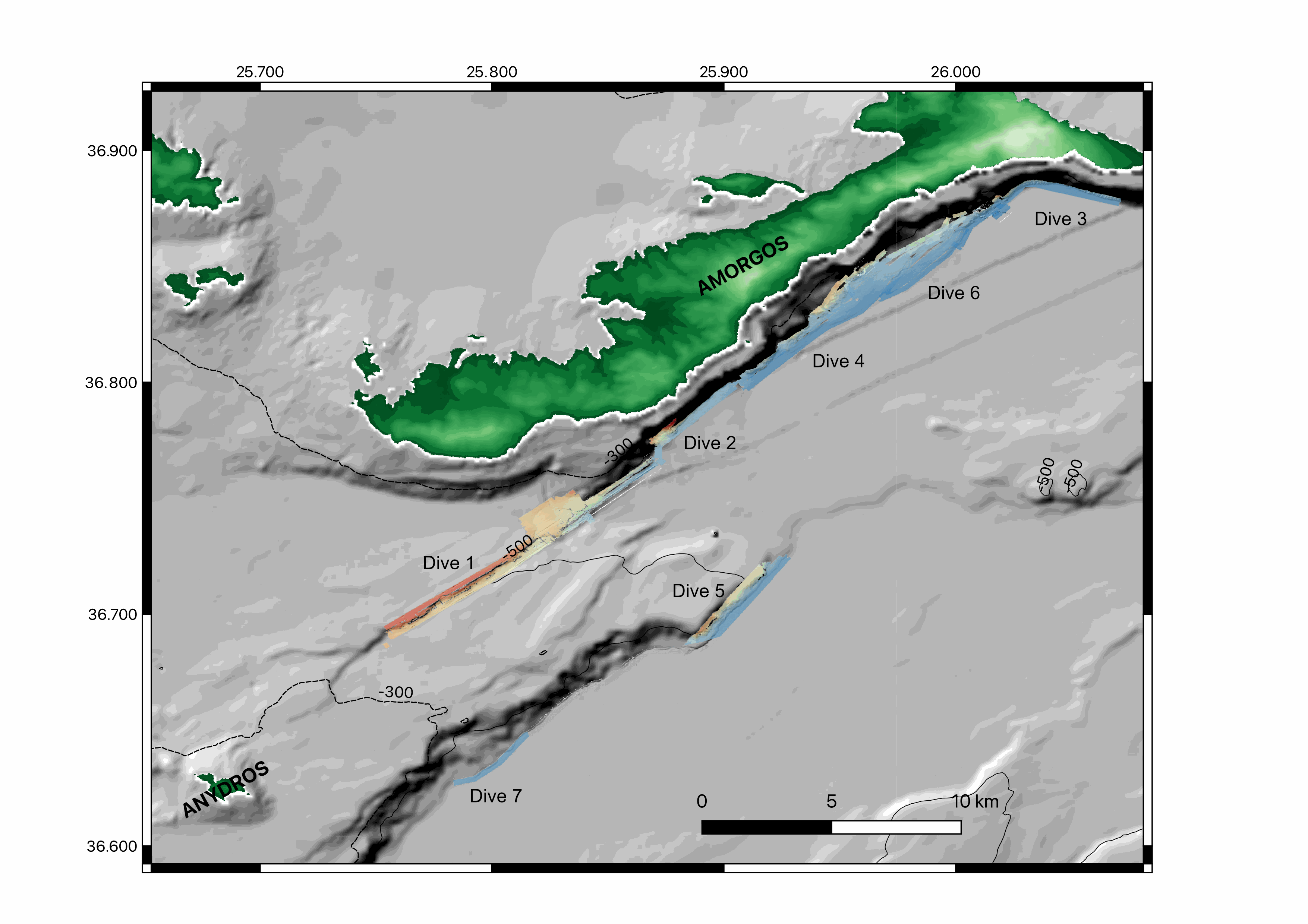
Near-bottom multibeam bathymetry and back-scatter data acquired along the Amorgos and Santorini-Amorgos faults, in the Aegean sea. High-resolution bathymetry data (1 m/pixel) were acquired by the autonomous underwater vehicle (AUV) IdefX, deployed during the AMORGOS-22 cruise ( https://doi.org/10.17600/18001479 ) with the MBES EM2040. The dataset consists of six DEMs as well as fourteen back-scatter mosaics (i.e. two versions for each dives, raw and processed (compention of the antenna diagram)). In addition, a DEM extracted from dive 2 is provided. The bathymetric data were processed with GLOBE, while the back-scatter data were processed with Sonarscope. Renavigation of the vehicule was necessary during processing and is applied to both the bathymetric grids and backscatter mosaics. Files are provided in TIF format, projected in UTM 35 N (WGS 84).
|
|
Citation proposal
LECLERC Frédérique (Université Côte d'Azur, CNRS, Observatoire de la Côte d'Azur, IRD, Géoazur, Valbonne, France) - BARRIERE Paul (Université Côte d'Azur, CNRS, Observatoire de la Côte d'Azur, IRD, Géoazur, Valbonne, France) - NOMIKOU Paraskevi (Department of Geology, University of Athens, Panepistimioupoli Zografou, 157 84 Athens, Greece) - FEUILLET Nathalie (Université de Paris, Institut de physique du globe de Paris, CNRS, F-75005, Paris, France) - LAMPRIDOU Danai (Department of Geology, University of Athens, Panepistimioupoli Zografou, 157 84 Athens, Greece) - ESCARTIN Javier (Laboratoire de Géologie, Ecole Normale Supérieure (CNRS UMR 8538), PSL Research University, Paris, France) (2022) . Near-bottom bathymetry and back-scatter data acquired with AUV IDEFX during the AMORGOS-22 cruise. https://services.mspdata.eu:/geonetwork/srv/api/records/seanoe:99212 |
Simple
- Date ( Publication )
- 2022
- Date ( Revision )
- 2025-04-03
- Other citation details
-
Leclerc Frédérique, Barriere Paul, Nomikou Paraskevi, Feuillet Nathalie, Lampridou Danai, Escartin Javier (2022). Near-bottom bathymetry and back-scatter data acquired with AUV IDEFX during the AMORGOS-22 cruise. SEANOE. https://doi.org/10.17882/99 212
In addition to properly cite this dataset, it would be appreciated that the following work(s) be cited too, when using this dataset in a publication :
Leclerc Frédérique, Palagonia Sylvain, Feuillet Nathalie, Nomikou Paraskevi, Lampridou Danai, Barrière Paul, Dano Alexandre, Ochoa Eduardo, Gracias Nuno, Escartin Javier (2024). Large seafloor rupture caused by the 1956 Amorgos tsunamigenic earthquake, Greece. Communications Earth & Environment, 5(1). https://doi.org/10.1038/s43247-024-01839-0
- Credit
-
F. Leclerc & participants thanks the Flotte océanographique Française, the Commission Nationale de la Flotte Océanographique Côtière, Ifremer and Genavir for their support; the captain and crew of R/V Europe, and the HROV team. We are grateful to CNRS INSU for support and funding. We are thankful to the Minister of Foreign Affairs of Greece for delivering permits to conduct this cruise.
Publisher
- Keywords ( Theme )
-
-
AMORGOS-22
,Bathymetry
,EM2014
,AUV IDEFX
,Amorgos
,AUV
,Faults
,Back-scatter
,Marine geology
-
- ODATIS aggregation parameters and Essential Variable names ( Theme )
-
- Bathymetry
- SeaDataNet Parameter Disciplines ( parameter )
-
- Marine geology
- Research Infrastructure ( Theme )
-
- IR-FOF
- Type de jeux de donnée ODATIS ( Theme )
-
- /Observational data/in-situ
- Use constraints
- Other restrictions
- Other constraints
- Date ( Publication )
- 2024
Publisher
Author
Author
Author
Author
Author
Author
Author
Author
Author
Author
- Association Type
- Cross reference
- Initiative Type
- Study
- Date ( Publication )
- 2023
Publisher
Author
Author
Author
Author
Author
- Association Type
- Cross reference
- Initiative Type
- dataset
- Association Type
- Cross reference
- Initiative Type
- Platform
- Metadata language
- English
- Topic category
-
- Oceans
))
- Distribution format
-
-
TIF
() -
PDF
()
-
- OnLine resource
-
Processed data
Digital Elevation Model gridded at 1 m resolution extracted from dive 297-2, focusing on the Amorgos fault scarp central segment. - 1 MB
- OnLine resource
-
Processed data
Digital Elevation Model gridded at 1 m resolution of AUV dive 302-7 acquired during AMORGOS-22 cruise [RESTRICTED] - 1 MB
- OnLine resource
-
Processed data
Digital Elevation Model gridded at 1 m resolution of AUV dive 300-5 acquired during AMORGOS-22 cruise [RESTRICTED] - 92 MB
- OnLine resource
-
Processed data
Digital Elevation Model gridded at 1 m resolution of AUV dives 299-4 and 301-6, merged, acquired during AMORGOS-22 cruise [RESTRICTED] - 415 MB
- OnLine resource
-
Processed data
Digital Elevation Model gridded at 1 m resolution of AUV dive 298-3 acquired during AMORGOS-22 cruise [RESTRICTED] - 36 MB
- OnLine resource
-
Processed data
Digital Elevation Model gridded at 1 m resolution of AUV dive 297-2 acquired during AMORGOS-22 cruise [RESTRICTED] - 55 MB
- OnLine resource
-
Processed data
Digital Elevation Model gridded at 1 m resolution of AUV dive 296-1 acquired during AMORGOS-22 cruise [RESTRICTED] - 401 MB
- OnLine resource
-
Raw data
Back-scatter mosaic of Dive 302-7, gridded at 1 m. [RESTRICTED] - 234 MB
- OnLine resource
-
Processed data
Back-scatter mosaic of Dive 302-7, compensated from antenna diagram and gridded at 1 m. [RESTRICTED] - 234 MB
- OnLine resource
-
Raw data
Back-scatter mosaic of Dive 301-6 gridded at 1 m. [RESTRICTED] - 379 MB
- OnLine resource
-
Processed data
Back-scatter mosaic of Dive 301-6, compensated from antenna diagram and gridded at 1 m. [RESTRICTED] - 379 MB
- OnLine resource
-
Raw data
Back-scatter mosaic of Dive 300-5 gridded at 1 m. [RESTRICTED] - 88 MB
- OnLine resource
-
Processed data
Back-scatter mosaic of Dive 300-5, compensated from antenna diagram and gridded at 1 m. [RESTRICTED] - 88 MB
- OnLine resource
-
Raw data
Back-scatter mosaic of Dive 299-4 gridded at 1 m. [RESTRICTED] - 297 MB
- OnLine resource
-
Processed data
Back-scatter mosaic of Dive 299-4, compensated from antenna diagram and gridded at 1 m. [RESTRICTED] - 297 MB
- OnLine resource
-
Raw data
Back-scatter mosaic of Dive 298-3 gridded at 1 m. [RESTRICTED] - 34 MB
- OnLine resource
-
Processed data
Back-scatter mosaic of Dive 298-3, compensated from antenna diagram and gridded at 1 m. [RESTRICTED] - 27 MB
- OnLine resource
-
Raw data
Back-scatter mosaic of Dive 297-2 gridded at 1 m. [RESTRICTED] - 53 MB
- OnLine resource
-
Processed data
Back-scatter mosaic of Dive 297-2, compensated from antenna diagram and gridded at 1 m. [RESTRICTED] - 53 MB
- OnLine resource
-
Raw data
Back-scatter mosaic of Dive 296-1 gridded at 1 m. [RESTRICTED] - 393 MB
- OnLine resource
-
Processed data
Back-scatter mosaic of Dive 296-1, compensated from antenna diagram and gridded at 1 m. [RESTRICTED] - 393 MB
- OnLine resource
- DOI of the product
- OnLine resource
- Seanoe
- Hierarchy level
- Dataset
- Statement
-
EM2040 mounted on AUV IDEFX
Metadata
- File identifier
- seanoe:99212 XML
- Metadata language
- English
- Character set
- UTF8
- Hierarchy level
- Dataset
- Date stamp
- 2025-04-03
- Metadata standard name
-
ISO 19115:2003/19139
- Metadata standard version
-
1.0
Overviews
Provided by
