 Metadata catalogue
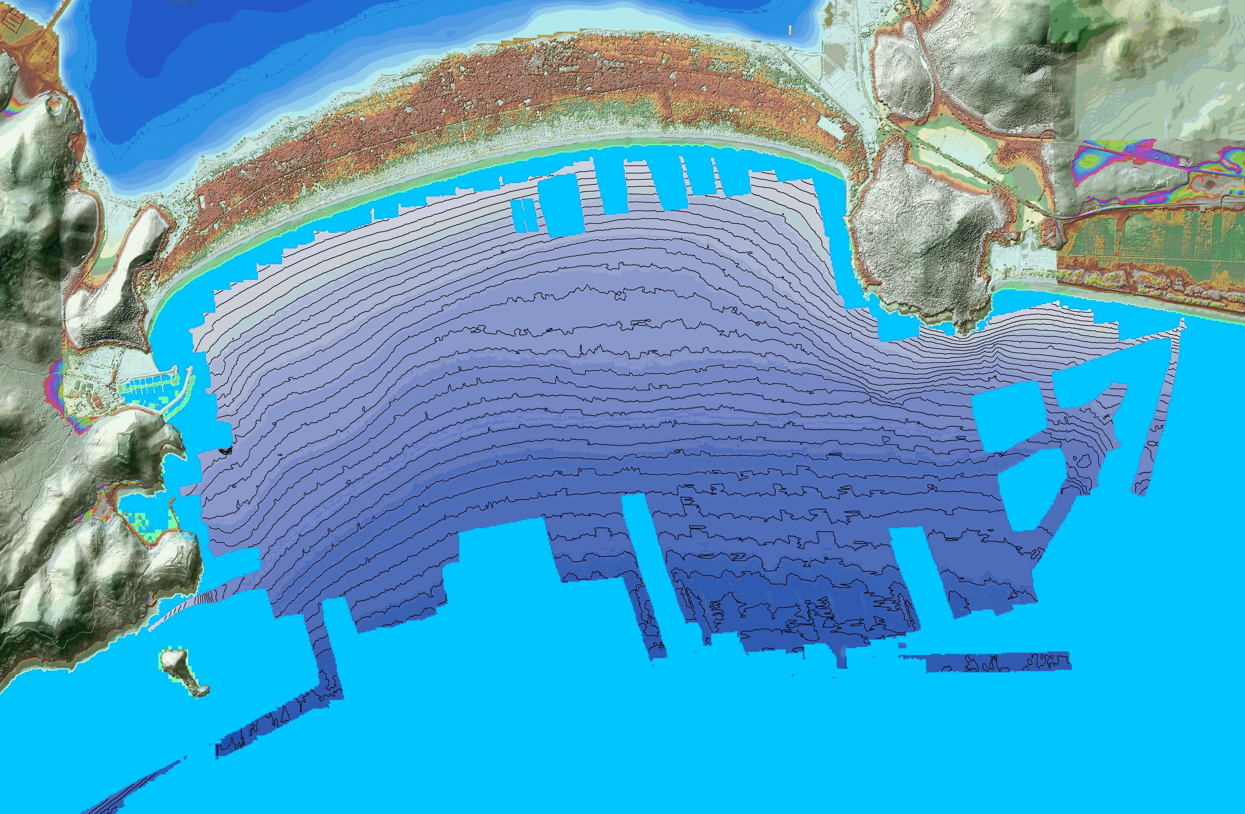
Swath bathymetry of the Gulf of Porto Ercole, Tuscany, Italy
These bathymetric data were produced using the interferometric side-scan sonar onboard the Haliotis Research Vessel, Operated by Genavir, for the French Oceanographic Fleet, in October 2022, during the oceanographic campaign HISOPE (l'Haliotis pour l’Imagerie Sismique d’Orbetello et Pyrgi Etrusques).
The investigated area is located in front of the tombolo di Feniglia, in the Gulf of Porto Ercole. The goal of the campaign was to image the sedimentary architecture of the Tombolo di Feniglia
Acquisition took place from October 1st to October 6th 2022.
Data were acquired by eng. Quentin Layahe, Genavir, onboard the Haliotis, piloted by Serge Garcia, and post-processed using the software Globe, developed by the IFREMER, by Dr.Gilles Brocard (Archéorient, University of Lyon 2, France) and Alessandro Conforti, research engineer at the CNR (Italian national center for research) at Orosi, Sardinia.
|
|
Citation proposal
Brocard Gilles (Archéorient, Maison de l'Orient et de la Méditerranée, University of Lyon 2, France) - Conforti Alessandro (Centro Nazionale della Riserca, Oristano, Sardinia, Italy) (2022) . Swath bathymetry of the Gulf of Porto Ercole, Tuscany, Italy. https://services.mspdata.eu:/geonetwork/srv/api/records/seanoe:95997 |
Simple
- Date ( Publication )
- 2022-10
- Date ( Revision )
- 2024-11-15
- Other citation details
-
Brocard Gilles, Conforti Alessandro (2022). Swath bathymetry of the Gulf of Porto Ercole, Tuscany, Italy. SEANOE. https://doi.org/10.17882/95997
Author
Publisher
- Keywords ( Theme )
-
-
Porto Ercole
,geoswath
,bathymetry
,tuscany
,Italy
,Marine geology
-
- ODATIS aggregation parameters and Essential Variable names ( Theme )
-
- Bathymetry
- SeaDataNet Parameter Disciplines ( parameter )
-
- Marine geology
- Type de jeux de donnée ODATIS ( Theme )
-
- /Observational data/in-situ
- Use constraints
- Other restrictions
- Other constraints
- Date ( Publication )
- 2024
Publisher
Author
Author
Author
Author
Author
Author
Author
Author
Author
Author
Author
Author
Author
Author
Author
Author
- Association Type
- Cross reference
- Initiative Type
- Study
- Date ( Publication )
- 2022
Publisher
Author
Author
Author
Author
- Association Type
- Cross reference
- Initiative Type
- dataset
- Association Type
- Cross reference
- Initiative Type
- Platform
- Metadata language
- English
- Topic category
-
- Oceans
))
- Distribution format
-
-
IMAGE
()
-
- OnLine resource
-
Processed data
Bathymetry of the Gulf of Porto Ercolo at 1 m resolution, projection system WGS 84, UTM zone 32 N (format GeoTIFF) - 240 MB
- OnLine resource
-
Processed data
Bathymetry of the Gulf of Porto Ercole at 10 m resolution, projection system WGS 84, UTM zone 32 N (format GeoTIFF) - 2 MB
- OnLine resource
- DOI of the product
- OnLine resource
- Seanoe
- Hierarchy level
- Dataset
- Statement
-
Interferometric side-scan sonar of the Haliotis
A side-scan sonar builds detailed acoustic images of the seafloor.
The interferometric side-scan sonar comprises a bathymetric function. To make a side-scan sonar interferometric, the height of an echo on the bottom has to be linked to the angle of arrival by accurately measuring the phase difference of the arrival times on the various arrays stacked on either side. By using the true bearing and the slant range (obtained by other means), the position of the sounding points can be established in three dimensions.
The main advantage of an interferometric side-scan sonar over a multibeam sounder is its greater swath width in shallow water. Bathymetric measurements are, however, less accurate than those produced by a multibeam echo sounder and suffer from excessive noise at the end of the range.
The Haliotis is equipped with a Geoswath interferometric sonar fixed rigidly to the hull. The device functions at a frequency of 250 kHz.
Data were post-processed using "Globe (GLobal Oceanographic Bathymetry Explorer) Software." (2019) developed by Cyrille Poncelet, Gael Billant, and Marie-Paule Corre
Metadata
- File identifier
- seanoe:95997 XML
- Metadata language
- English
- Character set
- UTF8
- Hierarchy level
- Dataset
- Date stamp
- 2024-11-15
- Metadata standard name
-
ISO 19115:2003/19139
- Metadata standard version
-
1.0
Overviews
Provided by
