 Metadata catalogue
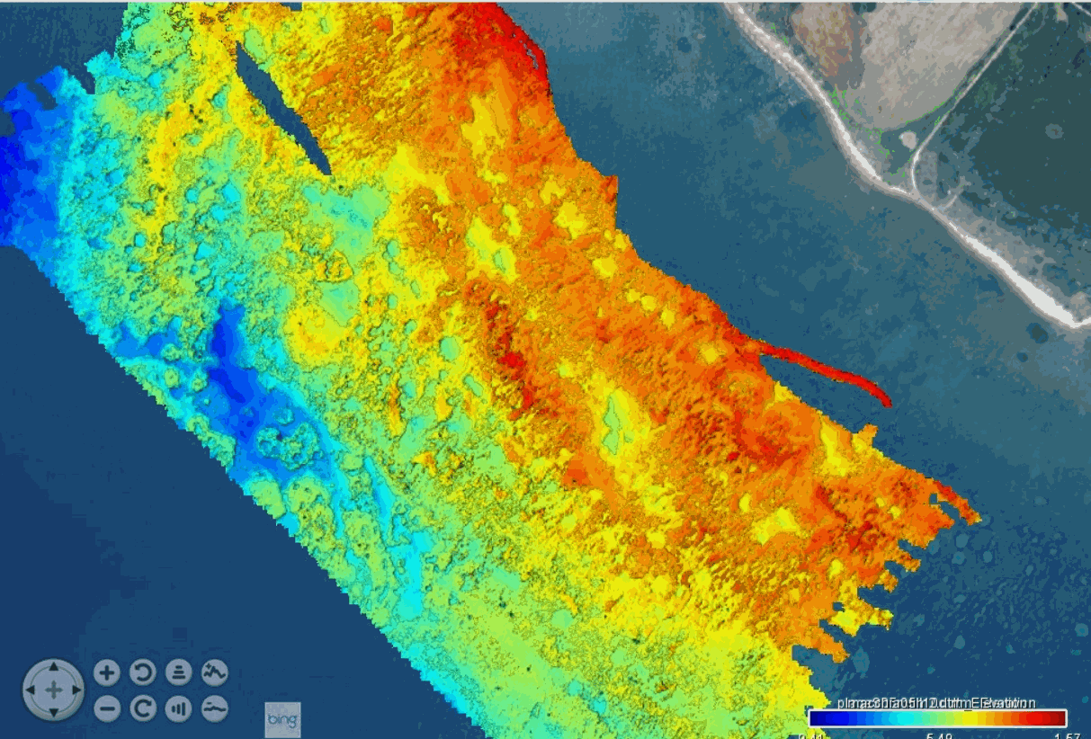
Swath bathymetry along a stretch of coast near the etruscan settlement of Pyrgi, Santa Severa, Italy
These bathymetric data were produced using the interferometric side-scan sonar onboard the Haliotis Research Vessel, Operated by Genavir, for the French Oceanographic Fleet, in September 2022, during the oceanographic campaign HISOPE (l'Haliotis pour l’Imagerie Sismique d’Orbetello et Pyrgi Etrusques).
The investigated area is located in front of the prominent archeological site of Pyrgi, the etruscan harbor of Cerveteri. At the site, next to the sea, is found a series of etruscan temples, surrounded by an etruscan city largely destroyed by coastal erosion. A roman castrum dating back to the 3rd century BCE covers part of the site and is also partly eroded by the sea. Above the castrum is built a fortified medieval village as well as a large renaissance castle (Santa Severa), built over a submerged lava dome (the Massicciata reef). In 2019, foundations of an etruscan monument were discovered 150 m offhshore, over a larger reef located south of the archeological site (the Secche di Macchiatonda). The goal of this campaign was to map the seafloor along this stretch of eroded coastline, in order to determine the location of the coastline in Etruscan time, such as to better understand the geography of the site when the harbor was settled. One of the main questions is why this specific site was chosen to develop a port, despite its exposure to waves.
Acquisition took place under stormy conditions, such that only 1.5 day of acquisition was possible over the 7 days planned. Geoswath mapping was conducted under heavy swell conditions along the sandy coast, north of of the castle of Santa Severa, then in front of the sandy coast, south of the castle, and finally over the extensive Secche di Macchiatonda reef in the south.
Data were acquired by eng. Quentin Layahe, Genavir, onboard the Haliotis, piloted by Serge Garcia, and post-processed using the software Globe, developed by the IFREMER, by Dr.Gilles Brocard (Archéorient, University of Lyon 2, France) and Alessandro Conforti, research engineer at the CNR (Italian national center for research) at Orosi, Sardinia.
|
|
Citation proposal
Brocard Gilles (Archéorient, Maison de l'Orient et de la Méditerranée, University of Lyon 2, France) - Comforti Alessandro (Centro Nazionale della Riserca, Oristano, Sardinia, Italy) (2022) . Swath bathymetry along a stretch of coast near the etruscan settlement of Pyrgi, Santa Severa, Italy. https://services.mspdata.eu:/geonetwork/srv/api/records/seanoe:95885 |
Simple
- Date ( Publication )
- 2022-10
- Date ( Revision )
- 2023-07-24
- Other citation details
-
Brocard Gilles, Comforti Alessandro (2022). Swath bathymetry along a stretch of coast near the etruscan settlement of Pyrgi, Santa Severa, Italy. SEANOE. https://doi.org/10.17882/9588 5
Author
Publisher
- Keywords ( Theme )
-
-
coastal bathymetry
,geoswath
,eroded coastline
,archeology
,geomorphology
,etruria
,etruscan
,Pyrgi
,Santa Severa
,Santa Marinella
,Marine geology
-
- ODATIS aggregation parameters and Essential Variable names ( Theme )
-
- Bathymetry
- SeaDataNet Parameter Disciplines ( parameter )
-
- Marine geology
- Type de jeux de donnée ODATIS ( Theme )
-
- /Observational data/in-situ
- Use constraints
- Other restrictions
- Other constraints
- Date ( Publication )
- 2022
Publisher
Author
Author
- Association Type
- Cross reference
- Initiative Type
- dataset
- Association Type
- Cross reference
- Initiative Type
- Platform
- Metadata language
- English
- Topic category
-
- Oceans
))
- Distribution format
-
-
IMAGE
()
-
- OnLine resource
-
Processed data
Bathymetry along the coast of Pyrgi at 50 cm resolution, projection system WGS 84, UTM zone 32 N (format GeoTIFF) - 177 MB
- OnLine resource
-
Processed data
10 cm -resolution bathymetry of the Secche di Macchiatonda reef, projection system WGS 84, UTM zone 32 N (format GeoTIFF) - 2 GB
- OnLine resource
- DOI of the product
- OnLine resource
- Seanoe
- Hierarchy level
- Dataset
- Statement
-
Interferometric side-scan sonar of the Haliotis
A side-scan sonar builds detailed acoustic images of the seafloor.
The interferometric side-scan sonar comprises a bathymetric function. To make a side-scan sonar interferometric, the height of an echo on the bottom has to be linked to the angle of arrival by accurately measuring the phase difference of the arrival times on the various arrays stacked on either side. By using the true bearing and the slant range (obtained by other means), the position of the sounding points can be established in three dimensions.
The main advantage of an interferometric side-scan sonar over a multibeam sounder is its greater swath width in shallow water. Bathymetric measurements are, however, less accurate than those produced by a multibeam echo sounder and suffer from excessive noise at the end of the range.
The launch Haliotis is equipped with a Geoswath interferometric sonar fixed rigidly to the hull. The device functions at a frequency of 250 kHz and provides the following measurements:
Data were post-processed using "Globe (GLobal Oceanographic Bathymetry Explorer) Software." (2019) developed by Cyrille Poncelet, Gael Billant, and Marie-Paule Corre
Metadata
- File identifier
- seanoe:95885 XML
- Metadata language
- English
- Character set
- UTF8
- Hierarchy level
- Dataset
- Date stamp
- 2023-07-24
- Metadata standard name
-
ISO 19115:2003/19139
- Metadata standard version
-
1.0
Overviews
Provided by
