Metadata catalogue
MAUPITI HOE - wave friction
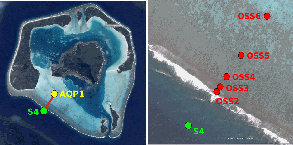
Maupiti ("the Stuck Twins'') is a diamond-shaped island located in the western part of the Society archipelago in French Polynesia. The present study focuses on the data recovered over a single cross-barrier transect located in the south-west barrier during the MAUPITI HOE field campaign, from 5 to 18 July 2018. The studied area is representative of the reef structure observed along the 4km-long southwestern barrier reef, showing an alongshore-uniform structure exposed to swell approaching with weak incident angles, a healthy reef colony. In the cross-barrier direction, the reef displays a clear partitioning of bottom roughness that ranges from low-crested compact structures at the reef crest to higher and sparser coral bommies on the backreef. The experimental setup was specifically designed to analyse and differentiate the dynamics over three roughness-contrasting sections found over the barrier reef.
|
|
Citation proposal
Quentin Céline () - Sous Damien (Université de Toulon, Aix Marseille Univ, CNRS, IRD, MIO, Toulon, France) (2022) . MAUPITI HOE - wave friction. https://services.mspdata.eu:/geonetwork/srv/api/records/seanoe:91337 |
Simple
- Date ( Publication )
- 2022-12-05
- Date ( Revision )
- 2023-02-16
- Other citation details
-
Sous Damien (2022). MAUPITI HOE - wave friction. SEANOE. https://doi.org/10.17882/91337
- Credit
-
The complete experimental campaign MAUPITI HOE has been funded and supported by the GLADYS nearshore research group
Custodian
Publisher
- Keywords ( Theme )
-
-
Earth Science > Oceans
,Earth Science > Oceans > Bathymetry/Seafloor Topography > Bathymetry > coastal bathymetry
,Earth Science > Oceans > Coastal processes
,Earth Science > Oceans > Coastal processes > Sea Surface Height
,Earth Science > Oceans > Hydrography
,Instruments > In Situ/Laboratory Instruments > Gauges > Water level gauges
,Locations > Ocean > Pacific Ocean > South Pacific Ocean > French polynesia
,morphodynamic
,wave friction
,Physical oceanography
-
- ODATIS aggregation parameters and Essential Variable names ( Theme )
-
- Bathymetry , Shoreline , Waves
- SeaDataNet Parameter Disciplines ( parameter )
-
- Physical oceanography
- Type de jeux de donnée ODATIS ( Theme )
-
- /Observational data/in-situ
- Use constraints
- Other restrictions
- Other constraints
-
The data may be used and redistributed for free but is not intended for legal use, since it may contain inaccuracies. Neither the data Contributor, MIO, OSU Pytheas, CNRS, nor the French Government, nor any of their employees or contractors, makes any warranty, express or implied, including warranties of merchantability and fitness for a particular purpose, or assumes any legal liability for the accuracy, completeness, or usefulness, of this information.
- Date ( Publication )
- 2023
Publisher
Author
Author
Author
Author
Author
- Association Type
- Cross reference
- Initiative Type
- Study
- Date ( Publication )
- 2022
Publisher
Author
Author
Author
Author
- Association Type
- Cross reference
- Initiative Type
- Study
- Date ( Publication )
- 2020
Publisher
Author
Author
Author
Author
Author
Author
Author
Author
- Association Type
- Cross reference
- Initiative Type
- Study
- Date ( Publication )
- 2021
Publisher
Author
Author
- Association Type
- Cross reference
- Initiative Type
- dataset
- Metadata language
- English
- Topic category
-
- Oceans
))
- Distribution format
-
-
NC, NETCDF
() -
TEXTE
()
-
- OnLine resource
-
Processed data
Instantaneous Sea Levels from 4 water level gauges around Maupiti Island (french polynesia) - 150 MB
- OnLine resource
-
Processed data
Bathymetric profile : Z bottom depth in meter along X axis in meter straight aline between 2 points (-16.471332°N, -152.278081°E and -16.463089°N, -152.272216°W) - 77 KB
- OnLine resource
- DOI of the product
- OnLine resource
- Seanoe
- Hierarchy level
- Dataset
- Statement
-
Four pressure sensors (OSS3, OSS4, OSS5, OSS6) have been deployed across the reef flat/ backreef, outside the surf zone. The bottom pressure is measured continuously at 10 Hz, and are converted into free surface elevation assuming hydrostaticity.
An electrocurrent meter S4 provides the wave forcing while AQP1 is a velocity profiler providing the transports.
The bed profile is obtained from the combination of (I) boat survey in the deeper part and (ii) high resolution GNSS RTK topography by feet.
S4 position : -16.47109°N; -152.2782°E OSS3 position: -16.46968°N; -152.27698°E OSS4 position : -16.46931°N; -152.27676°E OSS5 position : -16.46851°N;-152.27614°E OSS6 position: -16.46706°N; -152.27504°E AQP1 position: -16.46318°N ; -152.27348°E
Metadata
- File identifier
- seanoe:91337 XML
- Metadata language
- English
- Character set
- UTF8
- Hierarchy level
- Dataset
- Date stamp
- 2023-02-16
- Metadata standard name
-
ISO 19115:2003/19139
- Metadata standard version
-
1.0