Metadata catalogue
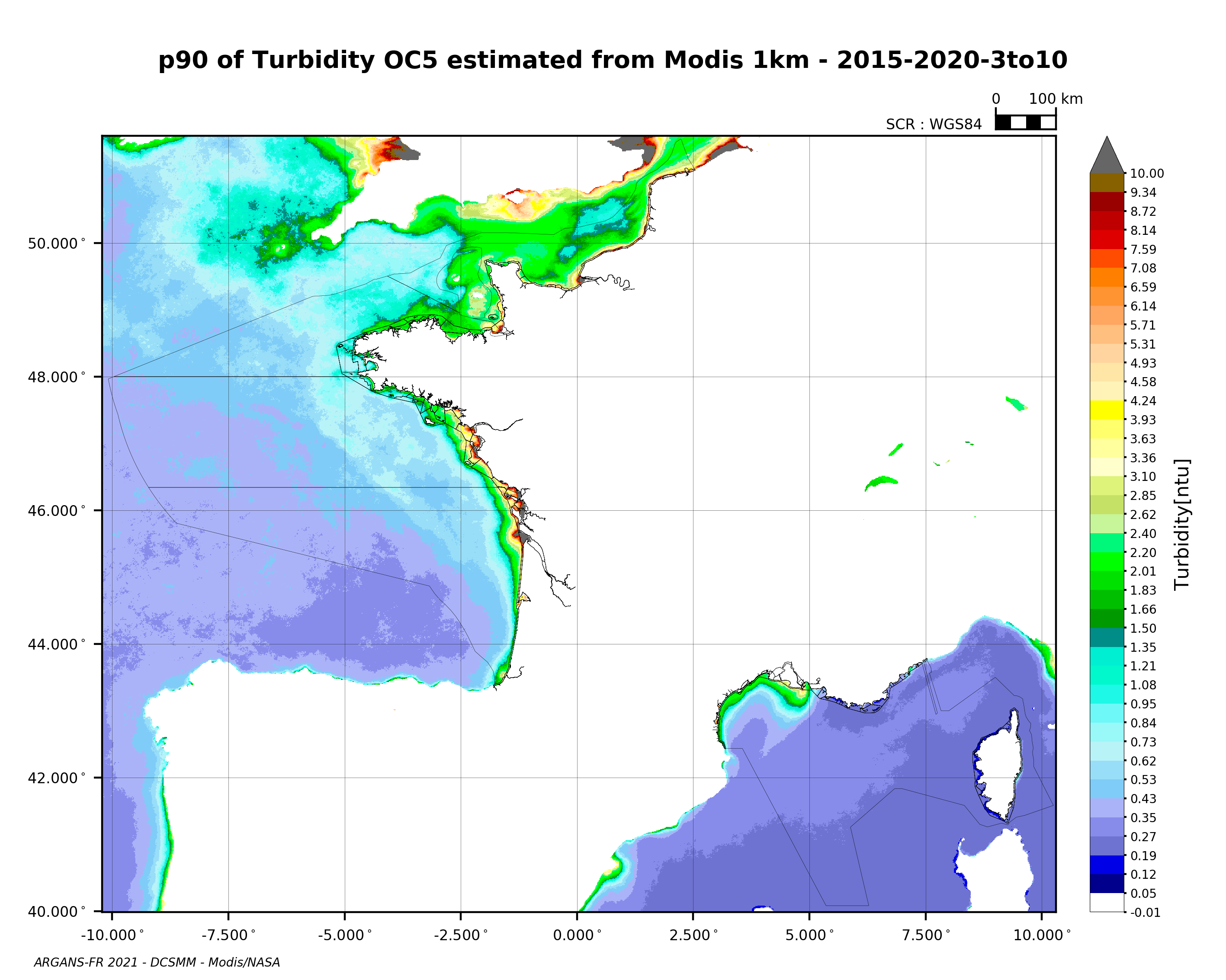
Percentile 90 de la turbidité (MODIS) 2015-2020
Percentile 90 de la turbidité calculé sur la période productive au sens DCE (mars-octobre) 2015-2020, à partir des images satellite MODIS traitées par l'algorithme OC5 IFREMER/ARGANS (Gohin et al 2002, Gohin 2011).
|
|
Citation proposal
Bryère Philippe Bryère Philippe (ARGANS ARGANS ) (2021) . Percentile 90 de la turbidité (MODIS) 2015-2020. Ifremer Ifremer https://services.mspdata.eu:/geonetwork/srv/api/records/f83d2f7c-8dc0-4492-ae37-f77f64bfb672 |
Simple
- Alternate title
-
P90
- Date ( Publication )
- 2021-10-19T17:05:00
- Identifier
-
p90_modis_turbidity_2015-2020_3to10_dcsmm
- Unique resource identifier
- Presentation form
- Digital map
- Other citation details
-
MODIS/NASA capteur AQUA
- Purpose
- Credit
-
NASA, Argans
- Status
- Completed
Publisher
Centre Bretagne - ZI de la Pointe du Diable - CS 10070 - 29280 Plouzané
Brest
France
- Maintenance and update frequency
- As needed
- Thèmes Sextant Thèmes Sextant ( Theme )
-
-
/Imagerie/Imagerie satellitale
-
- GEMET - INSPIRE themes, version 1.0 GEMET - INSPIRE themes, version 1.0 ( Theme )
-
-
Caractéristiques géographiques océanographiques
-
- external.theme.gemet external.theme.gemet ( Theme )
-
-
chlorophylle
-
- Keywords ( Theme )
-
-
turbidité
,Satellite
-
- Type de jeux de donnée ODATIS Type de jeux de donnée ODATIS ( Theme )
-
-
/Télédétection
-
- Thématiques - SIMM Thématiques - SIMM ( Theme )
-
-
/Etat du Milieu/Biogéochimie
-
- Sous-regions marines Sous-regions marines ( Place )
-
-
/Métropole
-
- Cadre Réglementaire - SIMM Cadre Réglementaire - SIMM ( Theme )
-
-
Directive Cadre Stratégie pour le Milieu Marin (DCSMM)
-
- DCSMM : Descripteurs DCSMM : Descripteurs ( Theme )
-
-
D1: Biodiversité - Habitats pélagiques
,D1: Biodiversité - Céphalopodes
,D1: Biodiversité - Poissons
,D4: Réseaux trophiques
,D5: Eutrophisation
,D6: Intégrité des fonds marins
-
- Use limitation
- CC-BY-NC-ND (Creative Commons - Attribution, Pas d’utilisation commerciale, Pas de modification) CC-BY-NC-ND (Creative Commons - Attribution, Pas d’utilisation commerciale, Pas de modification) CC-BY-NC-ND (Creative Commons - Attribution, No commercial usage, No modification)
- Access constraints
- Other restrictions
- Use constraints
- Intellectual property rights
- Other constraints
-
Ces données ne peuvent être utilisées que dans le cadre de la DCSMM et pour des projets de recherche mais en aucun cas pour dans un cadre commercial.
- Spatial representation type
- Grid
- Distance
- 1200 m
- Metadata language
- French
- Metadata language
- English
- Character set
- UTF8
- Topic category
-
- Oceans
- Environment description
-
Microsoft Windows XP ; ESRI ArcGIS 9.x
- Geographic identifier
-
Plateau Ouest-Européen
))
- Supplemental Information
-
Gohin, F., Druon, J. N., and Lampert, L.: A five channel chlorophyll concentration algorithm applied to SeaWiFS data processed by Seadas in coastal waters, International Journal of Remote Sensing, 23, 1639-1661, 10.1080/01431160110071879, 2002.
- Reference system identifier
-
WGS 84 (EPSG:4326)
- Number of dimensions
- 2
- Dimension name
- Column
- Dimension size
- 1367
- Resolution
- 0.015 degree
- Dimension name
- Row
- Dimension size
- 1160
- Resolution
- 0.01 degree
- Cell geometry
- Area
- Transformation parameter availability
- false
Point of contact
- Protocol
-
COPYFILE
- Name
-
p90_modis_turbidity_2015-2020_3to10_dcsmm
- Description
-
Percentile90 - Turbidité (Geotiff)
- Units of distribution
- Protocol
-
COPYFILE
- Name
-
mean_modis_turbidity_2015-2020_3to10_dcsmm
- Description
-
Moyenne - Turbidité (Geotiff)
- Protocol
-
COPYFILE
- Name
-
stdev_modis_turbidity_2015-2020_3to10_dcsmm
- Description
-
Ecart-type - Turbidité (Geotiff)
- Protocol
-
COPYFILE
- Name
-
nbpts_modis_turbidity_2015-2020_3to10_dcsmm
- Description
-
Nombre de pixels utilisés en chaque point - Turbidité (Geotiff)
- Hierarchy level
- Dataset
Conformance result
- Date ( Publication )
- 2007-03-14
- Explanation
-
Non évalué
- Pass
- false
- Statement
-
Capteur : satellite MODIS-Aqua (NASA)
Période : 2015-2020
Algorithmes : OC5 IFREMER/ARGANS (Gohin et al 2002, Gohin 2011).
Produit élaboré : P90 calculé sur la période 2015-2020 à partir des données journalières + Moyenne, écart type et nombre de pixels utilisés pour le calcul en chaque point de la carte.
Metadata
- File identifier
- f83d2f7c-8dc0-4492-ae37-f77f64bfb672 XML
- Metadata language
- French
- Character set
- UTF8
- Hierarchy level
- Dataset
- Date stamp
- 2021-10-19T11:23:41
- Metadata standard name
-
ISO 19115:2003/19139 - SEXTANT
- Metadata standard version
-
1.0