Metadata catalogue
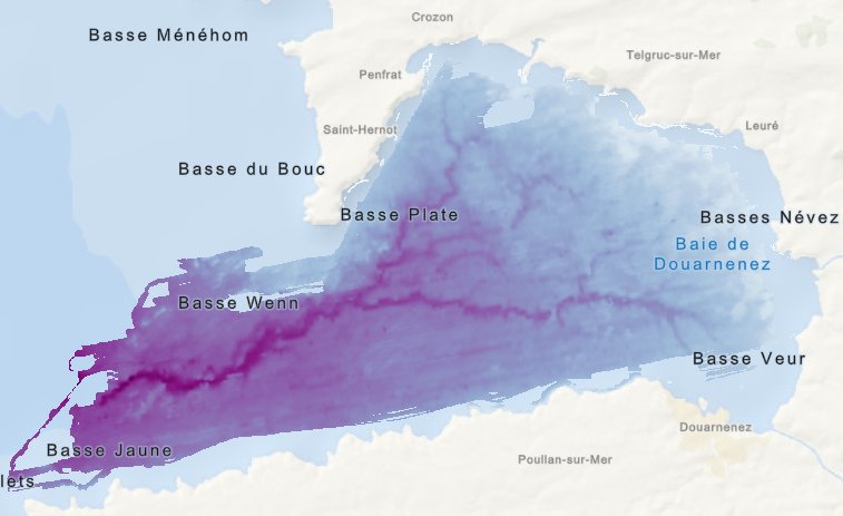
Morpho-bathymétrie du substratum rocheux de la baie de Douarnenez (G. Jouet, 2005), raster
Jeu de données raster correspondant à la "Carte morpho-bathymétrie du substratum rocheux de la baie de Douarnenez", éditée en 2005 dans l'atlas thématique de l'environnement marin de la baie de Douarnenez.
Campagne océanographique à l'origine du jeu de données :
- AUGRIS Claude, NORMAND Alain (2000) CANADOU cruise, RV Thalia, https://doi.org/10.17600/70020
Références bibliographiques :
- AUGRIS C., MENESGUEN A., HAMON D., BLANCHET A., LE ROY P., ROLET J., JOUET G., VERON G., DELANNOY H., DROGOU M., BERNARD C., MAILLARD X. (2005), Atlas thématique de l'environnement marin de la baie de Douarnenez (Finistère). 10 cartes, échelle 1/25 000 et un livret d'accompagnement, 135 p. Ed. Ifremer - Ville de Douarnenez.
- Jouet, G., Augris, C., Hallegouët, B., Le Roy, P., Rolet, J., 2003. La vallée d'Ys : un paléoréseau hydrographique immergé en Baie de Douarnenez (Finistère, France). Comptes Rendus Geoscience 335, 487-494.
|
|
Citation proposal
JOUET Gwenaël (Ifremer) - MAZE Jean-Pierre (Ifremer) (2023) . Morpho-bathymétrie du substratum rocheux de la baie de Douarnenez (G. Jouet, 2005), raster. Ifremer https://services.mspdata.eu:/geonetwork/srv/api/records/d824d0ac-1a4d-41a0-91a0-04c0ae12055e |
Simple
- Date ( Creation )
- 2005-01-01
- Date ( Publication )
- 2023-04-17
- Identifier
-
FR-330715-368-00032-Substratum_BaieDouarnenez_Jouet_2005
- Identifier
-
DOI:10.12770/d824d0ac-1a4d-41a0-91a0-04c0ae12055e
- Presentation form
- Digital map
- Credit
-
Ifremer
- Status
- completed Completed
Point of contact
Publisher
Author
- Maintenance and update frequency
- As needed
- Keywords ( Place )
-
- GEMET - INSPIRE themes, version 1.0 ( Theme )
-
- Géologie
- GEMET ( Theme )
-
-
Geophysics
-
- Thèmes Sextant ( Theme )
-
- /Cartes scannées/Ifremer/Sédimentologie
- Ocean Hackathon - Ville et défi ( Place )
-
- Use limitation
-
Accès aux données à la demande gmcarto@ifremer.fr
- Use limitation
- Use limitation
- Access constraints
- Other restrictions
- Use constraints
- License
- Other constraints
-
Pas de restriction d'accès public
- Other constraints
-
Citation : JOUET G. - Substratum rocheux de la baie de Douarnenez (Finistère). Ifremer
- Association Type
- Cross reference
- Initiative Type
- Platform
- Association Type
- Cross reference
- Initiative Type
- Study
- Spatial representation type
- grid Grid
- Denominator
- 25000
- Distance
- 41.654 meter
- Metadata language
- French
- Character set
- utf8 UTF8
- Topic category
-
- Oceans
- Environment description
-
Microsoft Windows 7 Version 6.1 (Build 7601) Service Pack 1; Esri ArcGIS 10.3.0.4322
))
- Reference system identifier
-
EPSG
/WGS 84 (EPSG:4326)
/8.6
- Number of dimensions
- 2
- Dimension name
- Column
- Dimension size
- 868
- Resolution
- 41.654 m
- Dimension name
- Row
- Dimension size
- 510
- Resolution
- 41.654 m
- Cell geometry
- Area
- Transformation parameter availability
- true
- Checkpoint Availability
- false
Center point
- Point in Pixel
-
- centre
- Distribution format
-
-
GeoTIFF
()
-
- OnLine resource
-
Substratum_BaieDouarnenez_Jouet_2005
Substratum rocheux de la baie de Douarnenez
- Hierarchy level
- Dataset
Domain consistency
Conformance result
- Date ( Publication )
- 2013-12-10
- Identifier
-
D2.8.II.4_v3.0
- Explanation
-
Non évalué
- Pass
- false
- Statement
Metadata
- File identifier
- d824d0ac-1a4d-41a0-91a0-04c0ae12055e XML
- Metadata language
- French
- Character set
- UTF8
- Hierarchy level
- Dataset
- Hierarchy level name
-
dataset
- Date stamp
- 2025-06-19T08:20:24.182169Z
- Metadata standard name
-
ISO 19115-3 - SEXTANT
- Metadata standard version
-
1.0