 Metadata catalogue
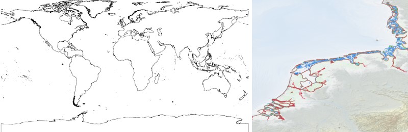
EMODnet Bathymetry - World Coastline version 2024
The EMODnet Bathymetry World Coastline is available as a WFS service from EMODnet Bathymetry. The service URL is: https://ows.emodnet-bathymetry.eu/wfs . The layer contains vector lines derived from land polygons available from OpenStreetMap. The original source url is https://osmdata.openstreetmap.de/ . Parts of these polygons have been modified for use in EMODnet Bathymetry.
In addition to the OSM EMODnet default coastline, three sub-layers are available as part of the EMODnet world coastline service. These sub-layers contain the best-estimate coastlines for Europe determined by Dutch research institute Deltares from satellite data (typically Sentinel-2 and Landsat-8) and in combination with the Global Tide Surge Model (GTSM) processed into digital coastlines for the European seas at LAT (Lowest Astronomical Tide), MSL (Mean-Sea-Level), and MHW (Mean-High-Water). The level of detail is bound to the resolution of the satellite sensor (e.g. 10m for Sentinel-2). The latest 2024 version covers the entire coastline of Europe and now also part of the Caribbean.
A detailed paper is available describing the methodology used to determine the three versions of the satellite derived coastline:
|
|
Citation proposal
Deltares (2024) . EMODnet Bathymetry - World Coastline version 2024. EMODnet Bathymetry consortium https://services.mspdata.eu:/geonetwork/srv/api/records/be8828f0-9390-4e5d-8f30-6831463d4d4b |
Simple
- Date ( Publication )
- 2024-01-31
- Identifier
-
EMODnet_Bathymetry_coastliines
- Credit
Publisher
Author
- Thèmes Sextant ( Theme )
-
-
/Physical Environment/Physiographic Limits/Shoreline
-
- GEMET - INSPIRE themes, version 1.0 ( Theme )
-
-
Land cover
-
- Ocean Hackathon - City and challenge ( Place )
-
-
/Boulogne-sur-Mer
,/Brest
,/Nord de la Réunion
,/Cape Town
,/La Rochelle
,/Nouméa
,/Bournemouth
,/International and global data portals
,/Concepción
,/Peniche
,/Rimouski
,/Toulon
,/Cherbourg
,/Kuala Lumpur
,/Plymouth
-
- Use limitation
- Access constraints
- Creative Commons Attribution 4.0 International
- Use constraints
- Other restrictions
- Other constraints
-
DO NOT USE FOR NAVIGATION
- Spatial representation type
- vector Vector
- Metadata language
- English
- Character set
- utf8 UTF8
- Topic category
-
- Oceans
- Boundaries
))
- Distribution format
-
- ()
- OnLine resource
- EMODnet Bathymetry WMTS service
- OnLine resource
- EMODnet viewer
- OnLine resource
-
EMODnet_Bathymetry_2024_coastlines
Coastline layer 2024 (zip)
- OnLine resource
-
coastlines
Coastlines
- OnLine resource
- Digital Object Identifier (DOI)
- Hierarchy level
- Dataset
Domain consistency
Conformance result
- Date ( Publication )
- 2010-12-08
- Explanation
-
See the referenced specification
- Statement
-
The EMODnet World Coastline service includes:
• Satellite Derived Coastlines for European waters at different tidal elevations
• World Coastline, derived from OpenStreetMap (OSM)
Existing methods for surface water detection from multispectral satellite data use the fact that water significantly absorbs most radiation at near-infrared wavelengths and beyond. This fact makes it easy to detect clear water employing spectral indices, such as the Normalized Difference Water Index (NDWI). In EMODnet-Bathymetry, a NDWI algorithm is used to derive coastlines for the European waters and part of the Caribbean waters from satellite imagery. This in combination with a tidal model allows, to retrieved coastlines at different vertical datum (Mean-Sea-Level (MSL), Mean-High-Water (MHW), and Lowest Astronomical Tide (LAT)). Huge volumes of satellite data have been processed in parallel using a mixture of top-of-atmosphere reflectance satellite images from NASA/USGS Landsat 8 and ESA Sentinel-2 satellite missions, acquired during 2013-2020. For the correction for sea level variation use has been made of the Global Tide and Surge Model (GTSMv4.1) from Deltares, which provides instantaneous water level and tide levels with global coverage. More detailed information can be found in:
The Satellite Derived Coastlines are available for download as shape files and included in the Coastlines map layer on the EMODnet Central Map Viewer, and included in the EMODnet Bathymetry OGC WMS service.
OpenStreetMap (OSM) is a collaborative project to create a free editable map of the world. The geodata underlying the map is considered the primary output of the project. The creation and growth of OSM has been motivated by restrictions on use or availability of map data across much of the world, and the advent of inexpensive portable satellite navigation devices. OSM is considered a prominent example of volunteered geographic information.
The land polygons describe polygons for all land areas in the world, ie. continents and islands. Optionally, large polygons are split into smaller overlapping chunks that are easier and faster to work with.
The data has been derived from OpenStreetMap ways tagged with natural=coastline. Ways are assembled into polygons and then split. Some errors in the OSM data are repaired in the process. Where polygons have been split they overlap slightly to help avoiding rendering artefacts at the seams.
The OSM derived world coastline is included in the Coastlines map layer on the EMODnet Central Map Viewer, and included in the EMODnet Bathymetry OGC WFS service.
Metadata
- File identifier
- be8828f0-9390-4e5d-8f30-6831463d4d4b XML
- Metadata language
- English
- Character set
- UTF8
- Hierarchy level
- Dataset
- Date stamp
- 2025-05-15T23:57:31.59669Z
- Metadata standard name
-
ISO 19115-3 - SEXTANT
- Metadata standard version
-
1.0
Point of contact
Overviews


Provided by
