Metadata catalogue
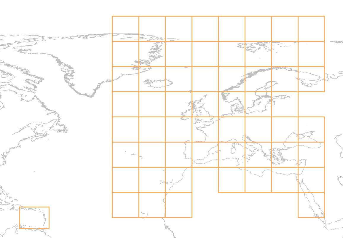
Download service for EMODnet Bathymetry Product tiles
The download service for EMODnet Bathymetry Product tiles is a WMS service showing the graphical extent for all downloadable tiles of the EMODnet Bathymetry DTM. The service allows a user the query an individual tile. The GetFeatureInfo response of this action provides a list of the available data formats for the inquired tile.
|
|
Citation proposal
. Download service for EMODnet Bathymetry Product tiles. https://services.mspdata.eu:/geonetwork/srv/api/records/b79b28b4-182b-4f5d-9cdb-b23fd216cfee |
Simple
- Date ( Publication )
- Identifier
-
FR-330-715-368-00032-EMODnet-Bathy_Tile-Donwload
- Credit
Point of contact
- GEMET - INSPIRE themes, version 1.0 ( Theme )
-
- Thèmes Sextant ( Theme )
-
- Ocean Hackathon - City and challenge ( Place )
-
-
/Boulogne-sur-Mer
,/Bournemouth
,/Brest
,/Cherbourg
,/La Rochelle
,/Peniche
,/Plymouth
,/Toulon
-
- Use limitation
- Access constraints
- Creative Commons Attribution 4.0 International
- Use constraints
- Other restrictions
- Other constraints
-
DO NOT USE FOR NAVIGATION
- Spatial representation type
- grid Grid
- Metadata language
- English
- Character set
- utf8 UTF8
- Topic category
-
- Oceans
))
- Reference system identifier
-
EPSG
/WGS 84 (EPSG:4326)
/8.6
- Number of dimensions
- 0
- Cell geometry
- Area
- Transformation parameter availability
- false
- Distribution format
-
- ()
- OnLine resource
- EMODnet Bathymetry WMTS service
- OnLine resource
- EMODnet viewing service
- Hierarchy level
- Dataset
- Statement
-
The following formats are available for each of the tiles:
- EMO
- EMO without GEBCO data
The EMO format is a gridded delimited ASCII format and can be read as point data by all mainstream GIS. The format contains all subfields of the EMODnet Bathymetry DTM. The format is described here: https://emodnet.ec.europa.eu/sites/emodnet.ec.europa.eu/files/public/20171127_DTM_exchange_format_specification_v1.6.pdf
- esri ASCII grid relative to Lowest Astronomical Tide
- esri ASCII grid relative to Mean Sea Level
The esri ASCII grid is the most commonly used industry standard grid format. The files only contain the main depth field of the EMODnet Bathymetry DTM. The format is described here: https://en.wikipedia.org/wiki/Esri_grid
- 32 bit floating point GeoTiff
A geo referenced grid of the mean depth field of the EMODnet Bathymetry DTM with 1/16 arc minute resolution ( EMODnet Bathymetry resolution). The 32 bit floating point value represents the mean depth of the EMODnet Bathymetry DTM. More information can be found here:
https://en.wikipedia.org/wiki/GeoTIFF
- RGB GeoTiff
A geo referenced image representation of the mean depth field of the EMODnet Bathymetry DTM with 1/16 arc minute resolution ( EMODnet Bathymetry resolution). 24 bit full color 3 bands. It is based on a multi color (rainbow) color map. More information can be found here: https://en.wikipedia.org/wiki/GeoTIFF
- NetCDF
The NetCDF format (.nc) is self-describing, machine-independent data formats that support the creation, access, and sharing of array-oriented scientific data. For EMODnet Bathymetry the CF convention is used. As such the NetCDF tiles are readable by most mainstream GIS. The format contains all subfields of the EMODnet Bathymetry DTM described here:
The NetCDF tiles are optimized for use with the Globe software created by Ifremer. Details can be found here: https://doi.org/10.17882/70460
- ASCII xyz
Tiles in this format contain are gridded comma delimited ASCII files that can be read as point files in all mainstream GIS. The format only contains the mean depth of the EMODnet Bathymetry DTM
Metadata
- File identifier
- b79b28b4-182b-4f5d-9cdb-b23fd216cfee XML
- Metadata language
- English
- Character set
- UTF8
- Hierarchy level
- Dataset
- Date stamp
- 2025-05-15T23:52:20.308636Z
- Metadata standard name
-
ISO 19115-3 - SEXTANT
- Metadata standard version
-
1.0