Metadata catalogue
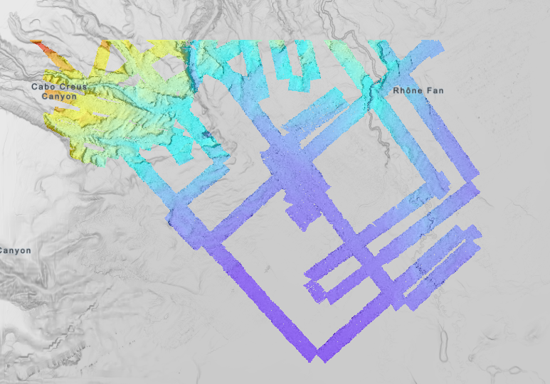
Bathymétrie - golfe du Lion (campagne AM-MED-1, mission AM-MED-1 LEG1, 2013) résolution 15 m
Bathymétrie du golfe du Lion, au pas de 15 mètres. Ce jeu de données est un Modèle Numérique de Terrain bathymétrique, issu de l'acquisition acoustique du sondeur multifaisceaux EM302 du N/O Le Suroît, lors du leg 1 de la campagne AM-MED-1.
Rapport de traitement : Saout Johan (2015). AM-MED1/ Leg1 : traitement des données SMF.
Description de la campagne : RABINEAU Marina, DROZ Laurence, ASLANIAN Daniel (2013) AM-MED-1 cruise, RV Le Suroît, https://doi.org/10.17600/180008 21
Description de la mission : RABINEAU Marina, DROZ Laurence, ASLANIAN Daniel (2013) AM-MED-1 LEG1 cruise, RV Le Suroît, https://doi.org/10.17600/13020050
|
|
Citation proposal
Ifremer Geo-Ocean (Ifremer) (2023) . Bathymétrie - golfe du Lion (campagne AM-MED-1, mission AM-MED-1 LEG1, 2013) résolution 15 m. Ifremer https://services.mspdata.eu:/geonetwork/srv/api/records/b3c1df6b-3bb6-48ee-8b01-6d28f06e40aa |
Simple
- Date ( Publication )
- 2023-03-08
- Date ( Revision )
- 2023-03-08
- Identifier
-
FR-330715-368-00032-AMMED1_Leg1_15m_BATHY
- Credit
-
IUEM / CNRS / Ifremer
- Status
- completed Completed
Author
Publisher
Point of contact
Point of contact
Point of contact
- Thèmes Sextant Thèmes Sextant ( Theme )
-
-
/Milieu physique/Bathymétrie
-
- GEMET - INSPIRE themes, version 1.0 GEMET - INSPIRE themes, version 1.0 ( Theme )
-
-
Altitude
-
- GEMET - Concepts, version 2.4 GEMET - Concepts, version 2.4 ( Theme )
-
-
géomorphologie
,fond marin
-
- Keywords ( Discipline )
-
-
Bathymétrie
-
- Use limitation
- CC-BY (Creative Commons - Attribution) CC-BY (Creative Commons - Attribution) CC-BY (Creative Commons - Attribution)
- Access constraints
- Other restrictions
- Use constraints
- License
- Other constraints
-
Pas de restriction d'accès public
- Use limitation
-
Ne pas utiliser pour la navigation
- Spatial representation type
- grid Grid
- Denominator
- 30000
- Distance
- 15 meter
- Metadata language
- French
- Character set
- utf8 UTF8
- Topic category
-
- Oceans
))
- Codespace
-
EPSG
- Version
-
7.4
Spatial representation info
- Number of dimensions
- 2
- Dimension name
- Column
- Dimension size
- 13763
- Dimension name
- Row
- Dimension size
- 6873
- Cell geometry
- Area
- Distribution format
-
-
GeoTIFF
(1.0
)
-
- OnLine resource
- AMMED1_Leg1_15m_BATHY
- Protocol
-
COPYFILE
- Name
-
AMMED1_Leg1_15m_BATHY
- Description
- Hierarchy level
- Dataset
Domain consistency
Conformance result
- Date ( Publication )
- 2010-12-08
- Explanation
-
See the referenced specification
- Statement
-
2015 : Traitement des données avec le logiciel Caraibes (développé par l'Ifremer) : découpe par profil, filtrage automatique et manuel, correction de biais statistiques appliqués au profil sur le plateau (pour corriger les défauts de célérité sur les profondeurs au-dessus de 200 m). Pas de correction appliquée aux données sur la pente.
2023 : Jeu de données créé par la fusion de deux fichiers jointifs pré-existants, avec Globe, logiciel développé par l'Ifremer (Reproject and update bouding box).
Metadata
- File identifier
- b3c1df6b-3bb6-48ee-8b01-6d28f06e40aa XML
- Metadata language
- French
- Character set
- UTF8
- Hierarchy level
- Dataset
- Date stamp
- 2025-11-28T17:25:37.956629Z
- Metadata standard name
-
ISO 19115-3 - SEXTANT ISO 19115-3 - SEXTANT
- Metadata standard version
-
1.0