 Metadata catalogue
Experimental altimetry products ocean (M)SLA, (M)ADT with finer resolution - Sea Surface Heights and Currents - delayed-time - (multimissions - levels 3-4)
Multimission altimeter products "Experimental" with a finer resolution in preparation to the SWOT Era with sea surface heights computed with respect to a twenty-year mean and Geostrophic velocities, resulting from specific processes, available in delayed time. Use: regional studies, ocean variability (mesoscale circulation,...),
|
|
Citation proposal
(2018) . Experimental altimetry products ocean (M)SLA, (M)ADT with finer resolution - Sea Surface Heights and Currents - delayed-time - (multimissions - levels 3-4). https://services.mspdata.eu:/geonetwork/srv/api/records/a4c9e94f-858f-4dfd-b7f1-9c42a19df1ab |
Simple
- Date ( Publication )
- 2018-06-01
- Date
- Unique resource identifier
- Credit
-
AVISO+
Point of contact
- Centre de données ODATIS Centre de données ODATIS ( Theme )
-
-
CDS-SAT-AVISO
-
- Variables ODATIS Variables ODATIS ( Theme )
-
-
/Physical Oceanography/Currents
,/Physical Oceanography/SSH (Sea surface height)
-
- Keywords
-
- Type de jeux de donnée ODATIS Type de jeux de donnée ODATIS ( Theme )
-
-
/in-situ observations/Networks
,/Processed data/Composite products
,/Remote sensing
-
- Thèmatiques ODATIS Thèmatiques ODATIS ( Theme )
-
-
Operational oceanography
,Added-value products
-
- Processing level Processing level ( processing-level )
-
-
Level 3
,Level 4
-
- Use limitation
- Licence ouverte Licence ouverte
- Access constraints
- License
- Use constraints
- License
- Other constraints
-
Conditions of use are described in the Licence : https://www.aviso.altimetry.fr/fileadmin/documents/data/License_Aviso.pdf ,
Users should keep in mind that these products are experimental products. Notably, they are not produced on an operational basis.
Citations : "Those products were processed by SSALTO/DUACS and distributed by AVISO+ ( https://www.aviso.altimetry.fr ) with support from CNES”
- Spatial representation type
- Grid
- Metadata language
- French
- Character set
- UTF8
- Topic category
-
- Oceans
))
- Geometric object type
- Complex
- Distribution format
-
-
()
-
()
- OnLine resource
- Accès authentifié aux données le long de la trace, 5 Hz
- OnLine resource
- Accès authentifié aux données avec Interpolation Dynamique
- OnLine resource
- Accès authentifié aux données combinées avec bouées dérivantes
- OnLine resource
- Plus d'information sur AVISO+
- OnLine resource
- Manuel utilisateur
- OnLine resource
- TDS fileserver combined SST
- OnLine resource
- TDS fileserver combined with drifters
- OnLine resource
- TDS fileserver data with dynamic interpolation
- OnLine resource
- TDS fileserver le long de la trace 5 Hz
- OnLine resource
-
DOI dataset along-track Sea Level Anomalies 5Hz
DOI dataset along-track Sea Level Anomalies 5Hz
- Hierarchy level
- Dataset
- Statement
-
Regional products are :
- along-track Sea Level Anomalies (SLA, level-3), for the North Atlantic, Agulhas current areas from Jason-3, Jason-2, Saral/AltiKa, Cryosat-2 and Sentinel-3A measurements and between 2014/12 and 2017/04, depends on the mission. This Level-3 along-track product is delivered with a 5Hz (i.e. nearly 1km) sampling.
- gridded Sea Level Heights dedicated to Arctic Ocean (EASE2 grid definition),
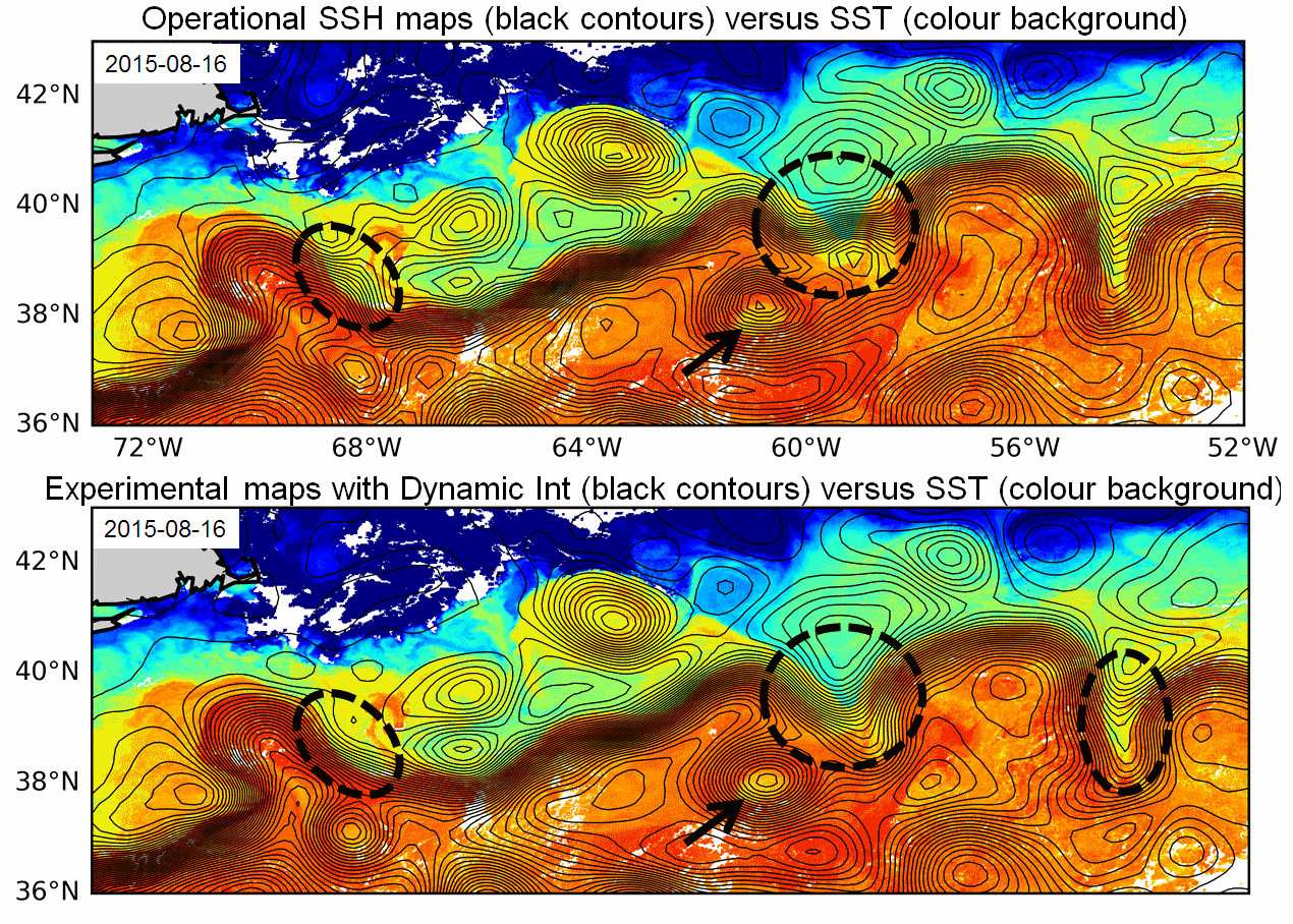
- gridded Sea Level Heights (MSLA, MADT, level-4) and geostrophic velocities computed with Dynamic Interpolation (1/8°x1/8° and 1/4°x1/4° on cartesian grid), over the Gulf Stream, Udinstev
- gridded Sea Level Anomalies (MSLA, level-4) and geostrophic velocities combining altimetry and drifters (1/4°x1/4° on a cartesian grid), over the Gulf of Mexico
The global product contents:
- the gridded optimally merged velocities (level-4) combining altimetry and SST (1/4°x1/4° on a cartesian grid). Note that this gridded products combining altimetry and SST have been calculated in the framework of three different projects: 1/ a Marie-Curie Fellowship cofunded by the European Union under the FP7-PEOPLE-Cofunding of Regional, National and International Programmes Grant Agreement 600407 and the RITMARE FLAG project (2014-2016), 2/ the ESA Globcurrent project (2014-2018), 3/ the DUACS-MR CNES project (2016-2018).
References for gridded computed with Dynamic Interpolation:
- Ubelmann, C., P. Klein, and L.-L. Fu, 2015: Dynamic interpolation of sea surface height and potential applications for future high-resolution altimetry mapping. J. Atmos. Oceanic Technol., 32, 177–184, doi:10.1175/JTECH-D-14-00152.1.
- Ubelmann C., B. Cornuelle and L-L Fu, 2016: Dynamic Mapping of Along-Track Ocean Altimetry: Method and Performance from Observing System Simulation Experiments. J. Atmos. Oceanic Technol., doi:10.1175/JTECH-D-15-0163.1
- Rogé, M., Morrow R., Ubelmann C. and G. Dibarboure, 2017 : Using a dynamical advection to reconstruct a part of the SSH evolution in the context of SWOT, application to the Mediterranean Sea. Ocean Dynamics, 67-8, 1047–1066
- Ubelmann C., M. Ballarotta, Y. Faugere, M. Rogé, R. Morrow, G. Dibarboure, Upcoming high-resolution regional products of Sea Level Anomaly from Dynamic Interpolation, OSTS 2017
References for gridded combining altimetry and drifters:
- Synergetic use of surface drifters and altimetry to increase resolution and accuracy of maps of sea level anomaly in the Gulf of Mexico, Mulet et al, OSTST 2017
References for gridded combining altimetry and SST:
- Rio, M-H, R. Santoleri, R. Bourdalle-Badie, A. Griffa, L. Piterbarg, G. Taburet, 2016: Improving the altimeter derived surface currents using high-resolution Sea Surface Temperature data: A feasibility study based on model outputs. Journal of Atmospheric and Oceanic Technology, Vol. 33, DOI: 10.1175/JTECH-D-16-0017.1.
Metadata
- File identifier
- a4c9e94f-858f-4dfd-b7f1-9c42a19df1ab XML
- Metadata language
- French
- Character set
- UTF8
- Hierarchy level
- Dataset
- Date stamp
- 2021-12-14T11:36:14
- Metadata standard name
-
ISO 19115:2003/19139 - SEXTANT
- Metadata standard version
-
1.0
Overviews


Provided by
