Metadata catalogue
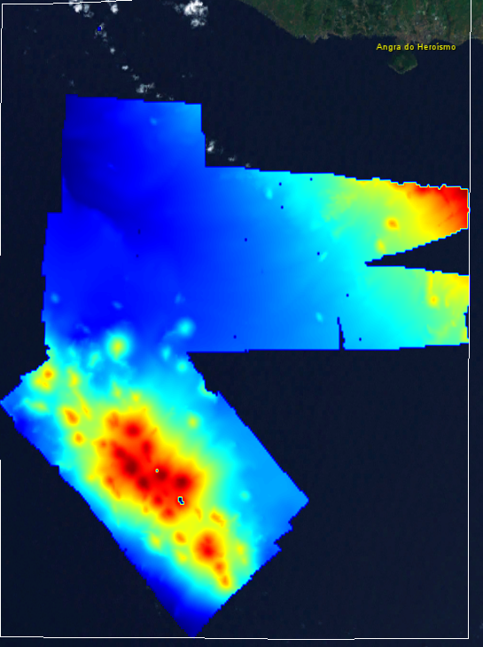
Bathymetry South of Ilha Terceira
Multibeam during Whale Prey Community Cruise 64PE456
|
|
Citation proposal
NIOZ Royal Netherlands Institute for Sea Research. Bathymetry South of Ilha Terceira. https://services.mspdata.eu:/geonetwork/srv/api/records/SDN_CPRD_630_MB64PE456 |
Simple
- Alternate title
-
KN172L08 SeaBeam 3012-P1 Bathymetry Grid
- Date ( Creation )
- 2020-12-08T00:00:00
- Date ( Revision )
- 2020-12-09T00:00:00
- Identifier
-
MB64PE456
Originator
Landsdiep 4
P.O. Box 59
Den Burg/Texel
1790 AB
Netherlands
Custodian
Landsdiep 4
P.O. Box 59
Den Burg/Texel
1790 AB
Netherlands
- Project name ( Theme )
-
-
EMODNet Bathymetry
-
- SeaDataNet device categories ( Theme )
-
-
multi-beam echosounders
,multi-beam echosounders
-
- SeaDataNet device categories ( Theme )
-
-
Differential Global Positioning System receivers
-
- Parameter Discovery Vocabulary (P02) ( parameter )
-
-
Bathymetry and Elevation
-
- GEMET - INSPIRE themes, version 1.0 ( Theme )
-
-
Hydrography
-
- Use limitation
-
Not for navigation
- Access constraints
- unrestricted
- Use constraints
- Copyright
- Other constraints
-
EMODnet Bathymetry consortium (2020), EMODnet Digital High Resolution DTM
- Use limitation
-
Not for navigation
- Denominator
- 200000
- Distance
- 0.015625 Arc minute
- Metadata language
- English
- Character set
- UTF8
- Topic category
-
- Oceans
))
- Unique resource identifier
- Description
-
Map projection parameters, values and units :
Axes units :
UPPER LEFT X=29.3054583250
UPPER LEFT Y=44.6262830219
LOWER RIGHT X=40.7816282263
LOWER RIGHT Y=41.2281769950
WEST LONGITUDE=29° 18' 19.6500" E
NORTH LATITUDE=44° 37' 34.6189" N
EAST LONGITUDE=40° 46' 53.8616" E
SOUTH LATITUDE=41° 13' 41.4372" N
PROJ_DESC=Geographic (Latitude/Longitude) / WGS84 / arc degrees
PROJ_DATUM=WGS84
PROJ_UNITS=arc degrees
EPSG_CODE=4326
COVERED AREA=353215 sq km
- Geographic identifier
-
EPSG
/WGS84 / Geographic coordinate system
/7.4
- Reference system identifier
-
EPSG
/WGS 84 (EPSG:4326)
/7.4
- Number of dimensions
- 3
- Dimension name
- Column
- Dimension size
- 1088
- Dimension name
- Row
- Dimension size
- 1152
- Dimension name
- Time
- Dimension size
- 1
- Cell geometry
- Point
- Transformation parameter availability
- false
- Checkpoint Availability
- false
- Point in Pixel
-
- Upper left
- Distribution format
-
- ()
Distributor
Landsdiep 4
P.O. Box 59
Den Burg/Texel
1790 AB
Netherlands
- OnLine resource
- EMODnet viewer
- Hierarchy level
- Dataset
Vertical extent
- Minimum value
- 269
- Maximum value
- 1510
Vertical CS
Vertical datum
- Statement
-
no information
- Hierarchy level
- Feature
- Dataset
-
accuracy
Gridded data positional accuracy
- Name of measure
-
horizontal accuracy
- Measure identification
-
horizontal accuracy of coordinate
- Measure description
- Evaluation method description
Quantitative result
- Value type
- horizontal accuracy
Quantitative attribute accuracy
- Name of measure
-
depth
- Measure identification
-
depth accuracy
- Measure description
- Evaluation method description
Quantitative result
- Value
- not defined
Conformance result
- Date
- Explanation
- Hierarchy level
- Software
- Description
-
MB-System
- Other
-
software
- Hierarchy level
- Property type
- Description
-
parameters of data processing
- Attributes
- Statement
-
EMODnet processing methodology using Globe software
- Description
-
CDI 630:MB64PE456
- Hierarchy level
- Dataset
Absolute external positional accuracy
- Name of measure
-
emodnet-bathymetry.QI.Horizontal
- Value
- 3 - < 20 m
Absolute external positional accuracy
- Name of measure
-
emodnet-bathymetry.QI.Vertical
- Value
- 4 - MBES High frequency (higher that 100kHz) (1+0.5%d)
Domain consistency
- Name of measure
-
emodnet-bathymetry.QI.Purpose
- Value
- 2 - Bathymetric/morphologic survey
Metadata
- File identifier
- SDN_CPRD_630_MB64PE456 XML
- Metadata language
- English
- Character set
- UTF8
- Hierarchy level name
-
Composite Product Record
- Date stamp
- 2020-12-09T14:02:29
- Metadata standard name
-
ISO 19115:2003/19139 - EMODNET - BATHYMETRY
- Metadata standard version
-
1.0
Author
Landsdiep 4
P.O. Box 59
Den Burg/Texel
1790 AB
Netherlands