 Metadata catalogue
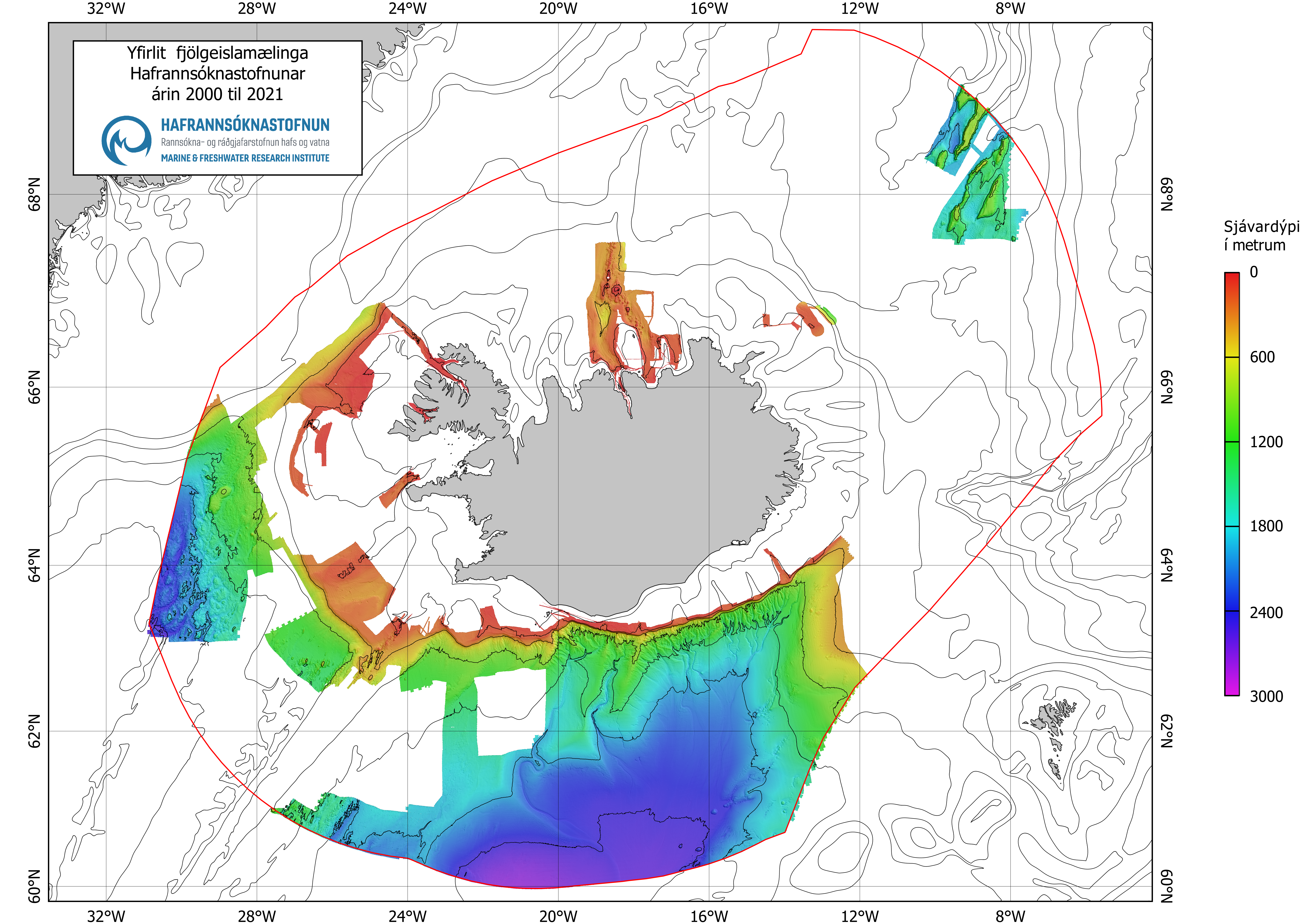
MFRI 2000-2019 Bathymetric Dataset
Seabed mapping is one of the Marine and Freshwater Research Institute´s projects which started with the launching of the research vessel, Arni Fridriksson RE 200, in the year 2000. The vessel is equipped with a multibeam echo sounder which enables a detailed mapping of the seabed. Until spring 2017 the multibeam echo sounder was of the type Kongsberg EM 300 (30 kHz, 135 beams, 2°x2°) but was then updated to Kongsberg EM 302 (30 kHz, 432 beams, 1°x2°, water column data). From the year 2017 the seabed mapping project is one of MFRI´s major initiatives for the next 12 years. The main emphasis is to gain information within the economic zone which is useful for multifaceted purpose and is a prerequisite for scientific approach for sustainable utilization, protection and research of resources in the ocean.
|
|
Citation proposal
Marine and Freshwater Research Institute. MFRI 2000-2019 Bathymetric Dataset. https://services.mspdata.eu:/geonetwork/srv/api/records/SDN_CPRD_4766_MFRI_2000-2019 |
Simple
- Alternate title
- Date ( Creation )
- 2022-08-23
- Date ( Revision )
- 2022-08-23
- Identifier
-
MFRI_2000-2019
Originator
Custodian
- Website
- web site
Point of contact
- Project name ( Theme )
-
- SeaDataNet device categories ( Theme )
-
-
multi-beam echosounders
-
- ( Stratum )
-
- Parameter Discovery Vocabulary (P02) ( parameter )
-
-
Bathymetry and Elevation
-
- GEMET - INSPIRE themes, version 1.0 ( Theme )
-
-
Hydrography
-
- SeaDataNet depth measurement reference planes ( Theme )
-
- Use limitation
-
Not suitable for navigation
- Access constraints
- unrestricted
- Use constraints
- Copyright
- Other constraints
-
Any use of maps or data from this website shall be cited to its origin.
- Use limitation
-
Not for navigation
- Spatial representation type
- Grid
- Denominator
- 100000
- Metadata language
- English
- Character set
- UTF8
- Topic category
-
- Oceans
))
- Description
-
Map projection parameters, values and units :
Axes units :
- Unique resource identifier
- Codespace
-
EPSG
- Version
-
7.4
- Reference system identifier
-
EPSG
/WGS 84 (EPSG:4326)
/7.4
- Reference system identifier
-
ISN2004 / Lambert 2004 (EPSG:5325)
/Revision date: 2010-11-10
- Number of dimensions
- 3
- Dimension name
- Column
- Dimension size
- 3
- Dimension name
- Row
- Dimension name
- Time
- Dimension size
- 1
- Cell geometry
- Point
- Transformation parameter availability
- false
- Checkpoint Availability
- false
- Point in Pixel
-
- Center
- Distribution format
-
-
GeoTIFF
(1.0
)- Specification
-
Text
()
-
Distributor
Distributor
- Website
- web site
- OnLine resource
- https://www.hafogvatn.is/en/research/seabed-mapping
- Hierarchy level
- Dataset
Vertical extent
- Minimum value
- 0
- Maximum value
- 3000
Vertical CS
Vertical datum
- Statement
-
no information
- Hierarchy level
- Feature
- Dataset
-
accuracy
Gridded data positional accuracy
- Name of measure
-
horizontal accuracy
- Measure identification
-
horizontal accuracy of coordinate
- Measure description
- Evaluation method description
Quantitative result
- Value type
- horizontal accuracy
Quantitative attribute accuracy
- Name of measure
-
depth
- Measure identification
-
depth accuracy
- Measure description
- Evaluation method description
Quantitative result
- Value
- not defined
Conformance result
- Date
- Explanation
- Hierarchy level
- Software
- Description
- Other
-
software
- Hierarchy level
- Property type
- Description
-
parameters of data processing
- Attributes
- Statement
-
Raw data was processed and gridded in Caris HIPS & SIPS software.
- Description
-
.all files from Kongsberg EM300 and EM302
- Hierarchy level
- Dataset
Absolute external positional accuracy
- Name of measure
-
emodnet-bathymetry.QI.Horizontal
- Value
- -1 - Multisources
Absolute external positional accuracy
- Name of measure
-
emodnet-bathymetry.QI.Vertical
- Value
- -1 - Multisources
Domain consistency
- Name of measure
-
emodnet-bathymetry.QI.Purpose
- Value
- 2 - Bathymetric/morphologic survey
Overviews
Provided by
