Metadata catalogue
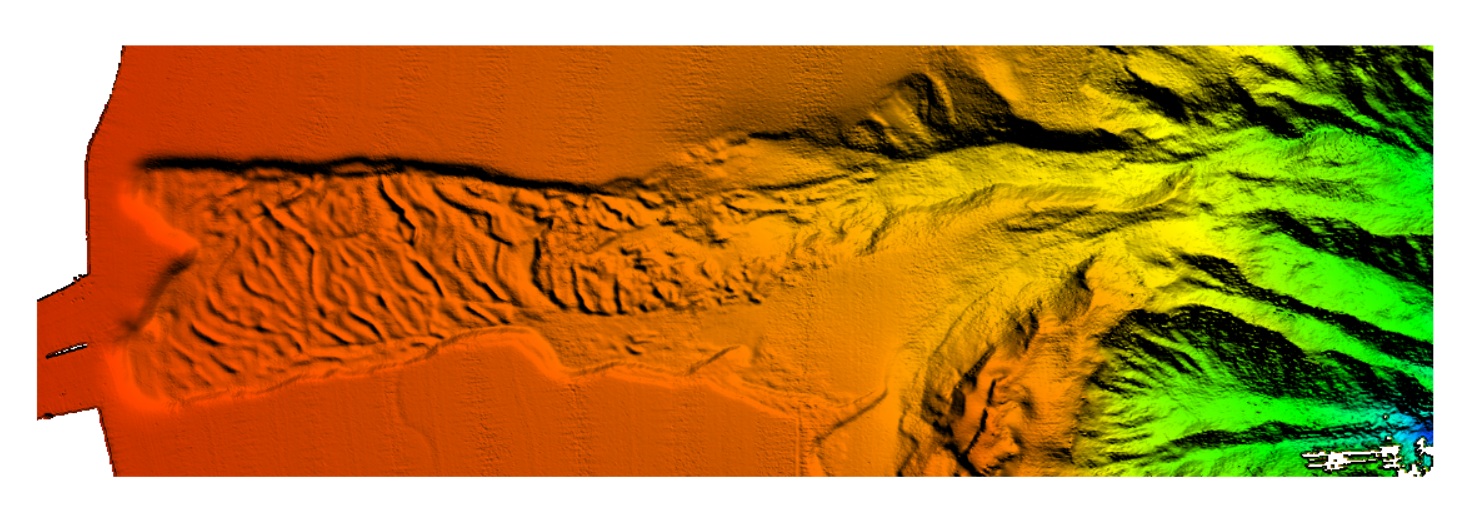
4036 HRDTM 1/128 Landslide Cumecs
The data were acquired with a Simrad EM710 Multi Beam echosounder onboard the R/V Urania in order to cover the outer Malta Plateau and upper Malta Escarpment for a geological survey in the framework of EU FP7 project EUROFLEETS. The data were published in: Micallef, A., Georgiopoulou, A., Le Bas, T., Mountjoy, J.J., Huvenne, V., Lo Iacono, C., 2013. The Malta-Sicily Escarpment: Mass Movement dynamics in a sediment-undersupplied margin, in: Krastel, S., Berhmann, J.H., Volker, D., Stipp, M., Berndt, C., Urgeles, R., Chaytor, J.D., Huhn, K., Strasser, M., Harbitz, C.B. (Eds.), Submarine Mass Movements and Their Consequences. Springer International Publishing, Switzerland, pp. 317-328.
|
|
Citation proposal
Marine Geology and Seafloor Surveying group, Department of Geosciences, University of Malta. 4036 HRDTM 1/128 Landslide Cumecs. https://services.mspdata.eu:/geonetwork/srv/api/records/SDN_CPRD_4036_CUMECS_Landslide_Cumecs |
Simple
- Alternate title
-
KN172L08 SeaBeam 3012-P1 Bathymetry Grid
- Date ( Creation )
- Invalid DateT00:00:00
- Date ( Revision )
- Invalid DateT00:00:00
- Identifier
-
CUMECS_Landslide_Cumecs
Originator
115, Maths and Physics Building
Msida
MSD 2080
Malta
- Website
- web site
Custodian
115, Maths and Physics Building
Msida
MSD 2080
Malta
- Website
- web site
- Project name ( Theme )
-
-
EMODNet Bathymetry
-
- SeaDataNet device categories ( Theme )
-
-
multi-beam echosounders
,multi-beam echosounders
-
- SeaDataNet device categories ( Theme )
-
-
Differential Global Positioning System receivers
-
- Parameter Discovery Vocabulary (P02) ( parameter )
-
-
Bathymetry and Elevation
-
- GEMET - INSPIRE themes, version 1.0 ( Theme )
-
-
Hydrography
-
- Use limitation
- Access constraints
- by negotiation
- Use constraints
- Copyright
- Other constraints
-
EMODnet Bathymetry consortium (2020), EMODnet Digital High Resolution DTM
- Use limitation
- Spatial representation type
- Grid
- Denominator
- 50000
- Distance
- 0.0078125 Arc minute
- Metadata language
- English
- Character set
- UTF8
- Topic category
-
- Oceans
))
- Unique resource identifier
- Description
-
Map projection parameters, values and units :
Axes units :
UPPER LEFT X=29.3054583250
UPPER LEFT Y=44.6262830219
LOWER RIGHT X=40.7816282263
LOWER RIGHT Y=41.2281769950
WEST LONGITUDE=29° 18' 19.6500" E
NORTH LATITUDE=44° 37' 34.6189" N
EAST LONGITUDE=40° 46' 53.8616" E
SOUTH LATITUDE=41° 13' 41.4372" N
PROJ_DESC=Geographic (Latitude/Longitude) / WGS84 / arc degrees
PROJ_DATUM=WGS84
PROJ_UNITS=arc degrees
EPSG_CODE=4326
COVERED AREA=353215 sq km
- Geographic identifier
-
EPSG
/WGS84 / Geographic coordinate system
/7.4
- Reference system identifier
-
EPSG
/WGS 84 (EPSG:4326)
/7.4
- Number of dimensions
- 3
- Dimension name
- Column
- Dimension size
- 362
- Dimension name
- Row
- Dimension size
- 1171
- Dimension name
- Time
- Dimension size
- 1
- Cell geometry
- Point
- Transformation parameter availability
- false
- Checkpoint Availability
- false
- Point in Pixel
-
- Center
- Distribution format
-
-
XYZ Ascii
()
-
Distributor
115, Maths and Physics Building
Msida
MSD 2080
Malta
- Website
- web site
- Transfer size
- 31
- Hierarchy level
- Dataset
Vertical extent
- Minimum value
- -150
- Maximum value
- 1353
Vertical CS
Vertical datum
- Statement
-
no information
- Hierarchy level
- Feature
- Dataset
-
accuracy
Gridded data positional accuracy
- Name of measure
-
horizontal accuracy
- Measure identification
-
horizontal accuracy of coordinate
- Measure description
- Evaluation method description
Quantitative result
- Value type
- horizontal accuracy
Quantitative attribute accuracy
- Name of measure
-
depth
- Measure identification
-
depth accuracy
- Measure description
- Evaluation method description
Quantitative result
- Value
- not defined
Conformance result
- Date
- Explanation
- Hierarchy level
- Software
- Description
-
MB-System
- Other
-
software
- Hierarchy level
- Property type
- Description
-
parameters of data processing
- Attributes
- Statement
-
EMODnet processing methodology using Globe software
- Description
-
4036_CUMECS
- Hierarchy level
- Dataset
Absolute external positional accuracy
- Name of measure
-
emodnet-bathymetry.QI.Horizontal
- Value
- 3 - < 20 m
Absolute external positional accuracy
- Name of measure
-
emodnet-bathymetry.QI.Vertical
- Value
- 4 - MBES High frequency (higher that 100kHz) (1+0.5%d)
Domain consistency
- Name of measure
-
emodnet-bathymetry.QI.Purpose
- Value
- 2 - Bathymetric/morphologic survey
Metadata
- File identifier
- SDN_CPRD_4036_CUMECS_Landslide_Cumecs XML
- Metadata language
- English
- Character set
- UTF8
- Hierarchy level name
-
Composite Product Record
- Date stamp
- 2020-11-17T16:45:33
- Metadata standard name
-
ISO 19115:2003/19139 - EMODNET - BATHYMETRY
- Metadata standard version
-
1.0
Author
115, Maths and Physics Building
Msida
MSD 2080
Malta
- Website
- web site