Metadata catalogue
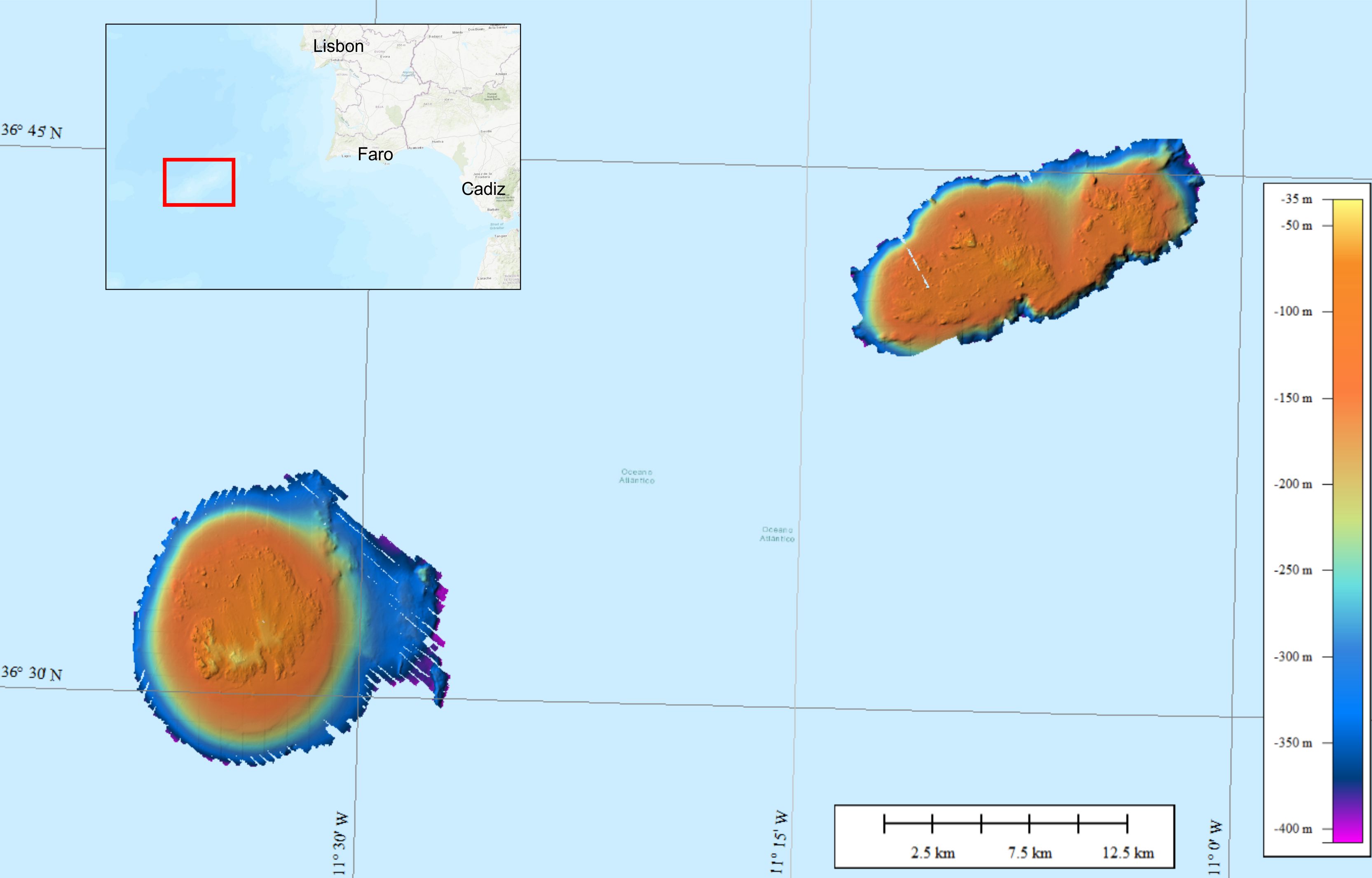
252_CNR-38-Gorringe_HR
Bathymetric data were collected on the Gorringe Bank, located along the Europe-Africa obliquely convergent plate boundary offshore SW Portugal. The high-resolution swath bathymetry dataset allowed the investigation of the shallow-depth structure of the Horseshoe Seamounts. Data were collected by means of the MBES system Reson SeaBat8101. The MBES was hull-mounted on a 60 meters long vessel. The MBES has 101 beams 1,5° x 1,5°; the operational frequency was 240 kHz. A LandStar 12 channel DGPS system was used for ship positioning and a motion sensor TSS-DMS02-05 was used to provide corrections for attitude data. A Sound Velocity Sensor was installed near the transducers thus providing realtime sound speed for beam steering. A sound velocity profiler Reson SVP20 was lowered through the water column every 6–8 h to get the velocity profile required for the depth computation. The bathymetric data were processed using the PDS2000 software. Data de-spiking was carried out without the application of automatic filters in order to preserve data accuracy and resolution.
|
|
Citation proposal
CNR, Institute for the Marine and Coastal Environment (IAMC) - Napoli. 252_CNR-38-Gorringe_HR. https://services.mspdata.eu:/geonetwork/srv/api/records/SDN_CPRD_252_CNR-38-Gorringe_HR |
Simple
- Alternate title
-
KN172L08 SeaBeam 3012-P1 Bathymetry Grid
- Date ( Creation )
- 2020-11-17T00:00:00
- Date ( Revision )
- Invalid DateT00:00:00
- Identifier
-
CNR-38-Gorringe_HR
Originator
Calata Porta di Massa
Napoli
80133
Italy
Custodian
Calata Porta di Massa
Napoli
80133
Italy
- Project name ( Theme )
-
-
EMODNet Bathymetry
-
- SeaDataNet device categories ( Theme )
-
-
multi-beam echosounders
,multi-beam echosounders
-
- SeaDataNet device categories ( Theme )
-
-
Differential Global Positioning System receivers
-
- Parameter Discovery Vocabulary (P02) ( parameter )
-
-
Bathymetry and Elevation
-
- GEMET - INSPIRE themes, version 1.0 ( Theme )
-
-
Hydrography
-
- Use limitation
-
Not for navigation
- Access constraints
- unrestricted
- Use constraints
- Copyright
- Other constraints
-
EMODnet Bathymetry consortium (2020) EMODnet Digital High Resolution DTM
- Use limitation
-
not suitable for navigation
- Spatial representation type
- Grid
- Denominator
- 50000
- Distance
- 0.9375 Arc second
- Metadata language
- English
- Character set
- UTF8
- Topic category
-
- Oceans
))
- Unique resource identifier
- Description
-
Map projection parameters, values and units :
Axes units :
UPPER LEFT X=29.3054583250
UPPER LEFT Y=44.6262830219
LOWER RIGHT X=40.7816282263
LOWER RIGHT Y=41.2281769950
WEST LONGITUDE=29° 18' 19.6500" E
NORTH LATITUDE=44° 37' 34.6189" N
EAST LONGITUDE=40° 46' 53.8616" E
SOUTH LATITUDE=41° 13' 41.4372" N
PROJ_DESC=Geographic (Latitude/Longitude) / WGS84 / arc degrees
PROJ_DATUM=WGS84
PROJ_UNITS=arc degrees
EPSG_CODE=4326
COVERED AREA=353215 sq km
- Geographic identifier
-
EPSG
/WGS84 / Geographic coordinate system
/7.4
- Reference system identifier
-
EPSG
/WGS 84 (EPSG:4326)
/7.4
- Number of dimensions
- 3
- Dimension name
- Column
- Dimension size
- 2368
- Dimension name
- Row
- Dimension size
- 1216
- Dimension name
- Time
- Dimension size
- 1
- Cell geometry
- Point
- Transformation parameter availability
- false
- Checkpoint Availability
- false
- Point in Pixel
-
- Upper left
- Distribution format
-
-
NetCDF
()
-
Distributor
Calata Porta di Massa
Napoli
80133
Italy
Distributor
- OnLine resource
- EMDOnet viewer
- Hierarchy level
- Dataset
Vertical extent
- Minimum value
- 34.76
- Maximum value
- 407.72
Vertical CS
Vertical datum
- Statement
-
no information
- Hierarchy level
- Feature
- Dataset
-
accuracy
Gridded data positional accuracy
- Name of measure
-
horizontal accuracy
- Measure identification
-
horizontal accuracy of coordinate
- Measure description
- Evaluation method description
Quantitative result
- Value type
- horizontal accuracy
Quantitative attribute accuracy
- Name of measure
-
depth
- Measure identification
-
depth accuracy
- Measure description
- Evaluation method description
Quantitative result
- Value
- not defined
Conformance result
- Date
- Explanation
- Hierarchy level
- Software
- Description
-
MB-System
- Other
-
software
- Hierarchy level
- Property type
- Description
-
parameters of data processing
- Attributes
- Statement
-
EMODnet processing methodology using Globe software
- Description
-
Dataset was collected by means of a multibeam echosounder. The HR DTM was generated from CDI 252_CNR-IAMC-38
- Hierarchy level
- Dataset
Absolute external positional accuracy
- Name of measure
-
emodnet-bathymetry.QI.Horizontal
- Value
- 3 - < 20 m
Absolute external positional accuracy
- Name of measure
-
emodnet-bathymetry.QI.Vertical
- Value
- 4 - MBES High frequency (higher that 100kHz) (1+0.5%d)
Domain consistency
- Name of measure
-
emodnet-bathymetry.QI.Purpose
- Value
- 2 - Bathymetric/morphologic survey
Metadata
- File identifier
- SDN_CPRD_252_CNR-38-Gorringe_HR XML
- Metadata language
- English
- Character set
- UTF8
- Hierarchy level name
-
Composite Product Record
- Date stamp
- 2020-11-19T10:37:34
- Metadata standard name
-
ISO 19115:2003/19139 - EMODNET - BATHYMETRY
- Metadata standard version
-
1.0
Author
Calata Porta di Massa
Napoli
80133
Italy