Metadata catalogue
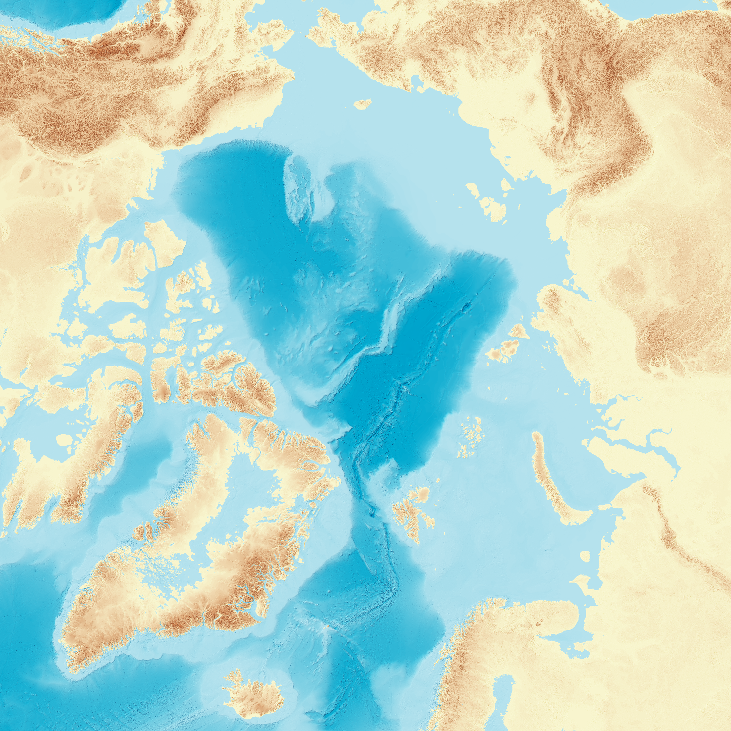
IBCAO v. 5 (International Bathymetric Chart of the Arctic Ocean version 5)
Knowledge about seafloor depth, or bathymetry, is crucial for various marine activities, including scientific research, offshore industry, navigation, and ocean exploration. Mapping the central Arctic Ocean is challenging due to the presence of perennial sea ice, which limits data collection to icebreakers, submarines, and drifting ice stations. The International Bathymetric Chart of the Arctic Ocean (IBCAO) was initiated in 1997 with the goal of updating the Arctic Ocean bathymetric portrayal. The project team has since released four versions, each improving resolution and accuracy. Here, we present IBCAO Version 5.0, which offers a resolution four times as high as Version 4.0, with 100 × 100 m grid cells compared to 200 × 200 m. Over 25 % of the Arctic Ocean is now mapped with individual depth soundings, based on a criteria for what is considered mapped that depends on water depth. Version 5.0 also represents significant advancements in data compilation and computing techniques. Despite these improvements, challenges such as sea-ice cover and political dynamics still hinder comprehensive mapping.
|
|
Citation proposal
Stockholm University, Department of Geological Sciences. IBCAO v. 5 (International Bathymetric Chart of the Arctic Ocean version 5). https://services.mspdata.eu:/geonetwork/srv/api/records/SDN_CPRD_2210_IBCAO_5 |
Simple
- Alternate title
- Date ( Creation )
- 2024-07-01
- Date ( Revision )
- 2024-07-01
- Identifier
-
IBCAO_5
Custodian
Svante Arrhenius vag 8
Stockholm
106 91
Sweden
- Website
- web site
Originator
Svante Arrhenius vag 8
Stockholm
106 91
Sweden
- Website
- web site
- Project name ( Theme )
-
-
EMODNet Bathymetry
-
- SeaDataNet device categories ( Theme )
-
-
single-beam echosounders
,multi-beam echosounders
,gravimeters
,optical backscatter sensors
,bathymetric LiDARs
-
- http://vocab.ndg.nerc.ac.uk/ ( Stratum )
-
- Parameter Discovery Vocabulary (P02) ( parameter )
-
-
Bathymetry and Elevation
-
- GEMET - INSPIRE themes, version 1.0 ( Theme )
-
-
Hydrography
-
- SeaDataNet depth measurement reference planes ( Theme )
-
-
mean sea level
-
- Use limitation
-
Please acknowledge the following citation when using the IBCAO grids and maps:
To be announced. (Jakobsson et al. (2024), in review)
- Access constraints
- Creative Commons Attribution 4.0 International
- Use constraints
- Creative Commons Attribution 4.0 International
- Other constraints
- Use limitation
-
Not to be used for navigation.
- Spatial representation type
- Grid
- Denominator
- 10000
- Distance
- 100 meter
- Metadata language
- English
- Character set
- UTF8
- Topic category
-
- Oceans
))
- Unique resource identifier
- Description
-
Map projection parameters, values and units :
Axes units :
- Unique resource identifier
- Codespace
-
EPSG
- Version
-
7.4
- Reference system identifier
-
EPSG
/WGS 84 / IBCAO Polar Stereographic (EPSG:3996)
/8.6
- Number of dimensions
- 3
- Dimension name
- Column
- Dimension size
- 58200
- Dimension name
- Row
- Dimension size
- 58200
- Dimension name
- Time
- Dimension size
- 1
- Cell geometry
- Point
- Transformation parameter availability
- false
- Checkpoint Availability
- false
- Point in Pixel
-
- Center
- Distribution format
-
-
GeoTIFF
(1.0
)- Specification
-
Distributor
Distributor
Svante Arrhenius vag 8
Stockholm
106 91
Sweden
- Website
- web site
- Transfer size
- 11400
- Protocol
-
WWW:LINK
- Name
- Description
- Function
- Information
- OnLine resource
- EMODnet Bathymetry WMTS service
- Hierarchy level
- Dataset
Vertical extent
- Minimum value
- 0
- Maximum value
- 5489
Vertical CS
Vertical datum
- Statement
-
no information
- Hierarchy level
- Feature
- Dataset
-
accuracy
Gridded data positional accuracy
- Name of measure
-
horizontal accuracy
- Measure identification
-
horizontal accuracy of coordinate
- Measure description
- Evaluation method description
Quantitative result
- Value type
- horizontal accuracy
Quantitative attribute accuracy
- Name of measure
-
depth
- Measure identification
-
depth accuracy
- Measure description
- Evaluation method description
Quantitative result
- Value
- not defined
Conformance result
- Date
- Explanation
- Pass
- false
- Hierarchy level
- Software
- Description
- Other
-
software
- Hierarchy level
- Property type
- Description
-
parameters of data processing
- Attributes
- Statement
-
Data is collected by Stockholm University, analysed and cleaned by data processors, and combined into a grid with smoothing and interpolation methods to fill in blank regions without data.
- Description
-
IBCAO Version 5 contains data from numerous sources and mapping methods, totalling roughly 1400 datasets. A majority of these are multibeam and single-beam datasets from research cruises, though they also include measurements from isolated soundings, lidar, optics, gravity data, interpolations, bathymetric charts, pre-generated grids, and steering points.
- Hierarchy level
- Dataset
Absolute external positional accuracy
- Name of measure
-
emodnet-bathymetry.QI.Horizontal
- Value
- -1 - Multisources
Absolute external positional accuracy
- Name of measure
-
emodnet-bathymetry.QI.Vertical
- Value
- -1 - Multisources
Domain consistency
- Name of measure
-
emodnet-bathymetry.QI.Purpose
- Value
- 2 - Bathymetric
Metadata
- File identifier
- SDN_CPRD_2210_IBCAO_5 XML
- Metadata language
- English
- Character set
- UTF8
- Hierarchy level name
-
Product record
- Date stamp
- 2024-09-10T09:54:20.671Z
- Metadata standard name
-
ISO 19115:2003/19139 - EMODNET - BATHYMETRY
- Metadata standard version
-
1.0
Author
Svante Arrhenius vag 8
Stockholm
106 91
Sweden
- Website
- web site