Metadata catalogue
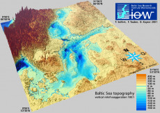
IOWTOPO2 - A high resolution spherical grid topography of the Baltic Sea
The data sets presented here provide a digitised topography of the Baltic Sea.
Land heights and water depths have been calculated for two regular spherical grids from available data. Data set "iowtopo2" covers the whole Baltic Sea from 9° to 31° East and from 53°30’ to 66° North by (660 x 750) grid cells, see Fig. 1. The resolution is 2 minutes with respect to longitude, and 1 minute to latitude. This is approximately 1 nautical mile, or 2 km resp. The region of the Belt Sea from 9° to 15°10’ East and from 53°30’ to 56°30’ North, see Fig 2, is comprised within data set "iowtopo1" with a twofold higher resolution (1 minute in longitude and 0.5 minutes in latitude corresponding to approx. 1 km).
The data specify a representative average of the water depth or the land height of each grid cell, counted by negative and positive values in meters. Some statistical parameters allow a rough estimate of the reliability of the data. (Please be aware that data are rather uncertain in regions where strong gradients of the bottom relief occur, esp. the northern parts of the Baltic. There is an urgent need of further bathymetry data to become available for the Baltic beyond 59° North.) Since a common average of land heights and water depths lead to rather unsatisfying results with respect to the gridded shoreline, a landmask is proposed in both data sets. The landmasks were derived from the global high resolution shorelines GSHHS and RANGS, and used to get a "naturally looking" composite topography (z_topo see
below).
Citation: T. Seifert, F. Tauber, B. Kayser: 2001: "A high resolution spherical grid topography of the Baltic Sea – 2nd edition", Baltic Sea Science Congress, Stockholm 25-29. November 2001, Poster #147,
|
|
Citation proposal
Baltic Sea Research Institute Warnemuende (IOW), Marine Geology. IOWTOPO2 - A high resolution spherical grid topography of the Baltic Sea. https://services.mspdata.eu:/geonetwork/srv/api/records/SDN_CPRD_116_IOWTOPO2 |
Simple
- Alternate title
- KN172L08 SeaBeam 3012-P1 Bathymetry Grid
- Date ( Creation )
- 2001-11-27T00:00:00
- Date ( Revision )
- 2008-01-16T00:00:00
- Identifier
- IOWTOPO2
Originator
Custodian
- Project name ( Theme )
-
- EMODNet Bathymetry
- SeaDataNet device categories ( Theme )
-
- multi-beam echosounders , multi-beam echosounders
- SeaDataNet device categories ( Theme )
-
- Differential Global Positioning System receivers
- Parameter Discovery Vocabulary (P02) ( parameter )
-
- Bathymetry and Elevation
- GEMET - INSPIRE themes, version 1.0 ( Theme )
-
- Hydrography
- Use limitation
- These data sets are a piece of scientific work which relies on free interchange of scientific data. Therefore the data are available for scientific research. The data must not be used for navigation.
- Access constraints
- License
- Use constraints
- Copyright
- Other constraints
- CC-BY (Creative Commons - Attribution)
- Use limitation
- These data sets are a piece of scientific work which relies on free interchange of scientific data. Therefore the data are available for scientific research. The data must not be used for navigation.
- Distance
- 1000 Metres (m)
- Metadata language
- English
- Character set
- UTF8
- Topic category
-
- Oceans
))
- Unique resource identifier
- Description
-
Map projection parameters, values and units :
Axes units :
UPPER LEFT X=29.3054583250
UPPER LEFT Y=44.6262830219
LOWER RIGHT X=40.7816282263
LOWER RIGHT Y=41.2281769950
WEST LONGITUDE=29° 18' 19.6500" E
NORTH LATITUDE=44° 37' 34.6189" N
EAST LONGITUDE=40° 46' 53.8616" E
SOUTH LATITUDE=41° 13' 41.4372" N
PROJ_DESC=Geographic (Latitude/Longitude) / WGS84 / arc degrees
PROJ_DATUM=WGS84
PROJ_UNITS=arc degrees
EPSG_CODE=4326
COVERED AREA=353215 sq km
- Geographic identifier
- EPSG / WGS84 / Geographic coordinate system / 7.4
- Number of dimensions
- 3
- Dimension name
- Column
- Dimension name
- Row
- Dimension name
- Time
- Dimension size
- 1
- Cell geometry
- Point
- Transformation parameter availability
- false
- Checkpoint Availability
- false
- Point in Pixel
-
- Distribution format
-
- NetCDF ( )
Distributor
- Hierarchy level
- Dataset
Vertical extent
Vertical CS
Vertical datum
- Statement
- no information
- Hierarchy level
- Feature
- Dataset
- accuracy
Gridded data positional accuracy
- Name of measure
- horizontal accuracy
- Measure identification
- horizontal accuracy of coordinate
- Measure description
- Evaluation method description
Quantitative result
- Value type
- horizontal accuracy
Quantitative attribute accuracy
- Name of measure
- depth
- Measure identification
- depth accuracy
- Measure description
- Evaluation method description
Quantitative result
- Value
- not defined
Conformance result
- Date
- Explanation
- Hierarchy level
- Software
- Description
- MB-System
- Other
- software
- Hierarchy level
- Property type
- Description
- parameters of data processing
- Attributes
- Statement
-
Data are provided in two formats. NetCDF files (*.nc) are self-desribing binaries which may be visualised and processed by tools like Ferret, Grads or Matlab. Alternatively rather big ascii files (*.dat) are given which start with two header lines and contain the following data:
xlon: the geographic longitude of the grid cell centre
ylat: the corresponding geographical latitude
z_topo: land height/water depth, composite of z_water, z_land and the proposed landmask
z_water: average of all water depths allocated from original data to this grid cell
z_land: average of land heights allocated to this grid cell from edcdaac.usgs.gov/gtopo30/gtopo30.html data
z_min: minimal value of the original data
z_max: maximal value of the original data
z_stdev: standard deviation of original data from averages z_water/z_land
z_near: datum lying nearest to the centre of this grid cell
d-near: distance of above mentioned data point from centre of grid cell
n_wet:
> 0: number of original water depths allovated to this grid cell
< 0: number of neighbors interpolated to fill this empty cell
n_dry:
> 0: number of original land heights allocated to this cell
< 0: number of iterations to find direct neighbours for interpolation
landmask: proposed "naturally loking" landmask (land=0, water=1)
flag: flag indicating a pure data average (0), or an interpolated/masked land height (+1) or water depth (-1)
Updates
1. Update from 01.05.2002
Addendum 19.07.2002
2. Update from 31.01.2003
3. Update from 30.05.2007
4. Update from 16.01.2008
A short description of the data compilation has been published on-line: https://www.io-warnemuende.de/topography-of-the-baltic-sea-data-compilation.html
- Description
- Hierarchy level
- Dataset
Absolute external positional accuracy
- Name of measure
- emodnet-bathymetry.QI.Horizontal
- Value
- -1 - Multisources
Absolute external positional accuracy
- Name of measure
- emodnet-bathymetry.QI.Vertical
- Value
- -1 - Multisources
Domain consistency
- Name of measure
- emodnet-bathymetry.QI.Purpose
- Value
- 2 - Bathymetric/morphologic survey
Metadata
- File identifier
- SDN_CPRD_116_IOWTOPO2 XML
- Metadata language
- English
- Character set
- UTF8
- Hierarchy level name
- Composite Product Record
- Date stamp
- 2020-11-24T09:28:09
- Metadata standard name
- ISO 19115:2003/19139 - EMODNET - BATHYMETRY
- Metadata standard version
- 1.0