 Metadata catalogue
Litto3D® - Saint-Martin 2019
|
|
Citation proposal
Shom. Litto3D® - Saint-Martin 2019. https://services.mspdata.eu:/geonetwork/srv/api/records/BATHYMETRIE_LITTO3D_STMARTIN_2019.xml |
Simple
- Alternate title
- Land-sea altimetric database
- Date ( Creation )
- 2021-10-27
- Presentation form
- Digital map
- Purpose
-
The main aim is to produce precise digital data with unrivalled resolution (decimetric precision, metric resolution) for French coastal terrain. This solution provides the basic data required to implement many applications and public policies, such as:
• Risk prevention (tsunamis, cyclone swell, rising sea level due to global warming, coastal flooding, flooding, erosion, etc.),
• Coastal planning studies (roads, ports, etc.),
• improved knowledge of the public maritime territory, tracking coastal withdrawal,
• mapping terrestrial and marine habitats,
• creating current models and related applications (tidal and swell current energy, waste dispersal at sea, sedimentary movements, etc.)
• Integrated Coastal Zone Management (ICZM).
- Credit
- This approach is led by Shom (Service Hydrographique et Océanographique de la Marine - Oceanography and Hydrography Service of the French Navy) and IGN (French institute for geographical and forestry information), in partnership with French State (DEAL Guadeloupe).
Author
- Maintenance and update frequency
- Irregular
- Keywords ( Theme )
-
- Product , open data
- GEMET - INSPIRE themes, version 1.0 ( Theme )
-
- Altitude Elevation
- Use limitation
- Data may be freely used providing that the source is mentioned as follows "Shom-IGN, 2019. http://dx.doi.org/10.17183/L3D_SAINT_MARTIN_2019".
- Use limitation
- Open licence Etalab v. 2.0 avril 2017.
- Use limitation
- Do not use for navigation
- Use limitation
- Data may be freely used providing that the source is mentioned as follows "Shom-IGN, 2019. http://dx.doi.org/10.17183/L3D_SAINT_MARTIN_2019".
- Access constraints
- License
- Use constraints
- Other restrictions
- Other constraints
- Open licence Etalab v. 2.0 avril 2017.
- Access constraints
- Other restrictions
- Other constraints
- Pas de restriction d'accès public. No public access restrictions.
- Classification
- Unclassified
- Spatial representation type
- Grid
- Distance
- 1 m
- Metadata language
- fre French
- Character set
- utf8 UTF8
- Topic category
-
- Elevation
- Description
- France, Saint-Martin
))
- Distribution format
-
- ASC (inapplicable )
- XYZ (inapplicable )
Distributor
- OnLine resource
-
Shom geoportal
Shom geoportal
- OnLine resource
-
LITTO3D_STMARTIN_2019_PYR_3857_WMSR
Access point Access point
- OnLine resource
-
Shom distribution space to download data
Shom distribution space to download tiles
- Hierarchy level
- Series
Conformance result
- Date ( Publication )
- 2013-12-10
- Explanation
- Information sur la conformité aux spécifications INSPIRE du thème Altitude.
- Pass
- false
Conformance result
- Explanation
- Information sur la conformité au règlement d'interopérabilité des séries et des services de données géographiques.
- Pass
- true
- Statement
-
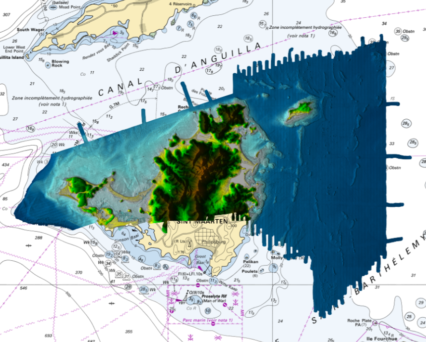
These data were acquired by airborne lidars during acquisition campaigns conducted from 15 March2019 to 28 March 2019 over the Saint-Martin (french side) and Saint-Barthélemy islands. The DEM (Digital Elevation Model) is accompanied by layers, which add local metadata. Each layer is supported by the same even mesh as the DEM. One layer provides information on the source of most data used to calculate the node, for each node, and the second layer provides information on the evaluation of the distance between the node in question and the different known points used to calculate altitude.
The airborne survey was provided using "Leica HawkEye 4X system (HE4X)".
Metadata
- File identifier
- BATHYMETRIE_LITTO3D_STMARTIN_2019.xml XML
- Metadata language
- fre French
- Character set
- UTF8
- Hierarchy level
- Series
- Hierarchy level name
- Collection de données
- Date stamp
- 2021-11-24T09:07:32
- Metadata standard name
- ISO 19115:2003/19139
- Metadata standard version
- 1.0
Point of contact
Overviews
Provided by
