Metadata catalogue
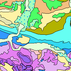
Title translated: Geological Map of Germany 1:1,000,000 (WMS)
The Geological Map of Germany 1:1,000,000 (GK1000) represents the geology of Germany and adjacent areas. The Quaternary units of Northern Germany and the Alpine foreland are described by their genesis.The older sedimentary rocks are classified by age (stratigraphy); igneous and metamorphic rocks are classified by their composition (lithology).
|
|
Citation proposal
(1993) . Title translated: Geological Map of Germany 1:1,000,000 (WMS). https://services.mspdata.eu:/geonetwork/srv/api/records/ADB575F8-6BA6-48B6-A1EB-9D5980935F37 |
Simple
Identification info
- Alternate title
- GK1000 (WMS)
- Date ( Publication )
- 1993-03-16
- Date ( Revision )
- 2008-08-01
- Identifier
- 029AD1B5-6431-400B-90EF-F1B0F424FD8C
- Status
- completed Completed
Point of contact
Bundesanstalt für Geowissenschaften und Rohstoffe
-
Wiechmann, Marc Filip, Dr.
Stilleweg 2
Hannover
Niedersachsen
30655
DE
- GEMET - INSPIRE themes, version 1.0
-
- Geologie , Geology
- GEMET - Concepts, version 2.4 ( Theme )
-
- Gebirge , Geowissenschaften , Verwerfung , Gestein , Kalkstein , Kartierung , Meeressediment , Moor , Sand , Sedimentation (geologisch) , Tektonik
- SGD-Liste ( Theme )
-
- Deckgebirge , Festgestein , Sedimentgestein , Störung , Stratigraphie , Gabbro , Genese , Granit , Kristallingestein , Küstengeologie , Lockergestein , Petrographie , Quartärgeologie
- Keywords ( Theme )
-
- Entstehung , Gesteinsalter , Gesteinsart , infoMapAccessService , EGDI
- Keywords ( Place )
-
- Bundesrepublik Deutschland
- Classification
- Unclassified
- Use constraints
- otherRestrictions Other restrictions
- Other constraints
- Allgemeine Geschäftsbedingungen, siehe https://www.bgr.bund.de/AGB - General terms and conditions, see https://www.bgr.bund.de/AGB_en. Die bereitgestellten Informationen sind bei Weiterverwendung wie folgt zu zitieren: Datenquelle: GK1000, (c) BGR Hannover, 2014
- Service Type
- view
- Service Version
- OGC:WMS 1.3.0
N
S
E
W
))
Coupled Resource
- Operation Name
- getMap
- Identifier
- FD5DD44F-0217-4FBF-A307-E27B01DFBE0F
- Coupling Type
- Tight
Contains Operations
- Operation Name
- GetCapabilities
- Distributed Computing Platforms
- WebService
- Connect Point
- https://services.bgr.de/wms/geologie/gk1000/?
Contains Operations
- Operation Name
- GetMap
- Distributed Computing Platforms
- WebService
- Connect Point
- https://services.bgr.de/wms/geologie/gk1000/?
- Operates On
- Distribution format
-
- png (n/a )
- jpeg (n/a )
- gif (n/a )
- Hierarchy level
- Service
Conformance result
- Date ( Publication )
- 2009-10-20
- Explanation
- siehe dazu die angegebene Durchführungsbestimmung
- Statement
- Redaktioneller Entwurf anhand GÜK200 u. a. geol. Übersichtskarten. Digital. d. Linien (geol. Grenzen, Störungen, etc.). Flächenattribute (Stratigraphie, Petrographie, Genese) sind in einer DB beschrieben, Geometrie ist an Topographie und Maßstab angepasst -
Metadata
- File identifier
- ADB575F8-6BA6-48B6-A1EB-9D5980935F37 XML
- Metadata language
- ger German
- Character set
- utf-8 UTF8
- Hierarchy level
- service Service
- Hierarchy level name
- Geologie
- Date stamp
- 2016-11-25
- Metadata standard name
- ISO 19115/INSPIRE_TG2/CZ4
- Metadata standard version
- V. 1.2