Metadata catalogue
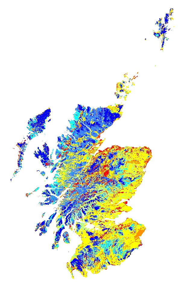
Available Water Capacity, Scotland WMS
The proportion of water held in the soil at field capacity (5KPa) and at the permanent wilting point (1500kPa) was calculated for each soil horizon of each soil taxonomic unit (soil series) delineated within the 1:250 000 national soil map of Scotland based on pedotransfer functions (regression equations using median sand, silt, clay and organic carbon contents from the Scottish soils knowledge and information base (SSKIB) derived for soils in the UK (Hollis et al., 2015). The Available Water Content for each horizon was calculated by subtracting the water content at 1500 KPa from the water content at 5 kPa. The horizon thickness was then multiplied by the available water content (mm) and summed for the entire soil profile to 1 m or rock if <1m. The map shows the average available water capacity calculated using the areal proportions of all soils in each 1:250 000 soil map unit.
Gagkas, Z., Lilly, A., Baggaley, N. & Donnelly, D. (2019). Map of available water capacity of soils in Scotland. James Hutton Institute. Aberdeen.
Please note that this dataset differs significantly to the version of Available Water Capacity published in 2012. The difference results from the use of different regression equations to predict available water capacities (Hollis et al.) and bulk densities. In addition, the data values shown are weighted averages by polygon rather than the AWC of the dominant soil type in the polygon. The earlier version of AWC was published as Lilly, A, Baggaley, N and Donnelly, D. 2012. Map of available water content to 1 metre depth in soils of Scotland. Map prepared for EU project GS-SOIL-Assessment and strategic development of INSPIRE compliant Geodata-Services for European Soil Data. ECP-2008-GEO-318004.
|
|
Citation proposal
Colin Campbell (The James Hutton Institute) (2019) . Available Water Capacity, Scotland WMS. https://services.mspdata.eu:/geonetwork/srv/api/records/71e38c05-cf6c-4732-b966-7c202e146cc4 |
Simple
Identification info
- Date ( Publication )
- 2019-03-27
- Identifier
-
AWC_Scotland
Custodian
Craigiebuckler
Aberdeen
AB15 8QH
Scotland
Principal investigator
Craigiebuckler
Aberdeen
AB15 8QH
Scotland
- Maintenance and update frequency
- irregular Irregular
- Name
-
ESRI Shapefile
- Version
-
1.0
- GEMET - INSPIRE themes, version 1.0 ( Theme )
-
-
Soil
-
- INSPIRE Service taxonomy ( Theme )
-
-
infoMapAccessService
-
- Access constraints
- otherRestrictions Other restrictions
- Other constraints
-
no limitations on public access
- Use limitation
-
The James Hutton Institute Open Data Licence
- Service Type
- view
))
Contains Operations
- Operates On
- Reference system identifier
-
EPSG
/OSGB 1936 / British National Grid (EPSG:27700)
/7.9
- Distribution format
-
-
ESRI Shapefile
(1.0
)
-
- OnLine resource
- http://DRUID.HUTTON.AC.UK/arcgis/services/Hutton_AWC_2019/MapServer/WMSServer?request=GetCapabilities&service=WMS
- OnLine resource
- Zipped ESRI shapefile
- Hierarchy level
- service Service
- Other
-
Service
- Statement
-
Please note that this dataset differs significantly to the version of Available Water Capacity published in 2012. The difference results from the use of different regression equations to predict available water capacities (Hollis et al.) and bulk densities. In addition, the data values shown are weighted averages by polygon rather than the AWC of the dominant soil type in the polygon.
The earlier version of AWC was published as Lilly, A, Baggaley, N and Donnelly, D. 2012. Map of available water content to 1 metre depth in soils of Scotland. Map prepared for EU project GS-SOIL-Assessment and strategic development of INSPIRE compliant Geodata-Services for European Soil Data. ECP-2008-GEO-318004.
- Hierarchy level
- Dataset
- Dataset
-
The available water capacity map is based on the 1:250 000 soil map and calculated using data from the Scottish Soils Knowledge and Information Base (SSKIB). The available water capacity of each soil type within a soil map unit was determined taking into account whether the soil was cultivated or not. Due to a limited amount of measured data for all soils, the water content (mm) was calculated from other soil properties such as texture and organic matter content.
Conformance result
- Date ( Publication )
- 2010-12-08
- Explanation
-
See the referenced specification
- Pass
- true
Metadata
- File identifier
- 71e38c05-cf6c-4732-b966-7c202e146cc4 XML
- Metadata language
- eng English
- Hierarchy level
- service Service
- Hierarchy level name
-
Service
- Date stamp
- 2020-04-14
- Metadata standard name
-
ISO 19115:2003/19139
- Metadata standard version
-
1.0
Point of contact
Craigiebuckler
Aberdeen
AB15 8QH
Scotland