Metadata catalogue
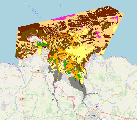
Map of intertidal habitats for the Natura 2000 FR5300015 site – Morlaix Bay
Map of benthic habitat synthesis of the Natura 2000 site FR5300015 - Bay of Morlaix is the result of the fusion and harmonization of five cartographic data. They were generated according to mapping strategies, interpretation scales and on the basis of different cartographic supports.
|
|
Citation proposal
Touria Bajjouk Touria Bajjouk (IFREMER IFREMER ) - Anouar Hamdi Anouar Hamdi (Auto-entrepreneur Auto-entrepreneur ) - Bernard Maud Bernard Maud (IFREMER IFREMER ) (2019) . Map of intertidal habitats for the Natura 2000 FR5300015 site – Morlaix Bay. IFREMER IFREMER https://services.mspdata.eu:/geonetwork/srv/api/records/57a9280a-caca-4e89-b2a0-52a2b85f8d5a |
Simple
- Alternate title
-
BMO_Synthèse_Natura_Habitats_ZSC_V1r0
- Date ( Revision )
- 2019-03-15T00:00:00
- Date ( Publication )
- 2019-01-01
- Identifier
-
FR-330-715-368-00032-SYNTHESE_NATURA2000_FR5300015_MORLAIX
- Identifier
-
DOI:10.12770/57a9280a-caca-4e89-b2a0-52a2b85f8d5a
- Presentation form
- Digital map
- Purpose
-
The goal of this work is the cartographic habitat characterization of the Natura 2000 Special Area of Conservation (SAC) site in the Bay of Morlaix.
- Credit
-
Natura 2000
- Status
- On going
Author
Centre Bretagne - ZI de la Pointe du Diable - CS 10070
Plouzané
29280
France
Publisher
- Maintenance and update frequency
- Not planned
- Thèmes Sextant Thèmes Sextant ( Theme )
-
-
/Biological Environment/Habitats
-
- Keywords ( Theme )
-
-
Habitat, Intertidal, Typology, Natura 2000, Cartography, Habitats guide, Intertidal zone
,Benthique
,Natura 2000
,Données ouvertes
,Open Data
-
- Keywords ( Place )
-
-
France, Brittany, Finistère, Morlaix, Morlaix Bay
,Baie de Morlaix
-
- GEMET - INSPIRE themes, version 1.0 GEMET - INSPIRE themes, version 1.0 ( Theme )
-
-
Habitats and biotopes
-
- Type de jeux de donnée - ODATIS Type de jeux de donnée - ODATIS ( Theme )
-
-
/Processed data/Composite products
-
- Thématiques - SIMM Thématiques - SIMM ( Theme )
-
-
/Etat du Milieu/Habitats
-
- Use limitation
-
Limitation d'utilisation : Utilisation interdite pour un usage commercial. Toute modification de cette donnée est soumise à une autorisation préalable. Pour cela veuillez prendre contact avec le laboratoire LEBCO de l'Unité DYNECO de l'Ifremer.
- Access constraints
- Other restrictions
- Use constraints
- Copyright
- Other constraints
-
Dans la bibliographie et sur les cartes, citation obligatoire de la référence suivante :
Bajjouk T., Hamdi A., Bernard M., 2019. Carte de synthèse des habitats benthiques côtiers du site Natura 2000 FR5300015 - Baie de Morlaix. Produit Ifremer/Dreal Bretagne multi-sources Rebent/Natura2000/Cartham.
- Spatial representation type
- Vector
- Denominator
- 5000
- Metadata language
- French
- Character set
- UTF8
- Topic category
-
- Biota
- Environment description
-
ArcGIS 10.0 SP3
- Description
))
- Supplemental Information
-
- SITE: name of the Natura 2000 site
- ZONE: name field areas of the site
- METHOD_NUM: method used for scanning
- SUPP_NUM: Scan media
- DATE_SUPP: date of digital file
- NOM_AUT: name of the polygon's author
- ORG_AUT: organization of the polygon's author
- COM_NUM: miscellaneous comments on polygon digitization
- VALIDATION: specifies whether the polygon has been validated
- METHOD_VAL: specifies the method used to validate
- DATE_VAL: date validation
- NOM_VAL: name of polygon's validator
- PRENOM_VAL: first name of the polygon's validator
- ORG_VAL: Orgisation of polygon's validator
- COM_VAL: various comment on the validation
- CI: confidence index of the polygon (from 1 to 3)
- COD_EUR27: generic habitat code
- LIB_EUR27: generic habitat label
- THEM_EUR27: dominant generic habitat label for a simplified symbology (without mosaic, unrestricted in terms of levels)
- COD_CH2004: elementary habitat codes (habitats guide 2004)
- LIB_CH2004: elementary habitat's label (habitats guide 2004)
- THEM_CH04: dominant elementary habitat's label for a simplified symbology (without mosaic, unrestricted in terms of levels)
- LIB_NP09N1: Level 1 habitat label with the new proposed mapping typology (version 2011).
- THEM_NIV1: Level 1 dominant habitat with the new proposed mapping typology (version 2011).
- LIB_NP09N2: Level 2 habitat label with the new proposed mapping typology(version 2011).
- THEM_NIV2: Level 2 dominant habitat with the new proposed mapping typology (version 2011).
- LIB_NP09N3: Level 3 habitat label with the new proposed mapping typology (version 2011).
- THEM_NIV3: Level 3 dominant habitat with the new proposed mapping typology (version 2011).
- SUBSTRAT : description of the nature of the substrate corresponding to the polygon
- BIOCENOSE : description of the biota present in the area bounded by the polygon
- SURF_M2 : surface of the polygon m²
- SURF_HA : surface of the polygon ha (hectare)
- COMMENT : How to; Additional information
- Reference system identifier
-
EPSG
/RGF93 / Lambert-93 (EPSG:2154)
/8.6
- Topology level
- Geometry only
- Geometric object type
- Surface
Distributor
- Name
-
ESRI Shapefile
- Version
-
10.0
- OnLine resource
- IFR_HABITATS_BENTHIQUES_MORLAIX_2019_P
- Protocol
-
FILE
- Name
-
IFR_HABITATS_BENTHIQUES_MORLAIX_2019_P
- Description
-
Téléchargement par le panier
- OnLine resource
-
IFR_HABITATS_BENTHIQUES_MORLAIX_2019_P
Téléchargement en WFS
- OnLine resource
-
DOI du jeu de donnée
DOI du jeu de donnée
- Hierarchy level
- Dataset
Conformance result
- Date ( Publication )
- 2010-05-03
- Explanation
-
Non évalué
- Pass
- false
- Statement
-
This study was conducted from multiple shapefiles provided by Ifremer
- Delimitation of the Natura 2000 FR5300015 site at the Bay of Morlaix, entitled "AncienneEmpriseNatura2000Lb93.shp"
- The SHOM coastline, in the study area entitled "TraitCoteShom25_extrait.shp"
- Delimitation of the area conducted by Ifremer at Térénez entitled "Emprise_Terenez_rebent.shp" and that of the subtidal area entitled "carte_AEhrhold_morlaix_emprise_approxlb93.shp."
Other files allowed for additional information, such as the one on Brittany seagrass "ifr_suiviHerbier_Bretagne2007_l93.shp"
There are three raster images used for habitat photo-interpretation:
Ortholittorales-2000 (dalle40.ecw and dalle41.ecw), available online on the GeoPortal,
- BD Ortho 2005 (29-2005-0130-2420-LA2E-C07.ecw to 29-2005-0145-2435-LA2E-C07.ecw), belonging to the GEOMER laboratory, in partnership with the CETE Normandy
- Blom-2008 (morlaix_mos_extrait.img) belonging to Ifremer
Metadata
- File identifier
- 57a9280a-caca-4e89-b2a0-52a2b85f8d5a XML
- Metadata language
- French
- Character set
- UTF8
- Hierarchy level
- Dataset
- Date stamp
- 2019-11-27T10:26:29
- Metadata standard name
-
ISO 19115:2003/19139 - SEXTANT
- Metadata standard version
-
1.0
Point of contact
Centre Bretagne - ZI de la Pointe du Diable - CS 10070 - 29280 Plouzané
Brest
France