Metadata catalogue
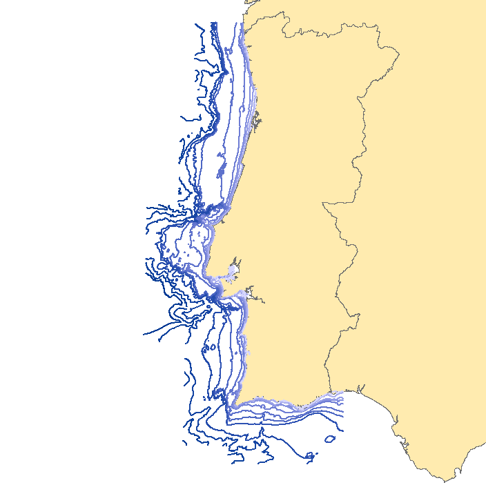
Bathymetric model off Portugal mainland
This dataset contains the isobaths extracted from the coastal or approach nautical charts - scale 1:150000: charts 24201 to 24206 - from Caminha to the mouth of the Guadiana river.
The isobathymetric lines represented at this scale are: 0, 10, 20, 30, 50, 100, 200, 500, 1000, 2000, 3000 and 4000m.
|
|
Citation proposal
(2010) . Bathymetric model off Portugal mainland. https://services.mspdata.eu:/geonetwork/srv/api/records/5008E7C6-F6B3-4A82-A30E-0785BAC3F862 |
Simple
- Alternate title
-
Linhas isobatimétricas de Portugal Continental
- Date ( Creation )
- 2010-11-10
- Date ( Revision )
- 2010-11-10
- Date ( Publication )
- 2010-11-10
- Identifier
-
PT-IH-04
- Identifier
-
5008E7C6-F6B3-4A82-A30E-0785BAC3F862
- Status
- Concluído Completed
Point of contact
- Website
- http://www.hidrografico.pt
Originator
- Website
- http://www.hidrografico.pt
- Maintenance and update frequency
- Não Planeada Not planned
- GEMET - INSPIRE themes, version 1.0 ( Theme )
-
-
Altitude
-
- Keywords ( Theme )
-
-
INSPIRECORE
-
- Keywords ( Theme )
-
-
IH
-
- Keywords ( Theme )
-
-
Isobaths
-
- Keywords ( Theme )
-
-
Isobathymetric lines
-
- Keywords ( Theme )
-
-
Portuguese Hydrographical Zero (ZH)
-
- Keywords ( Theme )
-
-
Nautical charts
-
- Keywords ( Theme )
-
-
Bathymetry
-
- Keywords ( Theme )
-
-
Oceanography
-
- Keywords ( Theme )
-
-
DL_180_2009_Art20_2e
-
- Thesaurus SNIMar v.1.x ( parameter )
-
-
Isóbata
-
- Thesaurus SNIMar v.1.x ( Discipline )
-
-
Oceanografia
-
- Thesaurus SNIMar v.1.x ( Discipline )
-
-
Batimetria e Geomorfologia Marinha
-
- Thesaurus SNIMar v.1.x ( parameter )
-
-
Batimetria
-
- Thesaurus SNIMar v.1.x ( parameter )
-
-
Carta náutica
-
- Thesaurus SNIMar v.1.x ( parameter )
-
-
Profundidade
-
- Thesaurus SNIMar v.1.x ( parameter )
-
-
Levantamento Hidrográfico
-
- Thesaurus SNIMar v.1.x ( parameter )
-
-
Zero Hidrográfico
-
- Use limitation
-
Com restrições
- Access constraints
- Outras Restrições Other restrictions
- Use constraints
- Direitos de Propriedade Intelectual Intellectual property rights
- Other constraints
-
Estes dados não podem ser utilizados para fins comerciais, mas apenas para fins de utilização pessoal e/ou para fins de investigação e deve ser sempre feita referência à sua origem, no caso de serem utilizados na produção de publicações científicas.
- Other constraints
-
Estes dados não substituem as cartas náuticas; não podem ser utilizados para navegação.
- Spatial representation type
- Vectorial Vector
- Denominator
- 150000
- Metadata language
- Português Portuguese
- Character set
- utf8 UTF8
- Topic category
-
- Oceans
- Elevation
- Environment
))
- Extent type code
- true
- Geographic identifier
-
Local
Vertical extent
- Minimum value
- 0.0
- Maximum value
- 4000.0
- Reference system identifier
-
EPSG
/
- Distribution format
-
-
Autocad DWG/DXF
(N/A
) -
ESRI Shapefile
(N/A
) -
GeoTIFF
(N/A
)
-
Distributor
- Transfer size
- 15.4
- OnLine resource
- http://www.hidrografico.pt/op/33
- Hierarchy level
- Conjunto de Dados Geográficos Dataset
Conformance result
- Date ( Publication )
- 2010-12-08
- Explanation
-
Ver a especificação citada.
- Pass
- false
- Statement
-
The isobaths resulted from the compilation of the lines represented in the latest editions of the nautical charts (Coastal or Approach Series):
>> 24201 - Caminha a Aveiro;
>> 24202 - Aveiro a Peniche;
>> 24203 - Nazaré a Lisboa;
>> 24204 - Cabo da Roca ao Cabo de Sines;
>> 24205 - Cabo de Sines a Lagos; and
>> 24206 - Cabo de S. Vicente à foz do Guadiana.
Depth values are referred to the Portuguese Hydrographical Zero (ZH).
The Portuguese Hydrographical Zero is an established reference plane, situated below the Lowest Astronomical Tide level, which is used as a reference for the soundings and isobath represented on the charts. In Portugal mainland the ZH is set 2.00 m below the adopted mean sea level - Cascais 1938.
- Description
-
Cartas náuticas da Série Costeira ou de Aproximação: 24201 - Caminha a Aveiro, 24202 - Aveiro a Peniche, 24203 - Nazaré a Lisboa, 24204 - Cabo da Roca ao Cabo de Sines, 24205 - Cabo de Sines a Lagos, 24206 - Cabo de S. Vicente à Foz do Guadiana
Metadata
- File identifier
- 5008E7C6-F6B3-4A82-A30E-0785BAC3F862 XML
- Metadata language
- Português Portuguese
- Character set
- utf8 UTF8
- Hierarchy level
- Conjunto de Dados Geográficos Dataset
- Date stamp
- 2019-03-26
- Metadata standard name
-
Perfil SNIMar
- Metadata standard version
-
v.0.9.3
Point of contact
- Website
- http://www.hidrografico.pt