Metadata catalogue
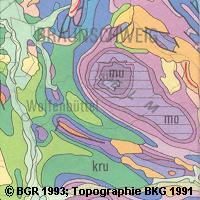
Geological Map of Germany 1:1,000,000 (GK1000)
The Geological Map of Germany 1:1,000,000 (GK1000) represents the geology of Germany and adjacent areas. The Quaternary units of Northern Germany and the Alpine foreland are described by their genesis.The older sedimentary rocks are classified by age (stratigraphy); igneous and metamorphic rocks are classified by their composition (lithology).
|
|
Citation proposal
(2006) . Geological Map of Germany 1:1,000,000 (GK1000). https://services.mspdata.eu:/geonetwork/srv/api/records/1C60DDA9-EF73-47B9-9ED7-FCD22B3226C1 |
Simple
- Alternate title
-
GK1000
- Date ( Publication )
- 2006-07-15
- Identifier
-
FD5DD44F-0217-4FBF-A307-E27B01DFBE0F
Author
Author
Author
Author
Author
- Other citation details
-
Größe der gedruckte Karte: 98 x 75 cm - Size of printed map: 98 x 75 cm
- Status
- completed Completed
Point of contact
Stilleweg 2
Hannover, GERMANY/DEUTSCHLAND
30655
DE
- GEMET - INSPIRE themes, version 1.0 ( Theme )
-
-
Geologie
,Geology
-
- Keywords ( Theme )
-
-
Genese
,Petrographie
,Stratigraphie
,opendata
,EGDI
-
- Keywords ( Place )
-
-
Deutschland
-
- Classification
- Unclassified
- Use limitation
-
Allgemeine Geschäftsbedingungen, s. https://www.bgr.bund.de/agb - General Terms and Conditions, s. https://www.bgr.bund.de/agb_en
- Use limitation
-
Nutzungsbedingungen: Dieser Datensatz kann gemäß der "Nutzungsbestimmungen für die Bereitstellung von Geodaten des Bundes" ( http://www.geodatenzentrum.de/docpdf/geonutzv.pdf ) genutzt werden.
- Access constraints
- copyright Copyright
- Use constraints
- license License
- Use constraints
- otherRestrictions Other restrictions
- Other constraints
-
Nutzungsbedingungen: Dieser Datensatz kann gemäß der "Nutzungsbestimmungen für die Bereitstellung von Geodaten des Bundes" ( http://www.geodatenzentrum.de/docpdf/geonutzv.pdf ) genutzt werden.
- Other constraints
-
{"id": "geoNutz/20130319", "name": "Nutzungsbestimmungen für die Bereitstellung von Geodaten des Bundes", "url": " http://www.geodatenzentrum.de/docpdf/geonutzv.pdf ", "quelle": "Bundesanstalt für Geowissenschaften und Rohstoffe (BGR)"}
- Denominator
- 1000000
- Metadata language
- ger German
- Character set
- utf8 UTF8
- Topic category
-
- Geoscientific information
))
- Reference system identifier
-
EPSG:4326 - Lambert-Koordinaten (Lambert Conformal Conic,WGS84 )
Distributor
Distributor
- Fees
-
9,35 EUR (zzgl. 7% MWSt. und Versandkosten)
- OnLine resource
- https://produktcenter.bgr.de/terraCatalog/DetailResult.do?fileIdentifier=1C60DDA9-EF73-47B9-9ED7-FCD22B3226C1
- OnLine resource
- Internetseite zur GK1000 - GK1000 Website
- Hierarchy level
- Dataset
Conformance result
- Date ( Publication )
- 2010-12-08
- Explanation
-
siehe dazu die angegebene Durchführungsbestimmung
- Statement
-
-
Metadata
- File identifier
- 1C60DDA9-EF73-47B9-9ED7-FCD22B3226C1 XML
- Metadata language
- ger German
- Character set
- utf-8 UTF8
- Hierarchy level
- dataset Dataset
- Hierarchy level name
-
Geologie
- Date stamp
- 2020-01-13
- Metadata standard name
-
INSPIRE Metadata Implementing Rules: Technical Guidelines based on EN ISO 19115 and EN ISO 19119
- Metadata standard version
-
V. 1.2